
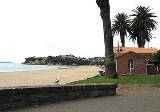
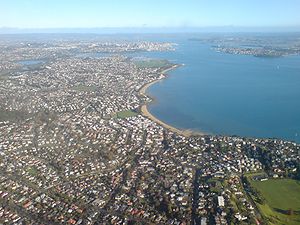
Saint Heliers, New Zealand
Encyclopedia
Auckland City
Auckland City was the city and local authority covering the Auckland isthmus and most of the islands of the Hauraki Gulf, in the North Island of New Zealand. On 1 November 2010 it was amalgamated into the wider Auckland Region under the authority of the new Auckland Council...
suburb
Suburb
The word suburb mostly refers to a residential area, either existing as part of a city or as a separate residential community within commuting distance of a city . Some suburbs have a degree of administrative autonomy, and most have lower population density than inner city neighborhoods...
, located at the eastern end of the city, where the Tamaki estuary divides it from Manukau City.
This area was originally called Glen Orchard after Lieutenant-Colonel William Taylor's farm. Under later owners it was a stud farm managed by a Major Walmsley who apparently suggested the name Saint Heliers Bay because of its resemblance to the Bay of St Heliers, a fashionable holiday resort on the Channel Island of Jersey.
The "St Heliers and Northcote Land Company" was formed in 1882. The purpose of this company was not only to sell land but to provide a horse tram service for Auckland. Land sales were poor and the scheme eventually failed but the company did build a 1500 feet (457.2 m) at St Heliers before becoming insolvent.
St Heliers was usually reached by boat, the trip from Auckland taking only 30 minutes, whereas the eight mile land route via Newmarket
Newmarket, New Zealand
Newmarket is an Auckland suburb to the south-east of the central business district. With its high building density, especially of retail shops, it is considered New Zealand's premier retailing area, and a rival of local competitor Auckland CBD...
, Remuera
Remuera
Remuera is a residential suburban area within Auckland city, in the North Island of New Zealand. It is located four kilometres to the southeast of the city centre...
and Meadowbank
Meadowbank, New Zealand
Meadowbank is a suburb of Auckland city, in the North Island of New Zealand.Meadowbank is under the local governance of the Auckland City Council...
was usually far too onerous. During this period St Heliers was a centre for local farmers and the location of the villas of a few rich business people. After Tamaki Drive was built in the late 1920s St Heliers became a commuter suburb and a destination for Sunday drives, altering its genteel image.
The wharf is long gone but there is periodically talk of rebuilding it, especially when Tamaki Drive is gridlocked with traffic. There have been temporary wharves put in place during the summer months in the past.
Geography
St Heliers has one relatively unknown volcano, a maarMaar
A maar is a broad, low-relief volcanic crater that is caused by a phreatomagmatic eruption, an explosion caused by groundwater coming into contact with hot lava or magma. A maar characteristically fills with water to form a relatively shallow crater lake. The name comes from the local Moselle...
of unknown age. Its crater had formed a swamp by the time Europeans arrived, and was later converted into the sports fields of Glover Park. On the seaward side, a pā
Pa (Maori)
The word pā can refer to any Māori village or settlement, but in traditional use it referred to hillforts fortified with palisades and defensive terraces and also to fortified villages. They first came into being about 1450. They are located mainly in the North Island north of lake Taupo...
has once stood, and the landward side is marked by the water tower at its highest point.