
Saint-François River
Encyclopedia
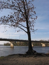
The Saint-François River is a river in the Canadian
province of Quebec
.
The Saint-François takes its source from Lake Saint-François
in Chaudière-Appalaches
, southeast of Thetford Mines. It flows southwest towards Sherbrooke, where it changes it course northwest towards Drummondville, and finally emptying into the Saint Lawrence River
near Pierreville
.
About 15 km upstream of the centre of Drummondville, a meander
in the river forms a shape strongly resembling a profile drawing of a duck's head and neck, with an island marking the eye. The peninsula forming the "beak of the duck" is named accordingly, le Bec du Canard, and the
road running along it is Rue du Bec-du-Canard.
Canada
Canada is a North American country consisting of ten provinces and three territories. Located in the northern part of the continent, it extends from the Atlantic Ocean in the east to the Pacific Ocean in the west, and northward into the Arctic Ocean...
province of Quebec
Quebec
Quebec or is a province in east-central Canada. It is the only Canadian province with a predominantly French-speaking population and the only one whose sole official language is French at the provincial level....
.
The Saint-François takes its source from Lake Saint-François
Lac Saint-François (Estrie)
Lac Saint-François is a 51-km² body of water located southeast of the city of Thetford Mines, in southeastern Quebec. Much of the lake is surrounded by the Frontenac National Park. It is the source of the Saint-François River. There are six communities on the shores of the lake, the largest of...
in Chaudière-Appalaches
Chaudière-Appalaches
Chaudière-Appalaches is an administrative region in Quebec, Canada. It comprises most of what is historically known as the "Beauce" |the electoral district of Beauce]]). It is named for the Chaudière River and the Appalachian Mountains....
, southeast of Thetford Mines. It flows southwest towards Sherbrooke, where it changes it course northwest towards Drummondville, and finally emptying into the Saint Lawrence River
Saint Lawrence River
The Saint Lawrence is a large river flowing approximately from southwest to northeast in the middle latitudes of North America, connecting the Great Lakes with the Atlantic Ocean. It is the primary drainage conveyor of the Great Lakes Basin...
near Pierreville
Pierreville, Quebec
Pierreville is a community in Nicolet-Yamaska Regional County Municipality, Quebec, located at the confluence of the Saint Lawrence and Saint-François rivers, at the edge of Lac Saint-Pierre. The population as of the Canada 2006 Census was 2,337....
.
About 15 km upstream of the centre of Drummondville, a meander
Meander
A meander in general is a bend in a sinuous watercourse. A meander is formed when the moving water in a stream erodes the outer banks and widens its valley. A stream of any volume may assume a meandering course, alternately eroding sediments from the outside of a bend and depositing them on the...
in the river forms a shape strongly resembling a profile drawing of a duck's head and neck, with an island marking the eye. The peninsula forming the "beak of the duck" is named accordingly, le Bec du Canard, and the
road running along it is Rue du Bec-du-Canard.