
Ryhope
Encyclopedia
Ryhope is a coastal village along the southern boundary of the City of Sunderland
, in Tyne and Wear
, North East
England
. With a population of approximately 14,000, Ryhope is 2.9 miles to the centre of Sunderland, 2.8 miles to the centre of Seaham
, and 1 .2 miles from the main A19
.
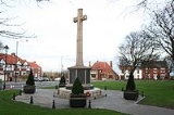
The older village section is centred around a triangular 'green', which contains a war monument. The newer 'Colliery' area of Ryhope flanks the Ryhope Street/Tunstall Bank road, which lead toward the Tunstall and Silksworth areas of Sunderland.
 The A1018
'Southern Radial Route', which opened in 2008, bypasses Ryhope along the clifftops and takes traffic toward the Port of Sunderland in Hendon and other routes to the centre and north of Sunderland.
The B1287 Sea View Road links Ryhope with the town of Seaham
to the south.
Ryhope is surrounded by farmland meaning it is a relatively isolated suburb of Sunderland.
A number of cycle routes run through the village, including the National Cycle Network
Route number 1 which is looked after by a local team of Sustrans Rangers. The Rangers have their own website for assistance and feedback on the cycle routes in Wearside this is www.cycle-routes.org/wearsiderangers.
Located to the south-west of the village is Cherry Knowle Hospital which is part of the South of Tyne and Wearside Mental Health NHS Trust. It has long been the main mental health services complex for the Wearside area. The Ryhope Engines Museum is also located in this area.
Ryhope has long formed part of the Houghton and Washington East (UK Parliament constituency), but following boundary changes it will be moved to Sunderland Central for the next general election.
. The land had been reclaimed from the Vikings who had captured it in 918AD.
Ryhope has a strong history of farming; in 1183 there were 22 recorded Villeins who provided the landowner with cattle and crops. in 1380 the population had swelled to approximately 150. In 1860 common grazing land was split into plots, which radiated out in strips from the village green. Ryhope's proximity to the sea has allowed it to serve as a seaside destination for centuries. The beach is said to have been a favourite sea-bathing spot for the Bishop of Durham.
Located on the Durham
coalfield, it was inevitable that Ryhope would follow the path of many other villages in the area, and abandon agriculture as the main employeer in favour of coal
. In 1859 a colliery was opened, causing huge changes in the geography of the village. The settlement of Ryhope extended west toward the area of Tunstall
, creating two distinct areas of Ryhope; the 'Village' and the 'Colliery' (the post-WWII, council-built estate of 'Hollycarrside' forms a third section.) Railway lines were introduced to the area, linking Ryhope to Sunderland, Seaham
and other Durham Coalfield mining villages. Now only a single railway line runs through the village, although there is no longer a station. The colliery was closed in 1966.
Notable "Ryhopeans" include former Sunderland AFC manager Mick Buxton
, pop-music TV producers Malcolm Gerrie and Chris Cowey (both of the latter taught at Ryhope Comprehensive School - formerly Ryhope Grammar School, which closed in the late 1980s) and John Burdon, a former miner who became a director of Darchem, a major North Eastern industrial company.
The village's most-visited man-made landmark is Ryhope Engines Museum
, based on the Ryhope Pumping Station
which was built in 1868 to supply water to the Sunderland area.
Among natural features, Ryhope adjoins Tunstall Hills
which afford spectacular views of the entire city of Sunderland and far beyond (on a clear day, down the coast almost to Whitby
.) The Tunstall Hills are located on the southern outskirts of Sunderland between (New) Silksworth
and Ryhope. The disused quarries and cuttings at Tunstall Hills provide exposure through part of the Magnesian Limestone succession of Permian
age. Gentle slopes on the "Maiden Paps" section support species such as blue moor-grass, common rock-rose, perennial flax and locally uncommon plants such as Frog Orchid
, Autumn Gentian and Purple Milk-Vetch. These areas have been designated a "site of special scientific interest" (SSSI).
Ryhope has a large number of public houses for a village of its size. These include the Blue Bell, Railway Inn, Guide Post, Top House, Prince of Wales, Albion, and Wellington - in addition to several private clubs.
City of Sunderland
The City of Sunderland is a local government district of Tyne and Wear, in North East England, with the status of a city and metropolitan borough...
, in Tyne and Wear
Tyne and Wear
Tyne and Wear is a metropolitan county in north east England around the mouths of the Rivers Tyne and Wear. It came into existence as a metropolitan county in 1974 after the passage of the Local Government Act 1972...
, North East
North East England
North East England is one of the nine official regions of England. It covers Northumberland, County Durham, Tyne and Wear, and Teesside . The only cities in the region are Durham, Newcastle upon Tyne and Sunderland...
England
England
England is a country that is part of the United Kingdom. It shares land borders with Scotland to the north and Wales to the west; the Irish Sea is to the north west, the Celtic Sea to the south west, with the North Sea to the east and the English Channel to the south separating it from continental...
. With a population of approximately 14,000, Ryhope is 2.9 miles to the centre of Sunderland, 2.8 miles to the centre of Seaham
Seaham
Seaham, formerly Seaham Harbour, is a small town in County Durham, situated south of Sunderland and east of Durham. It has a small parish church, St Mary the Virgin, with a late 7th century Anglo Saxon nave resembling the church at Escomb in many respects. St Mary the Virgin is regarded as one of...
, and 1 .2 miles from the main A19
A19 road
The A19 is a major road in England running approximately parallel to and east of the A1 road, although the two roads meet at the northern end of the A19, the two roads originally met at the southern end of the A19 in Doncaster but the old route of the A1 was changed to the A638. From Sunderland...
.
The older village section is centred around a triangular 'green', which contains a war monument. The newer 'Colliery' area of Ryhope flanks the Ryhope Street/Tunstall Bank road, which lead toward the Tunstall and Silksworth areas of Sunderland.
Geography and administration
A1018 road
The A1018 is a road in North East England. It runs between South Shields, at the mouth of the River Tyne, and the A19 near Seaham, County Durham. Most of the route it follows is the old alignment of the A19, before it by-passed Sunderland to meet the Tyne Tunnel.-South Tyneside section:The road...
'Southern Radial Route', which opened in 2008, bypasses Ryhope along the clifftops and takes traffic toward the Port of Sunderland in Hendon and other routes to the centre and north of Sunderland.
The B1287 Sea View Road links Ryhope with the town of Seaham
Seaham
Seaham, formerly Seaham Harbour, is a small town in County Durham, situated south of Sunderland and east of Durham. It has a small parish church, St Mary the Virgin, with a late 7th century Anglo Saxon nave resembling the church at Escomb in many respects. St Mary the Virgin is regarded as one of...
to the south.
Ryhope is surrounded by farmland meaning it is a relatively isolated suburb of Sunderland.
A number of cycle routes run through the village, including the National Cycle Network
National Cycle Network
The National Cycle Network is a network of cycle routes in the United Kingdom.The National Cycle Network was created by the charity Sustrans , and aided by a £42.5 million National Lottery grant. In 2005 it was used for over 230 million trips.Many routes hope to minimise contact with motor...
Route number 1 which is looked after by a local team of Sustrans Rangers. The Rangers have their own website for assistance and feedback on the cycle routes in Wearside this is www.cycle-routes.org/wearsiderangers.
Located to the south-west of the village is Cherry Knowle Hospital which is part of the South of Tyne and Wearside Mental Health NHS Trust. It has long been the main mental health services complex for the Wearside area. The Ryhope Engines Museum is also located in this area.
Ryhope has long formed part of the Houghton and Washington East (UK Parliament constituency), but following boundary changes it will be moved to Sunderland Central for the next general election.
History
Ryhope (from the Old English reof hoppas, meaning 'rough valley') is first mentioned in 930AD when king Athelstan granted the land of Bishopwearmouth (including the township of Ryhope) to the Bishop of Chester-le-StreetChester-le-Street
Chester-le-Street is a town in County Durham, England. It has a history going back to Roman times when it was called Concangis. The town is located south of Newcastle upon Tyne and west of Sunderland on the River Wear...
. The land had been reclaimed from the Vikings who had captured it in 918AD.
Ryhope has a strong history of farming; in 1183 there were 22 recorded Villeins who provided the landowner with cattle and crops. in 1380 the population had swelled to approximately 150. In 1860 common grazing land was split into plots, which radiated out in strips from the village green. Ryhope's proximity to the sea has allowed it to serve as a seaside destination for centuries. The beach is said to have been a favourite sea-bathing spot for the Bishop of Durham.
Located on the Durham
Durham
Durham is a city in north east England. It is within the County Durham local government district, and is the county town of the larger ceremonial county...
coalfield, it was inevitable that Ryhope would follow the path of many other villages in the area, and abandon agriculture as the main employeer in favour of coal
Coal
Coal is a combustible black or brownish-black sedimentary rock usually occurring in rock strata in layers or veins called coal beds or coal seams. The harder forms, such as anthracite coal, can be regarded as metamorphic rock because of later exposure to elevated temperature and pressure...
. In 1859 a colliery was opened, causing huge changes in the geography of the village. The settlement of Ryhope extended west toward the area of Tunstall
Tunstall, Sunderland
Tunstall is a suburb of Sunderland which is mostly a privately purchased estate. It is located to the west of Ryhope, and east of Silksworth. The area was built around a large hill, known as Tunstall Hill....
, creating two distinct areas of Ryhope; the 'Village' and the 'Colliery' (the post-WWII, council-built estate of 'Hollycarrside' forms a third section.) Railway lines were introduced to the area, linking Ryhope to Sunderland, Seaham
Seaham
Seaham, formerly Seaham Harbour, is a small town in County Durham, situated south of Sunderland and east of Durham. It has a small parish church, St Mary the Virgin, with a late 7th century Anglo Saxon nave resembling the church at Escomb in many respects. St Mary the Virgin is regarded as one of...
and other Durham Coalfield mining villages. Now only a single railway line runs through the village, although there is no longer a station. The colliery was closed in 1966.
Notable "Ryhopeans" include former Sunderland AFC manager Mick Buxton
Mick Buxton
Michael James "Mick" Buxton is a former footballer and football manager in England. He has managed Huddersfield Town, Scunthorpe United and Sunderland.-Playing career:...
, pop-music TV producers Malcolm Gerrie and Chris Cowey (both of the latter taught at Ryhope Comprehensive School - formerly Ryhope Grammar School, which closed in the late 1980s) and John Burdon, a former miner who became a director of Darchem, a major North Eastern industrial company.
The village's most-visited man-made landmark is Ryhope Engines Museum
Ryhope Engines Museum
The Ryhope Engines Museum is a visitor attraction in the Ryhope suburb of Sunderland, Tyne and Wear.The Grade II* listed building is the most visited man-made landmark in Ryhope and is based at The Ryhope Pumping Station, operational for 100 years before closing in 1967.The volunteer-run museum...
, based on the Ryhope Pumping Station
Pumping station
Pumping stations are facilities including pumps and equipment for pumping fluids from one place to another. They are used for a variety of infrastructure systems, such as the supply of water to canals, the drainage of low-lying land, and the removal of sewage to processing sites.A pumping station...
which was built in 1868 to supply water to the Sunderland area.
Among natural features, Ryhope adjoins Tunstall Hills
Tunstall Hills
Tunstall Hills is an area of open space in Sunderland, Tyne and Wear, England. The area consists of Green Hill and Rocky Hill and surrounding land, and is the site of a local nature reserve....
which afford spectacular views of the entire city of Sunderland and far beyond (on a clear day, down the coast almost to Whitby
Whitby
Whitby is a seaside town, port and civil parish in the Scarborough borough of North Yorkshire, England. Situated on the east coast of Yorkshire at the mouth of the River Esk, Whitby has a combined maritime, mineral and tourist heritage, and is home to the ruins of Whitby Abbey where Caedmon, the...
.) The Tunstall Hills are located on the southern outskirts of Sunderland between (New) Silksworth
Silksworth
Silksworth is a former coal mining village in Sunderland, located next to Tunstall, Farringdon and Gilley LawSilksworth a brief history:Silksworth is a former colliery village with a 100 year coal mining heritage...
and Ryhope. The disused quarries and cuttings at Tunstall Hills provide exposure through part of the Magnesian Limestone succession of Permian
Permian
The PermianThe term "Permian" was introduced into geology in 1841 by Sir Sir R. I. Murchison, president of the Geological Society of London, who identified typical strata in extensive Russian explorations undertaken with Edouard de Verneuil; Murchison asserted in 1841 that he named his "Permian...
age. Gentle slopes on the "Maiden Paps" section support species such as blue moor-grass, common rock-rose, perennial flax and locally uncommon plants such as Frog Orchid
Frog Orchid
The Frog Orchid, or Coeloglossum viride, also known as the Long-Bracted Green Orchid and Dactylorhiza viridis is a monotypic genus of the family Orchidaceae generally found within the palearctic ecozone throughout the mid to northern United States through Canada, and in the British Isles and parts...
, Autumn Gentian and Purple Milk-Vetch. These areas have been designated a "site of special scientific interest" (SSSI).
Ryhope has a large number of public houses for a village of its size. These include the Blue Bell, Railway Inn, Guide Post, Top House, Prince of Wales, Albion, and Wellington - in addition to several private clubs.