
Rugby Western Relief Road
Encyclopedia
The Rugby Western Relief Road (RWRR) is a 3.7 miles (6 km) single carriageway road which is on the outskirts of Rugby, Warwickshire
, England
. The £36.6 million scheme includes a £17.08 million contribution from the Department for Transport
and was expected to be completed by the end of 2009 but the date was put back by a year, eventually opening in September 2010. There was also much speculation that the project went well over budget. Due to its route it can be considered in many ways to be a bypass
.
had finalised and submitted their plans which were accepted in October that year. In December 2005 the Department for Transport approved Compulsory Purchase and Side Roads Orders, albeit with slight modifications to the plan regarding the extreme southern end of the road. The construction company Carillion, who have also worked on the M6 toll
and the 2009 M6 extension, were awarded the contract.
Special consideration has been taken to reduce the environmental impact of the new road. Since 2002 the County Council and Carillion worked with Penny Anderson Associates Limited to protect local wildlife, especially local bat
s and badgers. Elsewhere over 15,000 trees are due to be planted and 2 miles (3.2 km) of new hedgerows laid. 25 acres (101,171.5 m²) of wildflowers will be planted and several 'balancing pools' dug to try and help cancel out the negative environmental impact of the new road.
, itself just 0.6 mile (0.965604 km) outside Rugby. From there it will skirt the western side of the town, crossing the A428
in New Bilton
before cutting through the north of the town to join the A426
which in turn joins the M6 motorway
just north of the town.
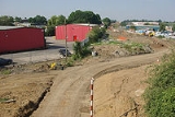
Work was begun in August 2007, nearly ten years after public consultation began. After months of building temporary service routes, major earthworking started in May 2008 along the southern section of the road. By the start of September that year tarmac was starting to be laid on this section and earthworking was starting elsewhere. For the rest of the year the roundabout
at the south end of the road, along with strengthening of existing bridges started. In January 2009 industrial contaminants were found on a part of the proposed route on land formerly owned by Cemex
, one of whose plants are next to the road. These however were quickly identified and removed. In March 2009 a roundabout
was completed on the A4071 which will take drivers off it and onto the Relief Road. During construction local school children and interested members of the public have been able to have pre-planned visits to the site.
In July 2009 the bridge the took the Lawford Road over the disused railway was taken down and the Lawford Road was diverted to make way for what will become the largest signalised
junction in Warwickshire
. As of November 2009 the southern section from the A4071 to the Lawford Road was waiting to be topped off. Further north up the route the earthworks have been completed.
On 19 June 2010 the southern section of the road from Potford's Dam to Lawford Road opened to traffic. This was preceded by a charity open day of the route allowing local people to explore the route in safety. The remainder of the route was opened on 10 September 2010.
was down 14 per cent.
Rugby, Warwickshire
Rugby is a market town in Warwickshire, England, located on the River Avon. The town has a population of 61,988 making it the second largest town in the county...
, England
England
England is a country that is part of the United Kingdom. It shares land borders with Scotland to the north and Wales to the west; the Irish Sea is to the north west, the Celtic Sea to the south west, with the North Sea to the east and the English Channel to the south separating it from continental...
. The £36.6 million scheme includes a £17.08 million contribution from the Department for Transport
Department for Transport
In the United Kingdom, the Department for Transport is the government department responsible for the English transport network and a limited number of transport matters in Scotland, Wales and Northern Ireland which are not devolved...
and was expected to be completed by the end of 2009 but the date was put back by a year, eventually opening in September 2010. There was also much speculation that the project went well over budget. Due to its route it can be considered in many ways to be a bypass
Bypass (road)
A bypass is a road or highway that avoids or "bypasses" a built-up area, town, or village, to let through traffic flow without interference from local traffic, to reduce congestion in the built-up area, and to improve road safety....
.
Planning and pre-construction
Public consultation regarding the roads was started in November 1997 about a decade before construction began and ended two months later in January 1998. The original road plan had it running through Cawston and not around it but the extra funding was quickly found to change this. In September 2002 Rugby Borough CouncilRugby (borough)
Rugby is a local government district with borough status in eastern Warwickshire, England.The borough comprises the town of Rugby where the council has its headquarters, and the rural areas surrounding the town....
had finalised and submitted their plans which were accepted in October that year. In December 2005 the Department for Transport approved Compulsory Purchase and Side Roads Orders, albeit with slight modifications to the plan regarding the extreme southern end of the road. The construction company Carillion, who have also worked on the M6 toll
M6 Toll
The M6 Toll , connects M6 Junction 4 at the NEC to M6 Junction 11A at Wolverhampton with of six-lane motorway. The weekday cash cost is £5.30 for a car and £10.60 for a HGV...
and the 2009 M6 extension, were awarded the contract.
Special consideration has been taken to reduce the environmental impact of the new road. Since 2002 the County Council and Carillion worked with Penny Anderson Associates Limited to protect local wildlife, especially local bat
Bat
Bats are mammals of the order Chiroptera "hand" and pteron "wing") whose forelimbs form webbed wings, making them the only mammals naturally capable of true and sustained flight. By contrast, other mammals said to fly, such as flying squirrels, gliding possums, and colugos, glide rather than fly,...
s and badgers. Elsewhere over 15,000 trees are due to be planted and 2 miles (3.2 km) of new hedgerows laid. 25 acres (101,171.5 m²) of wildflowers will be planted and several 'balancing pools' dug to try and help cancel out the negative environmental impact of the new road.
Route and construction
The road will leave the existing A4071 just west of the village of CawstonCawston, Warwickshire
Cawston is a civil parish and village close to the south west of Rugby, Warwickshire, on the A4071 . For hundreds of years the village was basically a hamlet and the two settlements remained separate despite Rugby's continued growth. However in 2003-04 a new housing estate, Cawston Grange, was...
, itself just 0.6 mile (0.965604 km) outside Rugby. From there it will skirt the western side of the town, crossing the A428
A428 road
The A428 road is a major road in central and eastern England. It connects the cities of Coventry and Cambridge by way of the county towns of Northampton and Bedford.-Coventry - Northampton:...
in New Bilton
New Bilton
New Bilton is a place in Rugby, Warwickshire, in England. It is a suburb of Rugby, situated to the west of the town centre. The nearby village of Bilton has also been absorbed into Rugby....
before cutting through the north of the town to join the A426
A426 road
The A426 road is a road in England which runs from the city of Leicester to the market town of Southam in Warwickshire via the towns of Lutterworth and Rugby.-History:...
which in turn joins the M6 motorway
M6 motorway
The M6 motorway runs from junction 19 of the M1 at the Catthorpe Interchange, near Rugby via Birmingham then heads north, passing Stoke-on-Trent, Manchester, Preston, Carlisle and terminating at the Gretna junction . Here, just short of the Scottish border it becomes the A74 which continues to...
just north of the town.
Work was begun in August 2007, nearly ten years after public consultation began. After months of building temporary service routes, major earthworking started in May 2008 along the southern section of the road. By the start of September that year tarmac was starting to be laid on this section and earthworking was starting elsewhere. For the rest of the year the roundabout
Roundabout
A roundabout is the name for a road junction in which traffic moves in one direction around a central island. The word dates from the early 20th century. Roundabouts are common in many countries around the world...
at the south end of the road, along with strengthening of existing bridges started. In January 2009 industrial contaminants were found on a part of the proposed route on land formerly owned by Cemex
Cemex
CEMEX is the world's largest building materials supplier and third largest cement producer. Founded in Mexico in 1906, the company is based in Monterrey, Mexico...
, one of whose plants are next to the road. These however were quickly identified and removed. In March 2009 a roundabout
Roundabout
A roundabout is the name for a road junction in which traffic moves in one direction around a central island. The word dates from the early 20th century. Roundabouts are common in many countries around the world...
was completed on the A4071 which will take drivers off it and onto the Relief Road. During construction local school children and interested members of the public have been able to have pre-planned visits to the site.
In July 2009 the bridge the took the Lawford Road over the disused railway was taken down and the Lawford Road was diverted to make way for what will become the largest signalised
Traffic light
Traffic lights, which may also be known as stoplights, traffic lamps, traffic signals, signal lights, robots or semaphore, are signalling devices positioned at road intersections, pedestrian crossings and other locations to control competing flows of traffic...
junction in Warwickshire
Warwickshire
Warwickshire is a landlocked non-metropolitan county in the West Midlands region of England. The county town is Warwick, although the largest town is Nuneaton. The county is famous for being the birthplace of William Shakespeare...
. As of November 2009 the southern section from the A4071 to the Lawford Road was waiting to be topped off. Further north up the route the earthworks have been completed.
On 19 June 2010 the southern section of the road from Potford's Dam to Lawford Road opened to traffic. This was preceded by a charity open day of the route allowing local people to explore the route in safety. The remainder of the route was opened on 10 September 2010.
Effects of road
A study was carried out in September 2011 by Warwickshire County Council to discover what effect the new road was having on traffic levels on other roads it was built to relieve. The results indicated that traffic on Bilton Lane had dropped by 79 per cent, the A4071 Main Street in Bilton was down 28 per cent, the number of vehicles using the A426 Newbold Road had fallen by 26 per cent, and the A428 at Church LawfordChurch Lawford
Church Lawford is a village in Warwickshire. It is located just under west of the town of Rugby and east of Coventry. The village lies north of the railway between the two and is also north of the main road, the A428. To the north is the River Avon....
was down 14 per cent.