
.gif)
Route 5 (Rhode Island)
Encyclopedia
Route description
- WarwickWarwick, Rhode IslandWarwick is a city in Kent County, Rhode Island, United States. It is the second largest city in the state, with a population of 82,672 at the 2010 census. Its mayor has been Scott Avedisian since 2000...
: 2.9 miles (4.7 km); US 1 to CranstonCranston, Rhode IslandCranston, once known as Pawtuxet, is a city in Providence County, Rhode Island, United States. With a population of 80,387 at the 2010 census, it is the third largest city in the state. The center of population of Rhode Island is located in Cranston...
city line- Greenwich Avenue and Lambert Lind Highway
- CranstonCranston, Rhode IslandCranston, once known as Pawtuxet, is a city in Providence County, Rhode Island, United States. With a population of 80,387 at the 2010 census, it is the third largest city in the state. The center of population of Rhode Island is located in Cranston...
: 4.9 miles (7.9 km); WarwickWarwick, Rhode IslandWarwick is a city in Kent County, Rhode Island, United States. It is the second largest city in the state, with a population of 82,672 at the 2010 census. Its mayor has been Scott Avedisian since 2000...
city line to JohnstonJohnston, Rhode IslandJohnston is a town in Providence County, Rhode Island, United States. The population was 28,769 at the 2010 census. Johnston is the site of the Clemence Irons House a stone-ender museum and the only landfill in Rhode Island...
town line- Oaklawn Avenue and Atwood Avenue
- JohnstonJohnston, Rhode IslandJohnston is a town in Providence County, Rhode Island, United States. The population was 28,769 at the 2010 census. Johnston is the site of the Clemence Irons House a stone-ender museum and the only landfill in Rhode Island...
: 6 miles (9.7 km); CranstonCranston, Rhode IslandCranston, once known as Pawtuxet, is a city in Providence County, Rhode Island, United States. With a population of 80,387 at the 2010 census, it is the third largest city in the state. The center of population of Rhode Island is located in Cranston...
city line to SmithfieldSmithfield, Rhode IslandSmithfield is a town in Providence County, Rhode Island, United States. It includes the historic villages of Esmond, Georgiaville, Mountaindale, Hanton City, Stillwater and Greenville...
town line- Atwood Avenue, Greenville Avenue and Sanderson Road
- SmithfieldSmithfield, Rhode IslandSmithfield is a town in Providence County, Rhode Island, United States. It includes the historic villages of Esmond, Georgiaville, Mountaindale, Hanton City, Stillwater and Greenville...
: 5.7 miles (9.2 km); JohnstonJohnston, Rhode IslandJohnston is a town in Providence County, Rhode Island, United States. The population was 28,769 at the 2010 census. Johnston is the site of the Clemence Irons House a stone-ender museum and the only landfill in Rhode Island...
town line to North SmithfieldNorth Smithfield, Rhode IslandNorth Smithfield is a town in Providence County, Rhode Island, United States, settled as a farming community in 1666 and incorporated into its present form in 1871. North Smithfield includes the historic villages of Forestdale, Primrose, Waterford, Branch Village, Union Village, Park Square, and...
town line- Sanderson Road, Cedar Swamp Road, Pleasant View Avenue and Farnum Pike
- North SmithfieldNorth Smithfield, Rhode IslandNorth Smithfield is a town in Providence County, Rhode Island, United States, settled as a farming community in 1666 and incorporated into its present form in 1871. North Smithfield includes the historic villages of Forestdale, Primrose, Waterford, Branch Village, Union Village, Park Square, and...
: 6.5 miles (10.5 km); SmithfieldSmithfield, Rhode IslandSmithfield is a town in Providence County, Rhode Island, United States. It includes the historic villages of Esmond, Georgiaville, Mountaindale, Hanton City, Stillwater and Greenville...
town line to MassachusettsMassachusettsThe Commonwealth of Massachusetts is a state in the New England region of the northeastern United States of America. It is bordered by Rhode Island and Connecticut to the south, New York to the west, and Vermont and New Hampshire to the north; at its east lies the Atlantic Ocean. As of the 2010...
State line at Central Street- Farnum Pike, Douglas Pike, Greenville Road, Providence Pike, Railroad Street, Main Street, North Main Street and Central Avenue
Junction list
| County | Town New England town The New England town is the basic unit of local government in each of the six New England states. Without a direct counterpart in most other U.S. states, New England towns are conceptually similar to civil townships in other states, but are incorporated, possessing powers like cities in other... |
Mile | Destinations | Notes |
|---|---|---|---|---|
| Kent Kent County, Rhode Island -Demographics:As of the census of 2000, there were 167,090 people, 67,320 households, and 44,969 families residing in the county. The population density was 982 people per square mile . There were 70,365 housing units at an average density of 414 per square mile... |
Warwick Warwick, Rhode Island Warwick is a city in Kent County, Rhode Island, United States. It is the second largest city in the state, with a population of 82,672 at the 2010 census. Its mayor has been Scott Avedisian since 2000... |
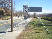
0.00 | Southern terminus of Route 5 | |
| Providence Providence County, Rhode Island -Demographics:As of the census of 2000, there were 621,602 people, 239,936 households, and 152,839 families residing in the county. The population density was 1,504 people per square mile . There were 253,214 housing units at an average density of 613 per square mile... |
Cranston Cranston, Rhode Island Cranston, once known as Pawtuxet, is a city in Providence County, Rhode Island, United States. With a population of 80,387 at the 2010 census, it is the third largest city in the state. The center of population of Rhode Island is located in Cranston... |
|||
| Cranston Street | Roundabout | |||
| Greenville Avenue | Route 5 turns left onto Greenville Avenue | |||
| Begin Route 116 overlap | ||||
| Route 5 and 116 turn north on Route 104 | ||||
| Route 116 leaves overlap | ||||
| Route 7 joins concurrency | ||||
| Route 7 leaves concurrency Routes 5 and 104 enter Greenville Road |
||||
| Route 104 leaves concurrency Route 5 enters Providence Pike |
||||
| Route 146A joins concurrency | ||||
| Route 146 leaves concurrency | ||||
| Northern terminus of Route 5 | ||||