
Rossville, Illinois
Encyclopedia
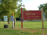
Rossville is a village in Ross Township
, Vermilion County
, Illinois
, United States
. It is part of the 'Danville, Illinois
Metropolitan Statistical Area'. The population was 1,217 at the 2000 census, and 1,147 in 2009.
 Rossville and Ross Township were named for Jacob Ross, a settler in the area. whoever, the location was first named Liggett's Grove in honor of John Liggett who built a lodging house there in 1829. Liggett's cabin was located on the Hubbard Trail, an early trading route established by Gurdon Hubbard
from Chicago to Danville. In 1833, this became the first state highway (now Illinois Route 1) and in 1914 was made part of the Dixie Highway. In 1838, Alvan Gilbert purchased the Liggett farm, and the next year became postmaster at the newly-established post office. Rossville was incorporated as a village in August 1859.
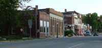
In February 2004, a fire broke out in the downtown business district and destroyed several of the historic buildings and antique shops for which Rossville has been known.
Rossville was also the hometown of Daniel Huffman, who gained fame in 1996 after donating a kidney to his grandmother and who was the subject of the 1999 television movie
Gift of Love: The Daniel Huffman Story.
Area attractions include the Rossville Historical Society Museum, the Rossville Railroad Depot Museum, Christman Park, and the Hubbard Trail Monument. South of Rossville are Historic Mann's Chapel (1857) and an original State Road Mile Marker from 1833.
, the village has a total area of 1.3 square miles (3.4 km²), all of it land.
of 2000, there were 1,217 people, 533 households, and 341 families residing in the village. The population density
was 905.1 people per square mile (350.7/km²). There were 596 housing units at an average density of 443.2 per square mile (171.7/km²). The racial makeup of the village was 97.78% White, 0.25% African American, 0.16% Native American, 0.08% Asian, 0.90% from other races
, and 0.82% from two or more races. Hispanic or Latino of any race were 2.14% of the population.
There were 533 households out of which 27.6% had children under the age of 18 living with them, 50.8% were married couples
living together, 10.1% had a female householder with no husband present, and 36.0% were non-families. 32.3% of all households were made up of individuals and 18.0% had someone living alone who was 65 years of age or older. The average household size was 2.28 and the average family size was 2.89.
In the village the population was spread out with 23.3% under the age of 18, 8.6% from 18 to 24, 25.2% from 25 to 44, 24.3% from 45 to 64, and 18.6% who were 65 years of age or older. The median age was 41 years. For every 100 females there were 89.9 males. For every 100 females age 18 and over, there were 86.1 males.
The median income for a household in the village was $36,442, and the median income for a family was $43,882. Males had a median income of $32,083 versus $19,813 for females. The per capita income
for the village was $16,794. About 7.8% of families and 9.8% of the population were below the poverty line, including 13.0% of those under age 18 and 8.8% of those age 65 or over.
The Rossville Community Organization is active in hosting community events. These include; Free A-Train week in September, Drivin' The Dixie Days, in June and Christmas in the Village on the first weekend in December.
and County Road 14, about 7 miles south of Hoopeston
and about 15 miles north of the county seat of Danville
. A railroad operated by CSX Transportation
passes through the east side of town.
Ross Township, Vermilion County, Illinois
Ross Township is a township in Vermilion County, Illinois, USA. As of the 2000 census, its population was 1,476.-Geography:Ross Township covers an area of ; of this, or 0.02 percent is water.-Adjacent townships:* Grant Township...
, Vermilion County
Vermilion County, Illinois
Vermilion County is a county located in the eastern part of the U.S. state of Illinois, between the Indiana border and Champaign County. It was established in 1826 and was the 45th of Illinois' 102 counties...
, Illinois
Illinois
Illinois is the fifth-most populous state of the United States of America, and is often noted for being a microcosm of the entire country. With Chicago in the northeast, small industrial cities and great agricultural productivity in central and northern Illinois, and natural resources like coal,...
, United States
United States
The United States of America is a federal constitutional republic comprising fifty states and a federal district...
. It is part of the 'Danville, Illinois
Danville, Illinois
Danville is a city in Vermilion County, Illinois, United States. It is the principal city of the'Danville, Illinois Metropolitan Statistical Area' which encompasses all of Danville and Vermilion County. As of the 2010 census, the city had a total population of 32,467. It is the county seat of...
Metropolitan Statistical Area'. The population was 1,217 at the 2000 census, and 1,147 in 2009.
History
Gurdon Saltonstall Hubbard
Gurdon Saltonstall Hubbard was an American fur trader, insurance underwriter and land speculator. Hubbard first arrived in Chicago on October 1, 1818 as a voyageur...
from Chicago to Danville. In 1833, this became the first state highway (now Illinois Route 1) and in 1914 was made part of the Dixie Highway. In 1838, Alvan Gilbert purchased the Liggett farm, and the next year became postmaster at the newly-established post office. Rossville was incorporated as a village in August 1859.
In February 2004, a fire broke out in the downtown business district and destroyed several of the historic buildings and antique shops for which Rossville has been known.
Rossville was also the hometown of Daniel Huffman, who gained fame in 1996 after donating a kidney to his grandmother and who was the subject of the 1999 television movie
Television movie
A television film is a feature film that is a television program produced for and originally distributed by a television network, in contrast to...
Gift of Love: The Daniel Huffman Story.
Area attractions include the Rossville Historical Society Museum, the Rossville Railroad Depot Museum, Christman Park, and the Hubbard Trail Monument. South of Rossville are Historic Mann's Chapel (1857) and an original State Road Mile Marker from 1833.
Geography
Rossville's coordinates are 40°22′50"N 87°40′7"W (40.380424, -87.668557). According to the United States Census BureauUnited States Census Bureau
The United States Census Bureau is the government agency that is responsible for the United States Census. It also gathers other national demographic and economic data...
, the village has a total area of 1.3 square miles (3.4 km²), all of it land.
Demographics
As of the censusCensus
A census is the procedure of systematically acquiring and recording information about the members of a given population. It is a regularly occurring and official count of a particular population. The term is used mostly in connection with national population and housing censuses; other common...
of 2000, there were 1,217 people, 533 households, and 341 families residing in the village. The population density
Population density
Population density is a measurement of population per unit area or unit volume. It is frequently applied to living organisms, and particularly to humans...
was 905.1 people per square mile (350.7/km²). There were 596 housing units at an average density of 443.2 per square mile (171.7/km²). The racial makeup of the village was 97.78% White, 0.25% African American, 0.16% Native American, 0.08% Asian, 0.90% from other races
Race (United States Census)
Race and ethnicity in the United States Census, as defined by the Federal Office of Management and Budget and the United States Census Bureau, are self-identification data items in which residents choose the race or races with which they most closely identify, and indicate whether or not they are...
, and 0.82% from two or more races. Hispanic or Latino of any race were 2.14% of the population.
There were 533 households out of which 27.6% had children under the age of 18 living with them, 50.8% were married couples
Marriage
Marriage is a social union or legal contract between people that creates kinship. It is an institution in which interpersonal relationships, usually intimate and sexual, are acknowledged in a variety of ways, depending on the culture or subculture in which it is found...
living together, 10.1% had a female householder with no husband present, and 36.0% were non-families. 32.3% of all households were made up of individuals and 18.0% had someone living alone who was 65 years of age or older. The average household size was 2.28 and the average family size was 2.89.
In the village the population was spread out with 23.3% under the age of 18, 8.6% from 18 to 24, 25.2% from 25 to 44, 24.3% from 45 to 64, and 18.6% who were 65 years of age or older. The median age was 41 years. For every 100 females there were 89.9 males. For every 100 females age 18 and over, there were 86.1 males.
The median income for a household in the village was $36,442, and the median income for a family was $43,882. Males had a median income of $32,083 versus $19,813 for females. The per capita income
Per capita income
Per capita income or income per person is a measure of mean income within an economic aggregate, such as a country or city. It is calculated by taking a measure of all sources of income in the aggregate and dividing it by the total population...
for the village was $16,794. About 7.8% of families and 9.8% of the population were below the poverty line, including 13.0% of those under age 18 and 8.8% of those age 65 or over.
The Rossville Community Organization is active in hosting community events. These include; Free A-Train week in September, Drivin' The Dixie Days, in June and Christmas in the Village on the first weekend in December.
Transportation
Rossville is located at the intersection of Illinois Route 1Illinois Route 1
Illinois Route 1 is a state highway in the U.S. state of Illinois. Running parallel to the Indiana border, it is also the longest state road, starting on the south side of Chicago as Halsted Street at the intersection with 95th Street, south to a free ferry crossing to Kentucky at Cave-In-Rock on...
and County Road 14, about 7 miles south of Hoopeston
Hoopeston, Illinois
Hoopeston is a city in Grant Township, Vermilion County, Illinois, United States. It is part of the Danville, Illinois, Metropolitan Statistical Area. The population was 5,965 at the 2000 census, and 5,602 in 2009.-History:Hoopeston was laid out in 1871...
and about 15 miles north of the county seat of Danville
Danville, Illinois
Danville is a city in Vermilion County, Illinois, United States. It is the principal city of the'Danville, Illinois Metropolitan Statistical Area' which encompasses all of Danville and Vermilion County. As of the 2010 census, the city had a total population of 32,467. It is the county seat of...
. A railroad operated by CSX Transportation
CSX Transportation
CSX Transportation operates a Class I railroad in the United States known as the CSX Railroad. It is the main subsidiary of the CSX Corporation. The company is headquartered in Jacksonville, Florida, and owns approximately 21,000 route miles...
passes through the east side of town.