
Rosine, Kentucky
Encyclopedia
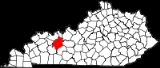
 Location of Ohio County in the state of Kentucky Kentucky The Commonwealth of Kentucky is a state located in the East Central United States of America. As classified by the United States Census Bureau, Kentucky is a Southern state, more specifically in the East South Central region. Kentucky is one of four U.S. states constituted as a commonwealth... |
|
| County | Ohio County Ohio County, Kentucky Ohio County is a county located in the U.S. state of Kentucky. As of 2000, the population was 22,916. Its county seat is Hartford. The county is named for the Ohio River, which originally formed its northern boundary. It is a dry county, which means that the sale of alcohol is restricted or... |
| Population Population A population is all the organisms that both belong to the same group or species and live in the same geographical area. The area that is used to define a sexual population is such that inter-breeding is possible between any pair within the area and more probable than cross-breeding with individuals... - Total |
41 |
| Time zone Time zone A time zone is a region on Earth that has a uniform standard time for legal, commercial, and social purposes. In order for the same clock time to always correspond to the same portion of the day as the Earth rotates , different places on the Earth need to have different clock times... - summer (DST Daylight saving time Daylight saving time —also summer time in several countries including in British English and European official terminology —is the practice of temporarily advancing clocks during the summertime so that afternoons have more daylight and mornings have less... ) |
CST (UTC Coordinated Universal Time Coordinated Universal Time is the primary time standard by which the world regulates clocks and time. It is one of several closely related successors to Greenwich Mean Time. Computer servers, online services and other entities that rely on having a universally accepted time use UTC for that purpose... -6) CDT (UTC Coordinated Universal Time Coordinated Universal Time is the primary time standard by which the world regulates clocks and time. It is one of several closely related successors to Greenwich Mean Time. Computer servers, online services and other entities that rely on having a universally accepted time use UTC for that purpose... -5) |
Rosine is an unincorporated town
Unincorporated area
In law, an unincorporated area is a region of land that is not a part of any municipality.To "incorporate" in this context means to form a municipal corporation, a city, town, or village with its own government. An unincorporated community is usually not subject to or taxed by a municipal government...
in Ohio County
Ohio County, Kentucky
Ohio County is a county located in the U.S. state of Kentucky. As of 2000, the population was 22,916. Its county seat is Hartford. The county is named for the Ohio River, which originally formed its northern boundary. It is a dry county, which means that the sale of alcohol is restricted or...
, Kentucky
Kentucky
The Commonwealth of Kentucky is a state located in the East Central United States of America. As classified by the United States Census Bureau, Kentucky is a Southern state, more specifically in the East South Central region. Kentucky is one of four U.S. states constituted as a commonwealth...
, United States
United States
The United States of America is a federal constitutional republic comprising fifty states and a federal district...
. Bill Monroe
Bill Monroe
William Smith Monroe was an American musician who created the style of music known as bluegrass, which takes its name from his band, the "Blue Grass Boys," named for Monroe's home state of Kentucky. Monroe's performing career spanned 60 years as a singer, instrumentalist, composer and bandleader...
, The Father of Bluegrass, is not only buried in the town but also memorialized with a bronze cast disk affixed to the barn where his music remains alive. The community was named for the pen name of Jenny Taylor McHenry, poet and wife of founder Henry D. McHenry. The ZIP Code
ZIP Code
ZIP codes are a system of postal codes used by the United States Postal Service since 1963. The term ZIP, an acronym for Zone Improvement Plan, is properly written in capital letters and was chosen to suggest that the mail travels more efficiently, and therefore more quickly, when senders use the...
is 42370 and the area code is 270. The nearest towns are Baizetown, Horse Branch, and Beaver Dam
Beaver Dam, Kentucky
Beaver Dam is a city in Ohio County, Kentucky, United States. The population was 3,033 at the 2000 census. It is named for nearby Beaver Dam Creek.-Geography:Beaver Dam is located at ....
, and the nearest major cities are Owensboro
Owensboro, Kentucky
Owensboro is the fourth largest city by population in the U.S. state of Kentucky. It is the county seat of Daviess County. It is located on U.S. Route 60 about southeast of Evansville, Indiana, and is the principal city of the Owensboro, Kentucky, Metropolitan Statistical Area. The city's...
and Bowling Green
Bowling Green, Kentucky
Bowling Green is the third-most populous city in the state of Kentucky after Louisville and Lexington, with a population of 58,067 as of the 2010 Census. It is the county seat of Warren County and the principal city of the Bowling Green, Kentucky Metropolitan Statistical Area with an estimated 2009...
. The community sits at an elevation of 429 feet.
Schools
There are no schools in Rosine. Students from Rosine attend Horse Branch Elementary School, Ohio County Middle School, and Ohio County High School. Nearby private schools include Sugar Grove Christian Academy and Ohio County Christian Academy. The nearest colleges and universities are in Owensboro.Major roads
U.S. Route 62U.S. Route 62
U.S. Route 62 runs from the US-Mexico border at El Paso, Texas to Niagara Falls, New York, near the United States-Canada border. It is the only east-west US Route that connects Mexico and Canada.Parts of U.S...
passes through Rosine. The town is north of the Wendell H Ford Western Kentucky Parkway and east of the William H Natcher / Green River Parkway.