
Rosemeadow, New South Wales
Encyclopedia
Rosemeadow is a suburb
Suburb
The word suburb mostly refers to a residential area, either existing as part of a city or as a separate residential community within commuting distance of a city . Some suburbs have a degree of administrative autonomy, and most have lower population density than inner city neighborhoods...
of Sydney
Sydney
Sydney is the most populous city in Australia and the state capital of New South Wales. Sydney is located on Australia's south-east coast of the Tasman Sea. As of June 2010, the greater metropolitan area had an approximate population of 4.6 million people...
, in the state of New South Wales
New South Wales
New South Wales is a state of :Australia, located in the east of the country. It is bordered by Queensland, Victoria and South Australia to the north, south and west respectively. To the east, the state is bordered by the Tasman Sea, which forms part of the Pacific Ocean. New South Wales...
, Australia
Australia
Australia , officially the Commonwealth of Australia, is a country in the Southern Hemisphere comprising the mainland of the Australian continent, the island of Tasmania, and numerous smaller islands in the Indian and Pacific Oceans. It is the world's sixth-largest country by total area...
. Rosemeadow is located 56 kilometres south-west of the Sydney central business district
Sydney central business district
The Sydney central business district is the main commercial centre of Sydney, New South Wales, Australia. It extends southwards for about 3 kilometres from Sydney Cove, the point of first European settlement. Its north–south axis runs from Circular Quay in the north to Central railway station in...
, in the local government area of the City of Campbelltown and is part of the Macarthur
Macarthur, New South Wales
Macarthur is a region in south-west of Sydney, in the state of New South Wales, Australia. The region includes the local government areas of the City of Campbelltown, Camden Council and Wollondilly Shire. It covers an area of 3,067 square kilometres and has a population of close to 240,000 residents...
region.
History
Rosemeadow owes its name to early settler Thomas Rose, who in 1818 bought a farm called Mount Gilead which covered parts of modern-day Rosemeadow and neighbouring GileadGilead, New South Wales
Gilead is a suburb of Sydney, in the state of New South Wales, Australia. Gilead is located 58 kilometres south-west of the Sydney central business district, in the local government area of the City of Campbelltown and is part of the Macarthur region....
. Rose was a baker and publican as well as a farmer, building a mill on his property and a couple of large dams which helped him and his neighbours survive the drought of 1829.
The area remained farmland until the mid 1970s when Sydney's urban sprawl reached it and the suburb was officially named in 1976.The Rosemeadow public housing estate is an example of the American Radburn design for public housing
American Radburn design for public housing
The American Radburn design for public housing is a reference the civil engineering designs for public housing estates applied in the 1970s in Sydney, Australia and other places. It is typified by the backyards of homes facing the street and the fronts of homes facing each other over common yards...
which turns houses around so they back on to streets with the fronts facing each other. This design has been criticised in Sydney as contributing to social problems and following an incident of street violence in 2009 orders were made to partially demolish the estate.
Commercial area
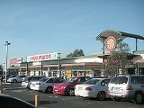
Rosemeadow Marketplace, on the corner of Copperfield Drive and Fitzgibbon Lane, is a medium-sized shopping centre. The local post office sits within the Marketplace and nearby is a community health centre, fire station, high school and an Anglican church.Schools
John Therry Catholic High School is the oldest school in the suburb, having opened in 1980. Next door is its feeder school, Our Lady Help of Christians Parish School. Public schools include Rosemeadow Public, Ambarvale High and Mary Brooksbank Special School.Transport
Rosemeadow can be accessed via M5 South Western MotorwayM5 South Western Motorway
The M5 South Western Motorway is a privately operated tolled motorway in south-western Sydney, New South Wales, Australia. It forms part of Sydney Metroad 5 and the Sydney Orbital Network...
and Appin Road. The suburb is serviced by Busways buses, which provide links to Macarthur and Campbelltown railway stations as well as occasional services to Appin
Appin, New South Wales
Appin is a town in the Macarthur Region of New South Wales, Australia in Wollondilly Shire. It is situated about 16 kilometres south of Campbelltown and 35 kilometres north west of Wollongong.-Early history:...
and Wollongong
Wollongong, New South Wales
Wollongong is a seaside city located in the Illawarra region of New South Wales, Australia. It lies on the narrow coastal strip between the Illawarra Escarpment and the Pacific Ocean, 82 kilometres south of Sydney...
.
People
According to the 2006 censusCensus
A census is the procedure of systematically acquiring and recording information about the members of a given population. It is a regularly occurring and official count of a particular population. The term is used mostly in connection with national population and housing censuses; other common...
, Rosemeadow had a population of 7,415 people. There were higher than average numbers of families with children (77%) and common occupations included technicians and tradespeople (18%), clerical and administrative (16%), labourers (13%) and machinery operators and drivers (13%). Three quarters of the suburb is detached housing with the remaining semi-detached or townhouses. More than half the homes are being purchased while around a fifth are rented from the Department of Housing..