
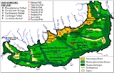
Romanian Plain
Encyclopedia
The Romanian Plain is located in southern Romania
and the easternmost tip of Serbia
. Part of the historical region
of Wallachia
, it is bordered by the Danube
River in the east, south and west, and by the Getic Plateau in the north. Bucharest
, the capital of Romania, is located in the central part of the Romanian Plain. It is contiguous to the south with the Danubian Plain
, in Bulgaria
. This area is also sometimes referred to as the Danubian Plain (Câmpia Dunării) in Romanian, though this designation is not specific, because the Danube flows through a number of plains along its course, such as the Hungarian Plain (which is called Danubian Plain in Slovakia and Serbia) as well as the Bavarian Lowland, also called Danubian plain.
Romania
Romania is a country located at the crossroads of Central and Southeastern Europe, on the Lower Danube, within and outside the Carpathian arch, bordering on the Black Sea...
and the easternmost tip of Serbia
Serbia
Serbia , officially the Republic of Serbia , is a landlocked country located at the crossroads of Central and Southeast Europe, covering the southern part of the Carpathian basin and the central part of the Balkans...
. Part of the historical region
Historical regions of Romania
At various times during the late 19th and 20th centuries, Romania extended over the following historical regions:Wallachia:*Muntenia or Greater Wallachia: as part of Wallachia, joined Moldavia in 1859 to create modern Romania;...
of Wallachia
Wallachia
Wallachia or Walachia is a historical and geographical region of Romania. It is situated north of the Danube and south of the Southern Carpathians...
, it is bordered by the Danube
Danube
The Danube is a river in the Central Europe and the Europe's second longest river after the Volga. It is classified as an international waterway....
River in the east, south and west, and by the Getic Plateau in the north. Bucharest
Bucharest
Bucharest is the capital municipality, cultural, industrial, and financial centre of Romania. It is the largest city in Romania, located in the southeast of the country, at , and lies on the banks of the Dâmbovița River....
, the capital of Romania, is located in the central part of the Romanian Plain. It is contiguous to the south with the Danubian Plain
Danubian Plain (Bulgaria)
The Danubian Plain constitutes the northern part of Bulgaria, situated north of the Balkan Mountains and south of the Danube. Its western border is the Timok River and to the east it borders the Black Sea. The plain has an area of . It is about long and wide.The relief of the Danubian Plain is...
, in Bulgaria
Bulgaria
Bulgaria , officially the Republic of Bulgaria , is a parliamentary democracy within a unitary constitutional republic in Southeast Europe. The country borders Romania to the north, Serbia and Macedonia to the west, Greece and Turkey to the south, as well as the Black Sea to the east...
. This area is also sometimes referred to as the Danubian Plain (Câmpia Dunării) in Romanian, though this designation is not specific, because the Danube flows through a number of plains along its course, such as the Hungarian Plain (which is called Danubian Plain in Slovakia and Serbia) as well as the Bavarian Lowland, also called Danubian plain.
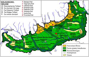
Subdivisions (W-E)
In Romania, the plain is divided into five subdivisions and the Danube Valley:- A. Olteniei Plain, located in the southern OlteniaOlteniaOltenia is a historical province and geographical region of Romania, in western Wallachia. It is situated between the Danube, the Southern Carpathians and the Olt river ....
:- Blahniţei;
- Băileştilor;
- Romanaţilor.
- B. Olt-Argeş (between the Olt RiverOlt RiverThe Olt River is a river in Romania. It is the longest river flowing exclusively through Romania. Its source is in the Hăşmaş Mountains of the eastern Carpathian Mountains, near the village Bălan. It flows through the Romanian counties Harghita, Covasna, Braşov, Sibiu, Vâlcea and Olt...
in the west and the Argeș RiverArges RiverArgeș is a river of Southern Romania. It starts at the junction of headwaters Buda and Capra in the Făgăraș Mountains, in the Southern Carpathians and flows into the Danube at Oltenița.The main city on the Argeş is Piteşti...
in the east):- Piteştiului;
- Boianului;
- Găvanu Burdea;
- Burnazului.
- C. Bucureştilor Plain:
- Târgoviştei;
- Ploieştilor;
- MizilMizilMizil is a town in Prahova County, Romania. Located in the southeastern part of the county, it lies along the road between the cities of Ploieşti and Buzău, and to the northeast of the national capital, Bucharest. Its position led it to become a thriving market town beginning in the 18th century,...
; - TituTituTitu is a town in Dâmboviţa County, southern Romania with a population of 10,226 , best known for its yearly September 14 bâlci .Titu is divided into three main zones...
; - Gherghiţei;
- Vlăsiei (see also Codrii VlăsieiCodrii VlasieiCodrii Vlăsiei was the forest that once covered parts of southern Romania, including the territory of today's Bucharest and the surrounding Ilfov County....
); - Câlnăului.
- D. Bărăgan PlainBaragan PlainThe Bărăgan Plain is a steppe plain in south-eastern Romania. It makes up much of the eastern part of the Wallachian Plain. The region is known for its black soil and a rich humus, and is mostly a cereal-growing area....
:- Bărăganul Călmăţuiului;
- Bărăganul Ialomiţei;
- Câlnăului;
- Mostiştei;
- E. The eastern plain:
- Râmnicului;
- Buzăului;
- Brăilei;
- Siretului Inferior;
- Tecuciului;
- CovurluiCovurluiThe Covurlui Plain is located in Galaţi County, Romania, having an altitude varying between 60 and 200 metres. Its name is derived from the Covurlui River and has a Cuman origin. Before World War II, Covurlui was the name of a county, but it was merged with Tecuci county to form the current Galaţi...
;
- Danube Valley:
- The proper Danube valley;
- The flooded marshy islands:
- Insula Mare a Brăilei or Balta Brăilei;
- Balta IalomiţeiBalta IalomiteiBalta Ialomiţei is an island on the Danube, located in Ialomiţa County and Călăraşi County, Romania. It is surrounded by two branches of the Danube, named "Borcea" and "Dunărea Veche". Originally, the island was covered with marshes, woods, lakes and ponds, but some of the land was reclaimed for...
.
Rivers
- NeajlovNeajlov RiverThe Neajlov is a river in Romania. It is a tributary of the Argeş River, which it meets near Comana, Giurgiu County. It rises from the Getic plateau and runs for .- Location :...
- JiuJiu RiverJiu is a river of southern Romania. It is formed near Petroşani by the junction of headwaters Jiul de Vest and Jiul de Est.It flows southward through the Romanian counties Hunedoara, Gorj and Dolj before flowing into the Danube a few kilometers upstream from the Bulgarian city of Oryahovo, 331...
- OltOlt RiverThe Olt River is a river in Romania. It is the longest river flowing exclusively through Romania. Its source is in the Hăşmaş Mountains of the eastern Carpathian Mountains, near the village Bălan. It flows through the Romanian counties Harghita, Covasna, Braşov, Sibiu, Vâlcea and Olt...
- VedeaVedea RiverThe Vedea River in southern Romania flows from the Cotmeana Plateau and runs into the Danube, having a total length of 224 km, of which 33 km is regulated.It flows in Argeş, Olt and Teleorman counties...
- ArgeșArges RiverArgeș is a river of Southern Romania. It starts at the junction of headwaters Buda and Capra in the Făgăraș Mountains, in the Southern Carpathians and flows into the Danube at Oltenița.The main city on the Argeş is Piteşti...
- DâmbovițaDâmbovița RiverDâmbovița is a river in Romania. It has its sources in the Făgăraş Mountains, on the Curmătura Oticu. The upper reach of the rivers, upstream of the confluence with the Boarcăşu River is also known as Izvorul Oticului River or Oticu River....
- MostişteaMostistea RiverThe Mostiştea River is a tributary of the Danube in Romania. It flows through the artificial Lake Mostiştea. Its source is near the village Dascălu, northeast of Bucharest...
- IalomiţaIalomita RiverThe Ialomiţa is a river of Southern Romania that rises from the Bucegi Mountains in the Carpathians and flows into the Danube.The upper reach of the river is sometimes known as Valea Obârşiei or Obârşia Ialomiţei.-Localities:...
- BuzăuBuzau RiverBuzău is a river in eastern Romania, tributary of the Siret River. Its total length is 302 km. Its source is in the south-eastern Carpathian Mountains, east of Braşov. The Buzău flows through the Romanian counties Braşov, Covasna, Buzău and Brăila...