
River Washburn
Encyclopedia
The River Washburn is a river
in Yorkshire
, England
. It originates high in the Yorkshire Dales
and ends where it meets the River Wharfe
. It lies within the Nidderdale Area of Outstanding Natural Beauty.
and from there flows southwards via Thruscross Reservoir
, Blubberhouses
, Fewston Reservoir
, Swinsty Reservoir
and Lindley Wood Reservoir
before joining the River Wharfe
just north-west of Pool-in-Wharfedale
.
. The lower three (Lindley Wood
, Swinsty
and Fewston
) were built at the end on the 19th century, while the fourth, Thruscross
, was delayed until the 1960s. Fewston and Swinsty Reservoirs have a surface area of around 1.6km² and a combined length of 4.1km and Thackray Beck and Spinksburn Beck are major tributaries flowing into these reservoirs. Capelshaw Beck is the main tributary flowing into Thruscross reservoir.
overlain with till drift. The drainage can be described as slowly-permeable and seasonally-waterlogged. The bedrock is covered with fine loam over clay soils and some peat soils at higher elevations on the fringe of the moorland.
River
A river is a natural watercourse, usually freshwater, flowing towards an ocean, a lake, a sea, or another river. In a few cases, a river simply flows into the ground or dries up completely before reaching another body of water. Small rivers may also be called by several other names, including...
in Yorkshire
Yorkshire
Yorkshire is a historic county of northern England and the largest in the United Kingdom. Because of its great size in comparison to other English counties, functions have been increasingly undertaken over time by its subdivisions, which have also been subject to periodic reform...
, England
England
England is a country that is part of the United Kingdom. It shares land borders with Scotland to the north and Wales to the west; the Irish Sea is to the north west, the Celtic Sea to the south west, with the North Sea to the east and the English Channel to the south separating it from continental...
. It originates high in the Yorkshire Dales
Yorkshire Dales
The Yorkshire Dales is the name given to an upland area in Northern England.The area lies within the historic county boundaries of Yorkshire, though it spans the ceremonial counties of North Yorkshire, West Yorkshire and Cumbria...
and ends where it meets the River Wharfe
River Wharfe
The River Wharfe is a river in Yorkshire, England. For much of its length it is the county boundary between West Yorkshire and North Yorkshire. The name Wharfe is Celtic and means "twisting, winding".The valley of the River Wharfe is known as Wharfedale...
. It lies within the Nidderdale Area of Outstanding Natural Beauty.
Course
The river's source is at Washburn Head, just south of Stump Cross CavernsStump Cross Caverns
Stump Cross Caverns is a limestone cave system between Wharfedale and Nidderdale in North Yorkshire, England.-Geography:The caverns at Stump Cross are located beneath Greenhow hill, 1275 metres above sea level. Their name was taken from Stump Cross, which in ancient times marked the limit of...
and from there flows southwards via Thruscross Reservoir
Thruscross Reservoir
Thruscross Reservoir is the northernmost of four reservoirs in the Washburn valley, lying north of Otley and west of Harrogate in North Yorkshire, England. It can be found from the A59 road...
, Blubberhouses
Blubberhouses
Blubberhouses is a small village and civil parish located in the Washburn Valley in the borough of Harrogate in North Yorkshire, a county in the north of England. It is situated to the south of the Yorkshire Dales national park, and to the north of a Roman road and Fewston Reservoir.The village is...
, Fewston Reservoir
Fewston Reservoir
Fewston Reservoir is located in the Washburn valley north of Otley and west of Harrogate in Yorkshire, England. It was built in 1879. The capacity is about 3.5 million cubic metres. It can be found from the A59 road....
, Swinsty Reservoir
Swinsty Reservoir
Swinsty Reservoir is located in the Washburn valley north of Otley and west of Harrogate in Yorkshire, England. Construction began in 1871 and was completed in 1878. The capacity is about 866 million gallons, with a surface area of 63 hectares...
and Lindley Wood Reservoir
Lindley Wood Reservoir
Lindley Wood Reservoir is located in the Washburn valley north of Otley in Yorkshire, England. It was built between 1869 and 1876. The capacity is about 750 million gallons.It was the first of a chain of four reservoirs built along the River Washburn...
before joining the River Wharfe
River Wharfe
The River Wharfe is a river in Yorkshire, England. For much of its length it is the county boundary between West Yorkshire and North Yorkshire. The name Wharfe is Celtic and means "twisting, winding".The valley of the River Wharfe is known as Wharfedale...
just north-west of Pool-in-Wharfedale
Pool-in-Wharfedale
Pool in Wharfedale is a village and civil parish in the Lower Wharfedale area, 10 miles north of Leeds city centre and 2 miles east of Otley. It is in the City of Leeds metropolitan borough, West Yorkshire and within the historic boundaries of the West Riding of Yorkshire. It is in the LS21 ...
.
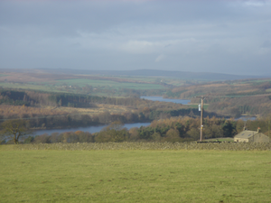
Reservoirs
The Washburn has been dammed to a series of four reservoirs, all built to supply water to the city of LeedsLeeds
Leeds is a city and metropolitan borough in West Yorkshire, England. In 2001 Leeds' main urban subdivision had a population of 443,247, while the entire city has a population of 798,800 , making it the 30th-most populous city in the European Union.Leeds is the cultural, financial and commercial...
. The lower three (Lindley Wood
Lindley Wood Reservoir
Lindley Wood Reservoir is located in the Washburn valley north of Otley in Yorkshire, England. It was built between 1869 and 1876. The capacity is about 750 million gallons.It was the first of a chain of four reservoirs built along the River Washburn...
, Swinsty
Swinsty Reservoir
Swinsty Reservoir is located in the Washburn valley north of Otley and west of Harrogate in Yorkshire, England. Construction began in 1871 and was completed in 1878. The capacity is about 866 million gallons, with a surface area of 63 hectares...
and Fewston
Fewston Reservoir
Fewston Reservoir is located in the Washburn valley north of Otley and west of Harrogate in Yorkshire, England. It was built in 1879. The capacity is about 3.5 million cubic metres. It can be found from the A59 road....
) were built at the end on the 19th century, while the fourth, Thruscross
Thruscross Reservoir
Thruscross Reservoir is the northernmost of four reservoirs in the Washburn valley, lying north of Otley and west of Harrogate in North Yorkshire, England. It can be found from the A59 road...
, was delayed until the 1960s. Fewston and Swinsty Reservoirs have a surface area of around 1.6km² and a combined length of 4.1km and Thackray Beck and Spinksburn Beck are major tributaries flowing into these reservoirs. Capelshaw Beck is the main tributary flowing into Thruscross reservoir.
Geology
Where the valley has not been flooded to make reservoirs, the sides are 'V' shaped. The valley floor consists of solid Millstone GritMillstone Grit
Millstone Grit is the name given to any of a number of coarse-grained sandstones of Carboniferous age which occur in the Northern England. The name derives from its use in earlier times as a source of millstones for use principally in watermills...
overlain with till drift. The drainage can be described as slowly-permeable and seasonally-waterlogged. The bedrock is covered with fine loam over clay soils and some peat soils at higher elevations on the fringe of the moorland.
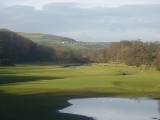
Geography
The river valley has grassland that is intensively managed for livestock. There are also a range of field sizes, bounded by stonewalls often reinforced with post and wire fencing plus some post and rail fencing. There are very large forestry conifer plantations around the reservoirs as well as at Beecroft Moor Plantation with conifer shelterbelts at Carlhow Ridge Plantation. Deciduous tree clumps can be found around settlements. Ancient Semi-Natural woodland can still be seen at Blubberhouses, Folly Hall Wood, Hanging Wood and Ellers Wood. There is evidence of past quarrying of local stone for buildings and walls. The river valley is crossed by the Harrogate Dales Way Link.Further reading
- The Washburn by Tom Bradley (published 1895, reprinted 1988)
- Washburn Valley Yesterday Vol II by David Alred. ISBN 1-85825-160-5