

River Rye, Yorkshire
Encyclopedia
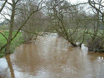
The River Rye is a river
in the English county of North Yorkshire
. It rises just south of the Cleveland Hills
, east of Osmotherley, and flows through Hawnby
, Rievaulx
, Helmsley
, Nunnington
, West and East Ness
, Butterwick, Brawby
, and Ryton, before joining the River Derwent
at 54°10′N 00°44′W near Malton
.
On some stretches of the river there is a conflict of interests between abstraction of water for economic purposes and the maintenance of a flow which is of sufficient quantity and quality to support the ecology of the area.
at Helmsley. In its eastward course from Helmsley the Rye receives the River Dove
from Farndale
which has previously added the Hodge Beck from Bransdale
. Hodge Beck is partly swallowed by the limestone aquifer in Kirkdale
and issues again further down the valley. Kirkbymoorside is on the River Dove
which, like Hodge Beck has a partly subterranean course. Rosedale
sends down the River Seven which comes by Sinnington to join the Rye. The steep sided Newtondale gives Pickering Beck which joins the Costa Beck before it enters the River Rye just before its mouth.
.
The Ness area is mainly rural with a few dispersed settlements. It has varied topography with the northern part of the area dominated by upland moors which are over 200 metres (656.2 ft) in height and part of the North York Moors
National Park. Here the land use is largely as managed grassland. Downstream, as the river approaches Rievaulx
and Helmsley
the land is around 100 metres (328.1 ft) in height and falls to 50 metres (164 ft) at East Ness
. In the lower part of the area the land use is a mixture of managed grassland and arable farming. There are also some pockets of forestry and woodland on the land close to the river.
Abstraction from the river is mainly to supply a fish farm at Harome and this water is returned to the river. There are two wastewater treatment works at Helmsley and Sproxton. The ecology and fisheries have a very high sensitivity to changers in water flow in this area.
, River Dove
(with Hodge Beck), River Seven, Costa Beck and Pickering Beck.
The market towns of Pickering
and Kirkbymoorside
are the largest settlements in the area. Otherwise the area is rural with a varied topography. To the north is the upland moorland of the North York moors with the valleys of Bransdale
, Farndale
, Rosedale
and Newtondale. Much of the moorland is over 300 metres (984.3 ft) in height with the highest point being 430 metres (1,410.8 ft). To the south of this upland the tributaries from the valleys converge and the land becomes flatter. It is mainly less than 100 metres (328.1 ft) in height. To the south west the Howe Bridge area covers the undulating landscape of the Howardian Hills.
The largest abstractions from the river are for fish farming. There are wastewater treatment works at Pickering, Harome and Kirkbymoorside.
Duncombe Park
is a National Nature Reserve (NNR) and the Howardian Hills
are an Area of Outstanding Natural Beauty.
and Kirkby Mills. Beneath the course of the Rye and its tributaries in the Vale of Pickering lie the lacustrine deposits from the last ice age. Newtondale was a melt water channel draining the North York Moors
at the end of the ice age and its valley is much more deeply incised than the flow of the present Pickering Beck would suggest.
is owned by the National Trust, though not open to visitors.
Rievaulx Abbey was established on the banks of the Rye on land given by Walter l'Espec of Helmsley and took its name from a literal translation of Rye Valley from the French. The monks of Rievaulx later diverted the river away from the abbey buildings.
On the Costa Beck
south of Pickering traces of a prehistoric settlement were excavated in the late 19th century.
River
A river is a natural watercourse, usually freshwater, flowing towards an ocean, a lake, a sea, or another river. In a few cases, a river simply flows into the ground or dries up completely before reaching another body of water. Small rivers may also be called by several other names, including...
in the English county of North Yorkshire
North Yorkshire
North Yorkshire is a non-metropolitan or shire county located in the Yorkshire and the Humber region of England, and a ceremonial county primarily in that region but partly in North East England. Created in 1974 by the Local Government Act 1972 it covers an area of , making it the largest...
. It rises just south of the Cleveland Hills
Cleveland Hills
The Cleveland Hills are a range of hills on the north-west edge of the North York Moors in North Yorkshire, England, overlooking Cleveland and Teesside. They lie entirely within the boundaries of the North York Moors National Park. Part of the long Cleveland Way National Trail runs along the...
, east of Osmotherley, and flows through Hawnby
Hawnby
Hawnby is a small crossroads village and civil parish in the English county of North Yorkshire. It is located some seven miles northwest of Helmsley....
, Rievaulx
Rievaulx
Rievaulx is a small village and civil parish near Helmsley in North Yorkshire and is located in what was the inner court of Rievaulx Abbey, close to the River Rye. The inner court of the monastery contained buildings such as the brewhouse, bakehouse and guesthouse. Its name originated as Rye +...
, Helmsley
Helmsley
Helmsley is a market town and civil parish in the Ryedale district of North Yorkshire, England. The town is located at the point where the valleys of Bilsdale and Ryedale leave the higher moorland and join the flat Vale of Pickering. It is situated on the River Rye and lies on the A170 road, east...
, Nunnington
Nunnington
Nunnington is a small village and civil parish in the Ryedale district of North Yorkshire, England. The river Rye runs through the village.Nunnington Hall is a Grade I listed mansion owned by the National Trust and open to the public. The parish church, dedicated to All Saints and St James, is also...
, West and East Ness
East Ness
East Ness and West Ness together form the English village of Ness, which sits on the south bank of the River Rye. The name Ness is believed to mean nose or headland in Medieval Norse, and Ness is the start of the hill that ultimately rises up to become Sutton Bank.The village of Ness is believed to...
, Butterwick, Brawby
Brawby
Brawby is a village and civil parish in the Ryedale district of North Yorkshire, England, situated at the confluence of the River Seven and the River Rye. According to the 2001 census Brawby had a population of 164.-Geography:...
, and Ryton, before joining the River Derwent
River Derwent, Yorkshire
The Derwent is a river in Yorkshire in the north of England. It is used for water abstraction, leisure and sporting activities and effluent disposal as well as being of significant importance as the site of several nature reserves...
at 54°10′N 00°44′W near Malton
Malton, North Yorkshire
Malton is a market town and civil parish in North Yorkshire, England. The town is the location of the offices of Ryedale District Council and has a population of around 4,000 people....
.
On some stretches of the river there is a conflict of interests between abstraction of water for economic purposes and the maintenance of a flow which is of sufficient quantity and quality to support the ecology of the area.
Course
The River Rye starts at Rye Head, close to the Cleveland Hills, then collects the River Seph which flows along Bilsdale receiving a tributary from Snilesworth Dale before it joins the Rye. It passes Rievaulx Abbey then enters the Vale of PickeringVale of Pickering
The Vale of Pickering is a low-lying flat area of land in North Yorkshire, England. It is drained by the River Derwent. The landscape is rural with scattered villages and small market towns. It has been inhabited continuously from the Mesolithic period...
at Helmsley. In its eastward course from Helmsley the Rye receives the River Dove
River Dove, North Yorkshire
The River Dove is a river the county of North Yorkshire, England, and is a tributary of the River Rye, itself a tributary of the River Derwent. It is the drainage basin of the moorland of Farndale, Stocksdale, Baysdale, Greenhow and Westerdale. It is formed by the confluence of Blakey Gill and West...
from Farndale
Farndale
Farndale is a valley located in the North York Moors National Park in North Yorkshire, England. The nearest town is Kirkbymoorside located some 5 miles to the south. Pickering is some 13 miles to the south east and Helmsley 12 miles to the south west. Farndale is surrounded by some of the most...
which has previously added the Hodge Beck from Bransdale
Bransdale
Bransdale is a valley running south through North Yorkshire, England, and part of the North York Moors National Park. Sandwiched between Bilsdale to the west and Farndale to the east, it is formed from the dales of Bransdale itself at the top of the valley, Sleightholmedale and Kirkdale...
. Hodge Beck is partly swallowed by the limestone aquifer in Kirkdale
Kirkdale, North Yorkshire
Kirkdale is a valley in North Yorkshire, England, which along with Sleightholmedale makes up the larger Bransdale and carries the Hodge Beck from its moorland source near Cockayne to the River Dove and onto the River Rye in the Vale of Pickering....
and issues again further down the valley. Kirkbymoorside is on the River Dove
River Dove, North Yorkshire
The River Dove is a river the county of North Yorkshire, England, and is a tributary of the River Rye, itself a tributary of the River Derwent. It is the drainage basin of the moorland of Farndale, Stocksdale, Baysdale, Greenhow and Westerdale. It is formed by the confluence of Blakey Gill and West...
which, like Hodge Beck has a partly subterranean course. Rosedale
Rosedale, North Yorkshire
Rosedale is a valley located almost in the centre of the North York Moors national park in North Yorkshire, England. The nearest town is Pickering located some 10 miles to the south. Rosedale is surrounded by some of the most beautiful moorland in England. To the north west sits Blakey Ridge...
sends down the River Seven which comes by Sinnington to join the Rye. The steep sided Newtondale gives Pickering Beck which joins the Costa Beck before it enters the River Rye just before its mouth.
Ness
Ness is the more upstream area and covers 240 km² (59,305.2 acre). It covers the River Rye and its tributaries from its source to its confluence with the River Dove near the village of East NessEast Ness
East Ness and West Ness together form the English village of Ness, which sits on the south bank of the River Rye. The name Ness is believed to mean nose or headland in Medieval Norse, and Ness is the start of the hill that ultimately rises up to become Sutton Bank.The village of Ness is believed to...
.
The Ness area is mainly rural with a few dispersed settlements. It has varied topography with the northern part of the area dominated by upland moors which are over 200 metres (656.2 ft) in height and part of the North York Moors
North York Moors
The North York Moors is a national park in North Yorkshire, England. The moors are one of the largest expanses of heather moorland in the United Kingdom. It covers an area of , and it has a population of about 25,000...
National Park. Here the land use is largely as managed grassland. Downstream, as the river approaches Rievaulx
Rievaulx
Rievaulx is a small village and civil parish near Helmsley in North Yorkshire and is located in what was the inner court of Rievaulx Abbey, close to the River Rye. The inner court of the monastery contained buildings such as the brewhouse, bakehouse and guesthouse. Its name originated as Rye +...
and Helmsley
Helmsley
Helmsley is a market town and civil parish in the Ryedale district of North Yorkshire, England. The town is located at the point where the valleys of Bilsdale and Ryedale leave the higher moorland and join the flat Vale of Pickering. It is situated on the River Rye and lies on the A170 road, east...
the land is around 100 metres (328.1 ft) in height and falls to 50 metres (164 ft) at East Ness
East Ness
East Ness and West Ness together form the English village of Ness, which sits on the south bank of the River Rye. The name Ness is believed to mean nose or headland in Medieval Norse, and Ness is the start of the hill that ultimately rises up to become Sutton Bank.The village of Ness is believed to...
. In the lower part of the area the land use is a mixture of managed grassland and arable farming. There are also some pockets of forestry and woodland on the land close to the river.
Abstraction from the river is mainly to supply a fish farm at Harome and this water is returned to the river. There are two wastewater treatment works at Helmsley and Sproxton. The ecology and fisheries have a very high sensitivity to changers in water flow in this area.
Howe Bridge
The Howe Bridge area covers 614 km² (151,722.6 acre). It consists of the River Rye from East Ness to its confluence with the River Derwent just beyond Howe Bridge. In this area the main tributaries of the Rye are the River RiccalRiver Riccal
The River Riccal is a river of North Yorkshire, England, lying within the North Yorks Moors National Park. It is a tributary of the River Rye, which in turn is a tributary of the River Derwent. The name originates in the fourteenth century as Ricolvegraines means Rye Calf, where Calf is a small...
, River Dove
River Dove, North Yorkshire
The River Dove is a river the county of North Yorkshire, England, and is a tributary of the River Rye, itself a tributary of the River Derwent. It is the drainage basin of the moorland of Farndale, Stocksdale, Baysdale, Greenhow and Westerdale. It is formed by the confluence of Blakey Gill and West...
(with Hodge Beck), River Seven, Costa Beck and Pickering Beck.
The market towns of Pickering
Pickering, North Yorkshire
Pickering is an ancient market town and civil parish in the Ryedale district of the county of North Yorkshire, England, on the border of the North York Moors National Park. It sits at the foot of the Moors, overlooking the Vale of Pickering to the south...
and Kirkbymoorside
Kirkbymoorside
Kirkbymoorside is a small market town and civil parish in the Ryedale district of North Yorkshire, England which lies approximately 25 miles north of York midway between Pickering and Helmsley, and has a population of approximately 3,000.-History:...
are the largest settlements in the area. Otherwise the area is rural with a varied topography. To the north is the upland moorland of the North York moors with the valleys of Bransdale
Bransdale
Bransdale is a valley running south through North Yorkshire, England, and part of the North York Moors National Park. Sandwiched between Bilsdale to the west and Farndale to the east, it is formed from the dales of Bransdale itself at the top of the valley, Sleightholmedale and Kirkdale...
, Farndale
Farndale
Farndale is a valley located in the North York Moors National Park in North Yorkshire, England. The nearest town is Kirkbymoorside located some 5 miles to the south. Pickering is some 13 miles to the south east and Helmsley 12 miles to the south west. Farndale is surrounded by some of the most...
, Rosedale
Rosedale, North Yorkshire
Rosedale is a valley located almost in the centre of the North York Moors national park in North Yorkshire, England. The nearest town is Pickering located some 10 miles to the south. Rosedale is surrounded by some of the most beautiful moorland in England. To the north west sits Blakey Ridge...
and Newtondale. Much of the moorland is over 300 metres (984.3 ft) in height with the highest point being 430 metres (1,410.8 ft). To the south of this upland the tributaries from the valleys converge and the land becomes flatter. It is mainly less than 100 metres (328.1 ft) in height. To the south west the Howe Bridge area covers the undulating landscape of the Howardian Hills.
The largest abstractions from the river are for fish farming. There are wastewater treatment works at Pickering, Harome and Kirkbymoorside.
Natural history
There are many sites in the Rye catchment area which have designated status.- Special Protection AreaSpecial Protection AreaA Special Protection Area or SPA is a designation under the European Union Directive on the Conservation of Wild Birds.Under the Directive, Member States of the European Union have a duty to safeguard the habitats of migratory birds and certain particularly threatened birds.Together with Special...
s provide protection to birds, their nests, eggs and habitats.(SPA's)
- Special Areas of Conservation contribute to biodiversity by maintaining and restoring habitats and species other than birds.(SAC's)
- Sites of Special Scientific Interest (SSSI’s)
| SSSI's | SAC's | SPA's |
|---|---|---|
| Farndale, Cropton Banks and Howlgate Head Woods, Newton Dale, The Ings ,Amotherby Duncombe Park, Ashberry and Reins Woods, Rievaulx Woods, Ryedale Windy Pits, North York Moors.. | North York Moors. | North York Moors. |
Duncombe Park
Duncombe Park
Duncombe Park is the seat of the Duncombe family whose senior member takes the title Baron Feversham. It is situated near Helmsley, North Yorkshire, England and stands in a commanding location above deeply incised meanders of the River Rye....
is a National Nature Reserve (NNR) and the Howardian Hills
Howardian Hills
The Howardian Hills form an Area of Outstanding Natural Beauty in North Yorkshire, England. located between the Yorkshire Wolds, the North York Moors National Park and the Vale of York. The AONB includes farmland, wooded rolling countryside, villages and historic houses with parkland...
are an Area of Outstanding Natural Beauty.
Geology
At source the River Rye and its tributaries run over Corallian limestone which outcrops on the hills surrounding the Vale of Pickering. In places this major aquifer is exposed in the river bed and water from the river is lost through swallow holes at KirkdaleKirkdale
Kirkdale is the name of several places in the United Kingdom:*Kirkdale, Merseyside, an area of Liverpool, England**Kirkdale **Kirkdale *Kirkdale, North Yorkshire, England...
and Kirkby Mills. Beneath the course of the Rye and its tributaries in the Vale of Pickering lie the lacustrine deposits from the last ice age. Newtondale was a melt water channel draining the North York Moors
North York Moors
The North York Moors is a national park in North Yorkshire, England. The moors are one of the largest expanses of heather moorland in the United Kingdom. It covers an area of , and it has a population of about 25,000...
at the end of the ice age and its valley is much more deeply incised than the flow of the present Pickering Beck would suggest.
History
The upland streams of the Rye and its tributaries have powered water mills for many centuries. There were certainly three at Pickering and others at Kirkby Mills, near Kirkbymoorside. A mill at BransdaleBransdale
Bransdale is a valley running south through North Yorkshire, England, and part of the North York Moors National Park. Sandwiched between Bilsdale to the west and Farndale to the east, it is formed from the dales of Bransdale itself at the top of the valley, Sleightholmedale and Kirkdale...
is owned by the National Trust, though not open to visitors.
Rievaulx Abbey was established on the banks of the Rye on land given by Walter l'Espec of Helmsley and took its name from a literal translation of Rye Valley from the French. The monks of Rievaulx later diverted the river away from the abbey buildings.
On the Costa Beck
Costa Beck
Costa Beck is a small river in the Ryedale district of North Yorkshire, England.The source of Costa Beck is Keld Head Spring to the west of Pickering. It is a tributary of the River Rye which joins the River Derwent, eventually flowing into the River Ouse at Barmby on the Marsh.Costa Beck was used...
south of Pickering traces of a prehistoric settlement were excavated in the late 19th century.