

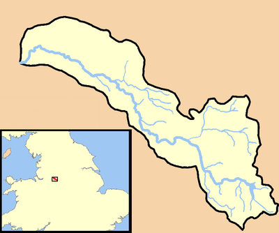
River Dean
Encyclopedia
Macclesfield Forest
Macclesfield Forest is an area of woodland, predominantly conifer plantation, located around south east of Macclesfield in the civil parish of Macclesfield Forest and Wildboarclough, in Cheshire, England. The existing woodland is the last substantial remnant of the Royal Forest of Macclesfield, a...
on the western edge of the Peak District
Peak District
The Peak District is an upland area in central and northern England, lying mainly in northern Derbyshire, but also covering parts of Cheshire, Greater Manchester, Staffordshire, and South and West Yorkshire....
foothills above the village of Rainow
Rainow
Rainow is a village and civil parish in the unitary authority of Cheshire East, located, mostly, on the eastern side of the River Dean valley next to the B5470 road, between Macclesfield and Kettleshulme in the ceremonial county of Cheshire, England. It straddles the eastern side of the Peak...
in north east Cheshire
Cheshire
Cheshire is a ceremonial county in North West England. Cheshire's county town is the city of Chester, although its largest town is Warrington. Other major towns include Widnes, Congleton, Crewe, Ellesmere Port, Runcorn, Macclesfield, Winsford, Northwich, and Wilmslow...
, England
England
England is a country that is part of the United Kingdom. It shares land borders with Scotland to the north and Wales to the west; the Irish Sea is to the north west, the Celtic Sea to the south west, with the North Sea to the east and the English Channel to the south separating it from continental...
.
Together with a number of tributary streams it is impounded by the dam at Lamaload. The river flows on to and passes through the village of Rainow, the town of Bollington
Bollington
Bollington is a small rural town and civil parish in the county of Cheshire, , England, in the unitary authority of Cheshire East. It is located east of Prestbury. In the Middle Ages it was part of the Earl of Chester's manor of Macclesfield., and the ancient parish of Prestbury...
, through the fields between Whiteley Green and Butley Town, Prestbury
Prestbury, Cheshire
Prestbury is a village, civil parish and ecclesiastical parish in the unitary authority of Cheshire East and the ceremonial county of Cheshire, England. Prestbury is a long, narrow parish covering 1,165 hectares to the west of the Peak Park foothills and to the east of the sandstone ridge which is...
, on through the grounds of Adlington Hall
Adlington Hall
Adlington Hall is a country house in Cheshire, England. The oldest part of the existing building, the Great Hall, was constructed between 1480 and 1505; the east wing was added in 1581. The Legh family has lived in the hall and in previous buildings on the same site since the early 14th century...
, thence to Deanwater, Handforth
Handforth
Handforth is a suburban area situated between Wilmslow, Heald Green, and Styal in Cheshire, England. Travelling south from Manchester, Handforth is the first place in Cheshire, although other areas nearer Manchester lie within the historic boundaries of the county.In the 1950s, two overspill...
, and finally it joins the River Bollin
River Bollin
The River Bollin is a major tributary of the River Mersey in the north-west of England.It rises in Macclesfield Forest at the western end of the Peak District, and can be seen in spring form, from the Buxton to Macclesfield road. The stream then descends the through Macclesfield and Wilmslow where...
between Wilmslow
Wilmslow
-Economy:Wilmslow is well known, like Alderley Edge, for having many famous residents, notably footballers, stars of Coronation Street and rich North West businessmen. The town is part of the so-called Golden Triangle in the north west together with Alderley Edge and Prestbury...
and Styal
Styal
Styal is a village in Cheshire East, England. It is on the River Bollin, near to the town of Wilmslow.Styal is a commuter village, with access to Manchester. The village is dominated by Quarry Bank Mill and much of its housing is the mill's estate. The mill and the surrounding country park are...
.
Below the dam there is a waterworks owned and managed by United Utilities
United Utilities
United Utilities Group PLC is the UK's largest listed water business. The Group owns and manages the regulated water and waste water network in the north west England, through it subsidiary United Utilities Water PLC , which is responsible for the vast majority of the group's assets and...
. The water saved in Lamaload Reservoir
Lamaload Reservoir
Lamaload Reservoir is a reservoir near Rainow, Cheshire, England . It lies in the South West Peak within the Peak District National Park, to the west of the Goyt Valley, and is fed by the River Dean. It serves Macclesfield, which lies to its west...
is used to supply Rainow, Bollington and other places. Next to the road bridge in Rainow village can be seen the early twentieth century waterworks built by Bollington Urban District Council. Shortly after passing Rainow the river flows north down the two mile long Ingersley Vale with Kerridge
Kerridge
Kerridge is a village in Cheshire, England, part of the parish of Bollington. Kerridge borders the neighbouring parish of Rainow.It gives its name to Kerridge Ridge – one of the western foothills of the Pennines – by which it stands. It is overlooked by the local landmark of White Nancy...
Hill to its western side. It is very quickly joined by the stream from Hayles Clough which rises to the east above Ginclough. From Ingersley Vale the river finds its way through Bollington, out of the hills and into the Cheshire Plain
Cheshire Plain
The Cheshire Plain is a relatively flat expanse of lowland situated almost entirely within the county of Cheshire in northwest England. It is bounded by the hills of North Wales to the west, and the Peak District of Derbyshire and North Staffordshire to the east and southeast...
at Lowerhouse (part of Bollington).
The historically notable section of these streams is between Ginclough and Lowerhouse. This length supported a large number of early watermill
Watermill
A watermill is a structure that uses a water wheel or turbine to drive a mechanical process such as flour, lumber or textile production, or metal shaping .- History :...
s and is recognised as one of the earliest developments in the English Industrial revolution
Industrial Revolution
The Industrial Revolution was a period from the 18th to the 19th century where major changes in agriculture, manufacturing, mining, transportation, and technology had a profound effect on the social, economic and cultural conditions of the times...
on the western side of the Pennines
Pennines
The Pennines are a low-rising mountain range, separating the North West of England from Yorkshire and the North East.Often described as the "backbone of England", they form a more-or-less continuous range stretching from the Peak District in Derbyshire, around the northern and eastern edges of...
. Some of the mills are described on the Bollington
Bollington
Bollington is a small rural town and civil parish in the county of Cheshire, , England, in the unitary authority of Cheshire East. It is located east of Prestbury. In the Middle Ages it was part of the Earl of Chester's manor of Macclesfield., and the ancient parish of Prestbury...
page.