

Ribnjak
Encyclopedia
Novi Sad
Novi Sad is the capital of the northern Serbian province of Vojvodina, and the administrative centre of the South Bačka District. The city is located in the southern part of Pannonian Plain on the Danube river....
, situated in the Serbia
Serbia
Serbia , officially the Republic of Serbia , is a landlocked country located at the crossroads of Central and Southeast Europe, covering the southern part of the Carpathian basin and the central part of the Balkans...
n province of Vojvodina
Vojvodina
Vojvodina, officially called Autonomous Province of Vojvodina is an autonomous province of Serbia. Its capital and largest city is Novi Sad...
.
Name
Its name is derived from the Serbian word "riba" ("fish" in English). In EnglishEnglish language
English is a West Germanic language that arose in the Anglo-Saxon kingdoms of England and spread into what was to become south-east Scotland under the influence of the Anglian medieval kingdom of Northumbria...
, word "ribnjak" means fishfarm.
Geography
The neighborhood is located on the DanubeDanube
The Danube is a river in the Central Europe and the Europe's second longest river after the Volga. It is classified as an international waterway....
river, in the Syrmia
Syrmia
Syrmia is a fertile region of the Pannonian Plain in Europe, between the Danube and Sava rivers. It is divided between Serbia in the east and Croatia in the west....
n part of Novi Sad, between Liberty Bridge and the Petrovaradin fortress
Petrovaradin fortress
Petrovaradin Fortress is a fortress in Novi Sad, Serbia. It is located in the province of Vojvodina, on the right bank of the Danube river. The cornerstone of the present-day southern part of the fortress was laid on October 18, 1692, by Charles Eugène de Croÿ...
, overlooking the Štrand
Štrand
Štrand is a popular beach on the Danube river in Novi Sad, Serbia. It is located near the Freedom Bridge, in the city quarter known as Liman....
and Liman neighborhood across the river.
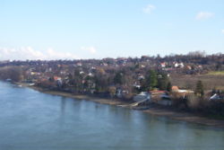
Ribnjak is situated on the slope
Slope
In mathematics, the slope or gradient of a line describes its steepness, incline, or grade. A higher slope value indicates a steeper incline....
hills between the Mišeluk
Mišeluk
Mišeluk is a neighborhood of the city of Novi Sad in Serbia.-Geography:Mišeluk is located in Syrmian part of Novi Sad, between Petrovaradin and Sremska Kamenica. Administratively, Mišeluk is regarded as part of Petrovaradin...
and Trandžament neighborhoods in the east, the river Danube
Danube
The Danube is a river in the Central Europe and the Europe's second longest river after the Volga. It is classified as an international waterway....
in the west, Sremska Kamenica
Sremska Kamenica
Sremska Kamenica is a town and urban neighborhood of Novi Sad, in Serbia.-Name:In Serbian, the town is known as Sremska Kamenica , in Croatian as Srijemska Kamenica, in Hungarian as Kamanc, and in German as Kamenitz.-Geography:The town is located in the Syrmia region, on the northern slopes of the...
in the south, and the Petrovaradin fortress
Petrovaradin fortress
Petrovaradin Fortress is a fortress in Novi Sad, Serbia. It is located in the province of Vojvodina, on the right bank of the Danube river. The cornerstone of the present-day southern part of the fortress was laid on October 18, 1692, by Charles Eugène de Croÿ...
in the north. Because the neighborhood is located on a slope, this area is subject to landslides, but they are not severe and are very slow in progress. There are two main roads in the neighborhood, the Lower and Upper Ribnjak Roads. In spring, when the waters of the Danube
Danube
The Danube is a river in the Central Europe and the Europe's second longest river after the Volga. It is classified as an international waterway....
river rise, the Lower Road and a few houses near the river get flooded.
On top of the hill (the border of Mišeluk and Trandžament neighborhoods) is a road which connects Sremska Kamenica
Sremska Kamenica
Sremska Kamenica is a town and urban neighborhood of Novi Sad, in Serbia.-Name:In Serbian, the town is known as Sremska Kamenica , in Croatian as Srijemska Kamenica, in Hungarian as Kamanc, and in German as Kamenitz.-Geography:The town is located in the Syrmia region, on the northern slopes of the...
and Petrovaradin
Petrovaradin
Petrovaradin , is part of the agglomeration of Novi Sad in Serbia...
. In the lower part of the neighborhood, a road links Donja Kamenica
Donja Kamenica
Donja Kamenica is a village in the municipality of Knjaževac, Serbia. According to the 2002 census, the village has a population of 360 people.-References:...
and Kamenički Park under the Liberty Bridge to Petrovaradin fortress
Petrovaradin fortress
Petrovaradin Fortress is a fortress in Novi Sad, Serbia. It is located in the province of Vojvodina, on the right bank of the Danube river. The cornerstone of the present-day southern part of the fortress was laid on October 18, 1692, by Charles Eugène de Croÿ...
and Varadin Bridge
Varadin Bridge
Varadin Bridge is a bridge on the Danube river in Novi Sad, Serbia. The bridge was built in 2000, after the previous bridge at this location was destroyed during NATO bombardment on April 1, 1999....
.
Features
Although it has a landslides and floods regularly, Ribnjak is attractive neighborhood, because it is a short drive from city centre of Novi Sad, Sremska KamenicaSremska Kamenica
Sremska Kamenica is a town and urban neighborhood of Novi Sad, in Serbia.-Name:In Serbian, the town is known as Sremska Kamenica , in Croatian as Srijemska Kamenica, in Hungarian as Kamanc, and in German as Kamenitz.-Geography:The town is located in the Syrmia region, on the northern slopes of the...
and Petrovaradin
Petrovaradin
Petrovaradin , is part of the agglomeration of Novi Sad in Serbia...
. It also has a beautiful scenic views at Novi Sad. There are approximately 500 people living in Ribnjak, all in residential houses.
Transportation
The upper part of Ribnjak is connected to the rest of the city by bus line 70, which goes from the railway station, through BanatićBanatic
Banatić is a quarter of the city of Novi Sad in Serbia. Its name means "a little Banat".-Borders:The southern border of Banatić is Bulevar kralja Petra I , the eastern border is Bulevar oslobođenja , the north-eastern borders are Bulevar Jaše Tomića and Kisačka ulica , the northern border is...
, Adamovićevo Naselje
Adamovicevo Naselje
Adamovićevo Naselje is a quarter of the city of Novi Sad in the Serbian province of Vojvodina.-Borders:The northern border of Adamovićevo Naselje is Futoška ulica , the eastern borders are Ulica Vojvode Knićanina and Ulica Kola srpskih sestara , the southern border is Bulevar cara Lazara...
, Liman, Stari Grad
Stari Grad, Novi Sad
Stari Grad is a neighborhood of the city of Novi Sad in the Serbian province of Vojvodina. It is the main part of Novi Sad, and it is also known as City Centre...
, Petrovaradin and up to the Sremska Kamenica Institute
Sremska Kamenica Institute
Sremska Kamenica Institute is one of the most modern and well known institutes and hospitals in Serbia and in former Yugoslavia; located in Sremska Kamenica, one of the neighborhoods of Novi Sad - the capital of the Serbian province of Vojvodina....
.