

Rialto Municipal Airport
Encyclopedia
General aviation
General aviation is one of the two categories of civil aviation. It refers to all flights other than military and scheduled airline and regular cargo flights, both private and commercial. General aviation flights range from gliders and powered parachutes to large, non-scheduled cargo jet flights...
airport located three miles (5 km) northwest of the central business district
Central business district
A central business district is the commercial and often geographic heart of a city. In North America this part of a city is commonly referred to as "downtown" or "city center"...
(CBD) of the city of Rialto
Rialto, California
-2010:The 2010 United States Census reported that Rialto had a population of 99,171. The population density was 4,434.1 people per square mile . The racial makeup of Rialto was 43,592 White, 16,236 African American, 1,062 Native American, 2,258 Asian, 361 Pacific Islander, 30,993 from other...
, in San Bernardino County
San Bernardino County, California
San Bernardino County is a county in the U.S. state of California. As of the 2010 census, the population was 2,035,210, up from 1,709,434 as of the 2000 census...
, California
California
California is a state located on the West Coast of the United States. It is by far the most populous U.S. state, and the third-largest by land area...
, USA
United States
The United States of America is a federal constitutional republic comprising fifty states and a federal district...
.
It is used exclusively by privately operated and chartered aircraft; no commercial airlines fly into this airport. The airport is located approximately eleven nautical miles northeast of Ontario International Airport
Ontario International Airport
LA/Ontario International Airport , formerly Ontario International Airport, is a public airport located east of the central business district of Ontario, a city in San Bernardino County, California, USA. This airport is owned and operated by the Los Angeles World Airports , an agency of the city...
and nine nautical miles west of San Bernardino International Airport
San Bernardino International Airport
San Bernardino International Airport is a public airport located two miles southeast of the central business district of San Bernardino, California, in San Bernardino County, California, USA. The airport covers and has one runway. It is currently a general aviation and cargo airport located on...
. The airport does not have a control tower and, on average, handles 82 operations a day.
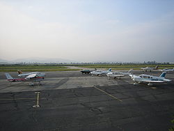
An FBO with a flight school and a separate helicopter flight school operate at the airport. There are several aviation related businesses on site. There is an air ambulance business in the southeast part of the airport.
Despite its above average size compared to other nearby airfields (Upland Cable Airport
Cable Airport
Cable Airport is a non-towered public-use airport located two miles northwest of the central business district of Upland, a city in San Bernardino County, California, United States. It is privately-owned by the Cable Land Company.-History:...
, Corona Municipal Airport
Corona Municipal Airport
Corona Municipal Airport , formerly L66, is a public airport located three miles northwest of Corona, serving Riverside County, California, United States.Although most U.S...
, El Monte Municipal Airport
El Monte Airport
El Monte Airport is a public airport located one mile north of the central business district of El Monte, a city in Los Angeles County, California, USA. The airport covers and has one runway.- External links :...
, Redlands Municipal Airport
Redlands Municipal Airport
Redlands Municipal Airport is a public airport located two miles northeast of Downtown Redlands, serving San Bernardino County, California, USA. This general aviation airport covers and has one runway....
and Hemet-Ryan Airport
Hemet-Ryan Airport
Hemet-Ryan Airport is a county-owned, public-use airport located three nautical miles southwest of the central business district of Hemet, in Riverside County, California, United States....
), Rialto is a relatively quiet and somewhat uneventful airport. This has led the city of Rialto to approve the closing of the airport by 2009/2010 for redevelopment of the property for other purposes driven by local real estate developers.
History
The land which is now Rialto Airport, about 40 acres (16.2 ha), was first purchased by Sam Miro in 1944. In 1966 the City of Rialto obtained the property while bringing the total land area to 60 acres (24.3 ha).In 1978 Art Scholl Aviation, founded by Art Scholl
Art Scholl
Arthur Everett Scholl was an American aerobatic pilot, aerial cameraman, flight instructor and educator based in Southern California. He died during filming of Top Gun when his Pitts S-2 camera plane never recovered from a flat spin and plunged into the Pacific Ocean...
, relocated to Rialto Airport from nearby Flabob Airport in Riverside, California.
Since 1984 the City of Rialto has accepted more than USD$15 million in federal aid for airport improvement and land purchases.
Facilities
Rialto Municipal Airport covers 600 acres (242.8 ha) and has two asphaltAsphalt
Asphalt or , also known as bitumen, is a sticky, black and highly viscous liquid or semi-solid that is present in most crude petroleums and in some natural deposits, it is a substance classed as a pitch...
paved runway
Runway
According to ICAO a runway is a "defined rectangular area on a land aerodrome prepared for the landing and take-off of aircraft." Runways may be a man-made surface or a natural surface .- Orientation and dimensions :Runways are named by a number between 01 and 36, which is generally one tenth...
s: 6/24 measuring 4500 by 100 ft (1,371.6 by 30.5 ) and 17/35 measuring 2650 by 50 ft (807.7 by 15.2 ).