Regions of the Northwest Territories
Encyclopedia
The regions of the Northwest Territories divide the Northwest Territories
into two census divisions by Statistics Canada
and five administrative regions
by the government of the Northwest Territories.

in 1999, there were five census divisions. Their boundaries were altered somewhat as part of the adjustment.
These regions are not to be confused with the former districts of the Northwest Territories.
Northwest Territories
The Northwest Territories is a federal territory of Canada.Located in northern Canada, the territory borders Canada's two other territories, Yukon to the west and Nunavut to the east, and three provinces: British Columbia to the southwest, and Alberta and Saskatchewan to the south...
into two census divisions by Statistics Canada
Statistics Canada
Statistics Canada is the Canadian federal government agency commissioned with producing statistics to help better understand Canada, its population, resources, economy, society, and culture. Its headquarters is in Ottawa....
and five administrative regions
Region
Region is most commonly found as a term used in terrestrial and astrophysics sciences also an area, notably among the different sub-disciplines of geography, studied by regional geographers. Regions consist of subregions that contain clusters of like areas that are distinctive by their uniformity...
by the government of the Northwest Territories.
Census divisions with their regional seats
- Fort Smith Region, Northwest TerritoriesFort Smith Region, Northwest TerritoriesFort Smith Region is one of Statistics Canada's two census divisions of the Northwest Territories, Canada. It contains more than 77 percent of the population and more than 54 percent of the land area of the Northwest Territories. Its main economic centre is the territorial capital of Yellowknife...
- Fort SmithFort Smith, Northwest TerritoriesFort Smith is a town in the South Slave Region of the Northwest Territories, Canada. It is located in the southeastern portion of the Northwest Territories, on the Slave River and adjacent to the NWT/Alberta border.-History:Fort Smith's history began because of the Slave River and the vital link... - Inuvik Region, Northwest TerritoriesInuvik Region, Northwest TerritoriesThe Inuvik Region is one of five administrative regions in the Northwest Territories. The region consists of eight communities with the regional office situated in Inuvik...
- InuvikInuvik, Northwest TerritoriesInuvik is a town in the Northwest Territories of Canada and is the administrative centre for the Inuvik Region.The population as of the 2006 Census was 3,484, but the two previous census counts show wide fluctuations due to economic conditions: 2,894 in 2001 and 3,296 in 1996...
Administrative regions with their regional seats
- Inuvik Region - InuvikInuvik, Northwest TerritoriesInuvik is a town in the Northwest Territories of Canada and is the administrative centre for the Inuvik Region.The population as of the 2006 Census was 3,484, but the two previous census counts show wide fluctuations due to economic conditions: 2,894 in 2001 and 3,296 in 1996...
- Sahtu RegionSahtu RegionThe Sahtu Region is one of five administrative regions in the Northwest Territories in Canada. The region consists of five communities with the regional office situated in Norman Wells. With the exception of Norman Wells the communities are predominately First Nations.-Communities:The Sahtu Region...
- Norman WellsNorman Wells, Northwest TerritoriesNorman Wells is the regional centre for the Sahtu Region of the Northwest Territories, Canada... - Dehcho RegionDehcho RegionThe Dehcho Region is one of five administrative regions in the Northwest Territories. The region consists of six communities with the regional office situated in Fort Simpson. All communities in the Dehcho are predominately First Nations.-Communities:...
- Fort SimpsonFort Simpson, Northwest TerritoriesFort Simpson is a village in the Dehcho Region of the Northwest Territories, Canada. The community is located on an island at the confluence of the Mackenzie and Liard Rivers... - North Slave RegionNorth Slave RegionThe North Slave Region is one of five administrative regions in the Northwest Territories. The region consists of eight communities with the regional offices situated in Behchoko and Yellowknife. With the exception of Yellowknife the communities are predominately First Nations.-Communities:The...
- BehchokoBehchoko, Northwest TerritoriesBehchokǫ̀ , officially the Tłı̨chǫ Community Government of Behchokǫ̀ is a community in the North Slave Region of the Northwest Territories, Canada. Behchokǫ̀ is located on the Yellowknife Highway , on the northwest tip of Great Slave Lake, approximately northwest of Yellowknife...
and YellowknifeYellowknife, Northwest TerritoriesYellowknife is the capital and largest city of the Northwest Territories , Canada. It is located on the northern shore of Great Slave Lake, approximately south of the Arctic Circle, on the west side of Yellowknife Bay near the outlet of the Yellowknife River... - South Slave RegionSouth Slave RegionThe South Slave Region is one of five administrative regions in the Northwest Territories. The region consists of seven communities with the regional offices situated in Fort Smith and Hay River. With the exception of Enterprise and Hay River the communities are predominately First...
- Fort SmithFort Smith, Northwest TerritoriesFort Smith is a town in the South Slave Region of the Northwest Territories, Canada. It is located in the southeastern portion of the Northwest Territories, on the Slave River and adjacent to the NWT/Alberta border.-History:Fort Smith's history began because of the Slave River and the vital link...
and Hay RiverHay River, Northwest TerritoriesHay River , known as "the Hub of the North," is a town in the Northwest Territories, Canada, located on the south shore of Great Slave Lake, at the mouth of the Hay River. The town is separated into two sections, a new town and an old town with the Hay River Airport between them...

Former census divisions
Prior to the division of the NWT and the creation of NunavutNunavut
Nunavut is the largest and newest federal territory of Canada; it was separated officially from the Northwest Territories on April 1, 1999, via the Nunavut Act and the Nunavut Land Claims Agreement Act, though the actual boundaries had been established in 1993...
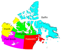
in 1999, there were five census divisions. Their boundaries were altered somewhat as part of the adjustment.
- Baffin Region, Northwest TerritoriesBaffin Region, Northwest TerritoriesThe Baffin Region was a region of the Northwest Territories, in use as an administrative and statistical division until the creation of Nunavut in 1999. The large majority of Baffin Region fell on the Nunavut side of the boundary and was reconstituted within the new territory as the Qikiqtaaluk...
- Fort Smith Region, Northwest Territories
- Inuvik Region, Northwest Territories
- Keewatin Region, Northwest TerritoriesKeewatin Region, Northwest TerritoriesThe Keewatin Region was a region of the Northwest Territories, in use as an administrative and statistical division until the creation of Nunavut in 1999...
- Kitikmeot Region, Northwest TerritoriesKitikmeot Region, Northwest TerritoriesThe Kitikmeot Region was part of the Northwest Territories until division in April 1999 when most of the region became part of Nunavut. It consisted of Victoria Island with the adjacent part of the mainland as far as the Boothia Peninsula, together with King William Island and the southern portion...
These regions are not to be confused with the former districts of the Northwest Territories.
See also
- Subdivisions of Canada

