
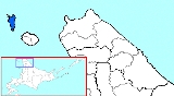
Rebun, Hokkaido
Encyclopedia
is a town
located in Rebun District
, Sōya
, Hokkaidō
, Japan
. The district and town both cover the island of the same name: Rebun Island
. Rebun island is famous for its alpine flowers.
in the Sea of Japan
. Rebun is located approximately 50 kilometres (31.1 mi) from Wakkanai
on mainland Hokkaidō and 10 kilometres (6.2 mi) northwest of Rishiri Island
. The entire island is part of the Rishiri-Rebun-Sarobetsu National Park
. Lake Kushu and Mount Rebun
(Rebun's highest point) are located in the town. Rebun is known as the northernmost town in Japan.
Rebun is well-known for its 300 species of alpine flowers, some of which are endemic to the island. For this it has earned the moniker the island of flowers. Such flowers include: .
of 3,194 and a density
of 39.3 persons per km². The total area is 81.33 km².
Towns of Japan
A town is a local administrative unit in Japan. It is a local public body along with prefecture , city , and village...
located in Rebun District
Rebun District, Hokkaido
is a district located in Sōya Subprefecture, Hokkaidō, Japan. The district and town both cover the island of the same name: Rebun Island.As of 2004, the district has an estimated population of 3,573 and a density of 43.93 persons per km². The total area is 81.33 km².-External links:...
, Sōya
Soya Subprefecture
is a subprefecture of Hokkaidō, Japan. Its population is estimated to be 77,500 as of July 31, 2004 and its area is 4,050.84 km². It is the northernmost subprefecture of Japan.Wakkanai Airport is located in Wakkanai...
, Hokkaidō
Hokkaido
, formerly known as Ezo, Yezo, Yeso, or Yesso, is Japan's second largest island; it is also the largest and northernmost of Japan's 47 prefectural-level subdivisions. The Tsugaru Strait separates Hokkaido from Honshu, although the two islands are connected by the underwater railway Seikan Tunnel...
, Japan
Japan
Japan is an island nation in East Asia. Located in the Pacific Ocean, it lies to the east of the Sea of Japan, China, North Korea, South Korea and Russia, stretching from the Sea of Okhotsk in the north to the East China Sea and Taiwan in the south...
. The district and town both cover the island of the same name: Rebun Island
Rebun Island
Rebun Island lies in the Sea of Japan off the northwestern tip of Hokkaidō, Japan. Rebun stretches 29 kilometers in the north-south direction and 8 kilometers east-west, covering about 80 square kilometers. The island is known for its alpine flowers and the 8-Hour Hiking Course which runs from one...
. Rebun island is famous for its alpine flowers.
Geography
The town covers the entire area of Rebun IslandRebun Island
Rebun Island lies in the Sea of Japan off the northwestern tip of Hokkaidō, Japan. Rebun stretches 29 kilometers in the north-south direction and 8 kilometers east-west, covering about 80 square kilometers. The island is known for its alpine flowers and the 8-Hour Hiking Course which runs from one...
in the Sea of Japan
Sea of Japan
The Sea of Japan is a marginal sea of the western Pacific Ocean, between the Asian mainland, the Japanese archipelago and Sakhalin. It is bordered by Japan, North Korea, Russia and South Korea. Like the Mediterranean Sea, it has almost no tides due to its nearly complete enclosure from the Pacific...
. Rebun is located approximately 50 kilometres (31.1 mi) from Wakkanai
Wakkanai, Hokkaido
is a city located in Sōya, Hokkaidō. It is the capital of Sōya Subprefecture and the northernmost city in Japan. It contains Japan's northernmost point, Cape Soya, from which the Russian island of Sakhalin can be seen....
on mainland Hokkaidō and 10 kilometres (6.2 mi) northwest of Rishiri Island
Rishiri Island
rises out of the Sea of Japan off the coast of Hokkaidō, Japan. The island is formed by the cone-shaped extinct volcanic peak of Mount Rishiri. Along with Rebun and the coastal area of Sarobetsu, Rishiri forms the Rishiri-Rebun-Sarobetsu National Park. The main industries of Rishiri are tourism and...
. The entire island is part of the Rishiri-Rebun-Sarobetsu National Park
Rishiri-Rebun-Sarobetsu National Park
is a national park on the Rishiri Island, Rebun Island, coasts of Wakkanai and Wakkasakanai and Sarobetsu Plain and the north-western edge of Hokkaidō, Japan.-External links:* http://www.biodic.go.jp/english/jpark/np/risiri_e.html...
. Lake Kushu and Mount Rebun
Mount Rebun
is the highest point on Rebun Island in Rebun, Hokkaidō, Japan. The mountain consists of marine sedimentary rocks from the Early Cretaceous period, 149–97 million years ago.-Climbing route:...
(Rebun's highest point) are located in the town. Rebun is known as the northernmost town in Japan.
Rebun is well-known for its 300 species of alpine flowers, some of which are endemic to the island. For this it has earned the moniker the island of flowers. Such flowers include: .
Demographics
As of December 31, 2007, the town has an estimated populationPopulation
A population is all the organisms that both belong to the same group or species and live in the same geographical area. The area that is used to define a sexual population is such that inter-breeding is possible between any pair within the area and more probable than cross-breeding with individuals...
of 3,194 and a density
Population density
Population density is a measurement of population per unit area or unit volume. It is frequently applied to living organisms, and particularly to humans...
of 39.3 persons per km². The total area is 81.33 km².
Sister cities
- Ohasama, IwateOhasama, Iwate, formerly an independent town, is now a district of Hanamaki in the heart of the Iwate Prefecture in the north of Honshū, Japan.As of November, 2005, the town had an estimated population of 6,766 people. The total area was 246.84 km² , formerly an independent town, is now a district of...
(Currently HanamakiHanamaki, Iwateis a city located in Iwate Prefecture, Japan. As of March 31, 2011, the city has an estimated total population of 102,455, with a household number of 35,831. Hanamaki is most famous as the birthplace of Kenji Miyazawa and for its onsen. The city recently celebrated the 50th anniversary since its...
) - Yutaka, HiroshimaYutaka, Hiroshimawas a town located in Toyota District, Hiroshima, Japan.On March 20, 2005 Kure, along with the towns of Ondo, Kurahashi and Kamagari, all from Aki District, and the towns of Yasuura and Toyohama, all from Toyota District, was merged into the expanded city of Kure and no longer exists as an...
(Currently KureKure, Hiroshimais a city in Hiroshima prefecture, Japan.As of October 1, 2010, the city has an estimated population of 240,820 and a population density of 681 persons per km². The total area is 353.74 km².- History :...
)