
Rand, New South Wales
Encyclopedia
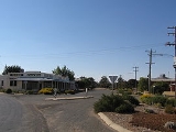
Rand is a town in the Riverina
district of New South Wales
, Australia
. It is located in the Urana Shire Local Government Area. At the 2006 census
, Rand had a population of 210.
It was formerly the terminus of the Rand railway line from Henty
, which opened in 1920 and closed in 1975.
Rand Post Office opened on 1 January 1926.
Riverina
The Riverina is an agricultural region of south-western New South Wales , Australia. The Riverina is distinguished from other Australian regions by the combination of flat plains, warm to hot climate and an ample supply of water for irrigation. This combination has allowed the Riverina to develop...
district of New South Wales
New South Wales
New South Wales is a state of :Australia, located in the east of the country. It is bordered by Queensland, Victoria and South Australia to the north, south and west respectively. To the east, the state is bordered by the Tasman Sea, which forms part of the Pacific Ocean. New South Wales...
, Australia
Australia
Australia , officially the Commonwealth of Australia, is a country in the Southern Hemisphere comprising the mainland of the Australian continent, the island of Tasmania, and numerous smaller islands in the Indian and Pacific Oceans. It is the world's sixth-largest country by total area...
. It is located in the Urana Shire Local Government Area. At the 2006 census
Census in Australia
The Australian census is administered once every five years by the Australian Bureau of Statistics. The most recent census was conducted on 9 August 2011; the next will be conducted in 2016. Prior to the introduction of regular censuses in 1961, they had also been run in 1901, 1911, 1921, 1933,...
, Rand had a population of 210.
It was formerly the terminus of the Rand railway line from Henty
Henty, New South Wales
Henty is a town on the Olympic Highway almost midway between Albury and Wagga Wagga in New South Wales, Australia. Henty is situated on the border of the South West Slopes and the Riverina districts. At the 2006 census, Henty had a population of 863 people....
, which opened in 1920 and closed in 1975.
Rand Post Office opened on 1 January 1926.
External links
- Urana Shire Council - Official site.
- Rand Railway Station