

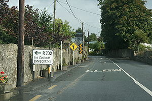
R702 road
Encyclopedia
The R702 road is a regional road
in Ireland
which runs west-east from the N10 at Coolgrange in County Kilkenny
through Gowran
before crossing into County Carlow
at Goresbridge
.
It continues to Borris, passes through the Blackstairs Mountains
via the Scullogue Gap into County Wexford
and continues east until it terminates at a junction with the N11 in Enniscorthy
.
The route is 49 km (30.4 mi) long.
Regional road
A regional road in Ireland is a class of road not forming a major route , but nevertheless forming a link in the national route network. There are over 11,600 kilometres of regional roads. Regional roads are numbered with three digit route numbers, prefixed by "R" A regional road in Ireland is a...
in Ireland
Republic of Ireland
Ireland , described as the Republic of Ireland , is a sovereign state in Europe occupying approximately five-sixths of the island of the same name. Its capital is Dublin. Ireland, which had a population of 4.58 million in 2011, is a constitutional republic governed as a parliamentary democracy,...
which runs west-east from the N10 at Coolgrange in County Kilkenny
County Kilkenny
County Kilkenny is a county in Ireland. It is part of the South-East Region and is also located in the province of Leinster. It is named after the city of Kilkenny. The territory of the county was the core part of the ancient Irish Kingdom of Osraige which in turn was the core of the Diocese of...
through Gowran
Gowran
Gowran is a village and former town in County Kilkenny, Ireland. Gowran Park race course is located nearby. Gowran is located on the N9 national primary road where it is crossed by the R702 regional road.-History:...
before crossing into County Carlow
County Carlow
County Carlow is a county in Ireland. It is part of the South-East Region and is also located in the province of Leinster. It is named after the town of Carlow, which lies on the River Barrow. Carlow County Council is the local authority for the county...
at Goresbridge
Goresbridge
Goresbridge is a village on the R702 regional road in east County Kilkenny, Ireland, on the River Barrow.-History:Goresbridge is named for the New Bridge built in 1756 by Colonel Ralph Gore the first and last Earl of Ross. The bridge remains of significant importance in the area for its...
.
It continues to Borris, passes through the Blackstairs Mountains
Blackstairs Mountains
The Blackstairs Mountains run roughly north/south along the border between County Carlow and County Wexford in Ireland.-See also:*List of mountains in Ireland...
via the Scullogue Gap into County Wexford
County Wexford
County Wexford is a county in Ireland. It is part of the South-East Region and is also located in the province of Leinster. It is named after the town of Wexford. In pre-Norman times it was part of the Kingdom of Uí Cheinnselaig, whose capital was at Ferns. Wexford County Council is the local...
and continues east until it terminates at a junction with the N11 in Enniscorthy
Enniscorthy
Enniscorthy is the second largest town in County Wexford, Ireland. The population of the town and environs is 9538. The Placenames Database of Ireland sheds no light on the origins of the town's name. It may refer either to the "Island of Corthaidh" or the "Island of Rocks". With a history going...
.
The route is 49 km (30.4 mi) long.