
R466 road
Encyclopedia

Regional road
A regional road in Ireland is a class of road not forming a major route , but nevertheless forming a link in the national route network. There are over 11,600 kilometres of regional roads. Regional roads are numbered with three digit route numbers, prefixed by "R" A regional road in Ireland is a...
in Ireland
Republic of Ireland
Ireland , described as the Republic of Ireland , is a sovereign state in Europe occupying approximately five-sixths of the island of the same name. Its capital is Dublin. Ireland, which had a population of 4.58 million in 2011, is a constitutional republic governed as a parliamentary democracy,...
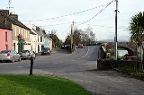
which runs southeast-northwest from the N7 at Birdhill
Birdhill
Birdhill is a village in North Tipperary, Ireland. It is in the barony of Owney and Arra and is part of the parish of Newport, Bridhill and Toor in the Roman Catholic Archdiocese of Cashel and Emly...
, County Tipperary
County Tipperary
County Tipperary is a county of Ireland. It is located in the province of Munster and is named after the town of Tipperary. The area of the county does not have a single local authority; local government is split between two authorities. In North Tipperary, part of the Mid-West Region, local...
to the R352 in East Clare.
After leaving the N7 at Birdhill it passes through Montpelier
Montpelier, County Limerick
Montpelier is a village in east County Limerick, Ireland, on the east bank of the River Shannon. It is connected to O'Briensbridge across the river in County Clare by a 14-arch stone bridge...
before crossing the River Shannon
River Shannon
The River Shannon is the longest river in Ireland at . It divides the west of Ireland from the east and south . County Clare, being west of the Shannon but part of the province of Munster, is the major exception...
at O'Briensbridge
O'Briensbridge
O'Brien's Bridge or O'Briensbridge is a village in east County Clare, Ireland, on the west bank of the River Shannon. The first bridge across the river here was built in 1506 by Turlough O'Brien, First Earl of Thomond and his brother, the Bishop of Killaloe.This 16th-century bridge was replaced or...
in County Clare
County Clare
-History:There was a Neolithic civilisation in the Clare area — the name of the peoples is unknown, but the Prehistoric peoples left evidence behind in the form of ancient dolmen; single-chamber megalithic tombs, usually consisting of three or more upright stones...
via a narrow 14-arch bridge. It veers northwest for the rest of the route, passing through Broadford and O'Callaghans mills
O'Callaghans mills
O'Callaghan's Mills is a community situated 27 km north of Limerick City in the County Clare, Ireland.The village takes its name from the O'Callaghan family who were large landowners in the area...
before terminating at a junction with the R352.
The route is 32 km (19.9 mi) long.