

Queen Anne Boulevard
Encyclopedia
Seattle, Washington
Seattle is the county seat of King County, Washington. With 608,660 residents as of the 2010 Census, Seattle is the largest city in the Northwestern United States. The Seattle metropolitan area of about 3.4 million inhabitants is the 15th largest metropolitan area in the country...
's Queen Anne Hill
Queen Anne, Seattle, Washington
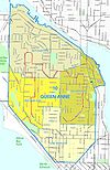
Queen Anne Hill is a neighborhood and geographic feature in Seattle, Washington, northwest of downtown. The neighborhood sits on the highest named hill in the city, with a maximum elevation of . It covers an area of , and has a population of about 28,000...
. It is a City of Seattle landmark. Authorized in 1907 and built from 1911 to 1916, it incorporates parts of 5th, 7th, 8th and 10th Avenues West; Bigelow Avenue North; West Blaine, McGraw, Wheeler, Fulton and Raye Streets; Smith, McGraw, and Wheeler Streets; and West McGraw and McGraw Places.
History
By 1906, the southern portions of Queen Anne Hill were already well connected to downtown Seattle by streetcar routes, but portions of the hill remained relatively inaccessible. The local community club approached the Parks BoardSeattle Parks and Recreation
Seattle Parks and Recreation is the department of government of the city of Seattle, Washington, responsible for maintaining the city's parks, open space, and community centers.The total area of the properties maintained by the department is over , which makes up approximately 11% of the total...
to propose a scenic route ringing the hill. The Park Board was not initially enthused. The proposed route was not part of the then recently developed "Olmsted
Olmsted Brothers
The Olmsted Brothers company was an influential landscape design firm in the United States, formed in 1898 by stepbrothers John Charles Olmsted and Frederick Law Olmsted, Jr. .-History:...
Plan" for Boulevards and Parkways, and the proposed route along standard city streets did not seem to offer the 150 feet (45.7 m) width that had been established as a standard for boulevards, to allow park-like landscaping.
On the other hand, nearly the entire route offered spectacular views. A deal was struck: the community would agree to pay for the private property that would have to be obtained to widen the streets (including land that would need to be filled or excavated); City Engineer R. H. Thomson
Reginald H. Thomson
Reginald Heber Thomson was a self-taught American civil engineer. He worked in Washington state, mainly in Seattle, where he became city engineer in 1892 and held the position for two decades. Alan J...
would be responsible for contracts and would deal with any necessary regrading of cross streets; the boulevard would eventually be transferred to the jurisdiction of the Park Department, which would landscape and surface the street. A 1907 ordinance authorized this plan and in 1908 it was incorporated into the Olmsted Plan, but in 1910 the project was still mired in lawsuits over land condemnation
Eminent domain
Eminent domain , compulsory purchase , resumption/compulsory acquisition , or expropriation is an action of the state to seize a citizen's private property, expropriate property, or seize a citizen's rights in property with due monetary compensation, but without the owner's consent...
.
The transfer to the Park Department occurred in 1911; work finally began, and was completed in 1916. Maple
Maple
Acer is a genus of trees or shrubs commonly known as maple.Maples are variously classified in a family of their own, the Aceraceae, or together with the Hippocastanaceae included in the family Sapindaceae. Modern classifications, including the Angiosperm Phylogeny Group system, favour inclusion in...
s, sycamore
Sycamore
Sycamore is a name which is applied at various times and places to three very different types of trees, but with somewhat similar leaf forms....
s, oak
Oak
An oak is a tree or shrub in the genus Quercus , of which about 600 species exist. "Oak" may also appear in the names of species in related genera, notably Lithocarpus...
s, elm
Elm
Elms are deciduous and semi-deciduous trees comprising the genus Ulmus in the plant family Ulmaceae. The dozens of species are found in temperate and tropical-montane regions of North America and Eurasia, ranging southward into Indonesia. Elms are components of many kinds of natural forests...
s, cottonwoods, chestnut
Chestnut
Chestnut , some species called chinkapin or chinquapin, is a genus of eight or nine species of deciduous trees and shrubs in the beech family Fagaceae, native to temperate regions of the Northern Hemisphere. The name also refers to the edible nuts they produce.-Species:The chestnut belongs to the...
s and other trees were planted along the route. This combination of roadway and park, vistas and improved transportation to privately owned land, was not a complete success. New construction impeded many of the views (as did the trees); tree roots attacked sewer lines; sidewalks heaved up to irregular angles as trees outgrew parking strips and shaded houses and yards more than was generally considered desirable. The Parks Department did approve some tree removals, always at the expense of the adjacent landowner.
In 1942 the roads (but not the landscaping) were transferred from Parks to the City Engineer's office. A 1952 proposal by the City Engineer and the Planning Commission to revert the route to "standard" street status was turned down by the City Council
Seattle City Council
The Seattle City Council is committed to ensuring that Seattle, Washington, is safe, livable and sustainable. Nine Councilmembers are elected to four-year terms in nonpartisan elections and represent the entire city, elected by all Seattle voters....
.
Current Use
Parks and Engineering continue each to have responsibilities relative to the boulevard, resulting in occasional inter-departmental squabbling. Nonetheless, the boulevard continues to be recognized as a vital part of the Queen Anne neighborhood, "The Crown of Queen Anne", an "urban trail and needed recreational amenity … appreciated by many Queen Anners and visitors for a diverse variety of uses" both for "automobile access to Upper Queen Anne neighborhoods" and as "a recreational and aesthetic amenity… used at all hours… The Boulevard offers shade in the summer, beautiful autumn color in the fall, and an open and sunny landscaped path in the winter."Every July beginning in 1986, the Queen Anne Helpline, a neighborhood social services agency, has sponsored the Crown of Queen Anne fun run on the boulevard. The race runs clockwise, starting near the Mt Pleasant Cemetery and finishing at Coe Elementary School.
As of 2008 recent, current, and proposed improvements for the boulevard include improving sidewalks and making sure that there is a sidewalk on at least one side of the boulevard throughout its length, adding signage that will indicate the boulevard route, creating "friendly" crossings where the boulevard intersects other major roads, better managing trees and other plants, adding "period sensitive and pedestrian scale" lighting to improve safety while still retaining the boulevard's historic character, removing encroachments, and better enforcing parking laws.