
Pupukea, Hawai'i
Encyclopedia

Census-designated place
A census-designated place is a concentration of population identified by the United States Census Bureau for statistical purposes. CDPs are delineated for each decennial census as the statistical counterparts of incorporated places such as cities, towns and villages...
(CDP) in the Koolauloa District on the Island of Oahu
Oahu
Oahu or Oahu , known as "The Gathering Place", is the third largest of the Hawaiian Islands and most populous of the islands in the U.S. state of Hawaii. The state capital Honolulu is located on the southeast coast...
, City & County of Honolulu
Honolulu County, Hawaii
The City and County of Honolulu is a consolidated city–county located in the U.S. state of Hawaii. The municipality and county includes both the urban district of Honolulu and the rest of the island of Oahu, as well as several minor outlying islands, including all of the Northwestern Hawaiian...
. In Hawaiian
Hawaiian language
The Hawaiian language is a Polynesian language that takes its name from Hawaii, the largest island in the tropical North Pacific archipelago where it developed. Hawaiian, along with English, is an official language of the state of Hawaii...
, pūpūkea means "white shell". As of the 2000 Census, the CDP had a total population of 4,250. The Koolauloa District ends at Waimea Bay, with the Waialua District extending south and westward.
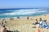
Pūpūkea is a popular area on Oahu's North Shore for living and for visiting. The best known surfing sites of Velzyland, Sunset (at Sunset Beach Park), Kammieland, Pūpūkea, Ehukai, Pipeline (these latter two off adjacent Ehukai Beach Park and Banzai Beach) and lesser breaks are arrayed off this shore. Popular diving areas known as Three Tables and Sharks Cove are located at Pūpūkea Beach Park. And, at the southwest end of Pūpūkea is Waimea Bay
Waimea Bay, Hawaii
Waimea Bay is located in Haleiwa on the North Shore of O‘ahu in the Hawaiian Islands at the mouth of the Waimea River. Waimea Valley extends behind Waimea Bay. Waimea means "Red Water" in Hawaiian.-History:...
, with one of the most popular beaches on the island forming the shore at Waimea Beach Park.
Popular residential areas here include the beach lots at Sunset Beach and the uplands of Pūpūkea. The biggest drawback to living in this part of the Island is the considerable driving distance to Honolulu
Honolulu, Hawaii
Honolulu is the capital and the most populous city of the U.S. state of Hawaii. Honolulu is the southernmost major U.S. city. Although the name "Honolulu" refers to the urban area on the southeastern shore of the island of Oahu, the city and county government are consolidated as the City and...
.
The U.S. postal code
Postal code
A postal code is a series of letters and/or digits appended to a postal address for the purpose of sorting mail. Once postal codes were introduced, other applications became possible.In February 2005, 117 of the 190 member countries of the Universal Postal Union had postal code systems...
for Pūpūkea and the communities of Waialee, Sunset Beach, Lihilani, Waimea, and Kawailoa is 96712.
Geography
Pūpūkea is located at 21°40'11" North, 158°2'58" West (21.669740, -158.049349), along Kamehameha Highway (State Rte. 83) west to southwest from Kawela Bay and northeast from Haleiwa.According to the United States Census Bureau
United States Census Bureau
The United States Census Bureau is the government agency that is responsible for the United States Census. It also gathers other national demographic and economic data...
, the CDP has a total area of 6.1 square miles (15.8 km²), of which, 3.4 square miles (8.8 km²) of it is land and 2.7 square miles (7 km²) of it is water. The total area is 44.17% water, a figure that can only be interpreted as that portion of the Pacific Ocean (possibly with Waimea Bay) included in the census tract.
Demographics
As of the 2000 Census, there were 4,250 people, 1,455 households, and 937 families residing in the CDP. The population densityPopulation density
Population density is a measurement of population per unit area or unit volume. It is frequently applied to living organisms, and particularly to humans...
was 1,250.5 people per square mile (482.6/km²). There were 1,690 housing units at an average density of 497.2 per square mile (191.9/km²). The racial makeup of the CDP was 55.95% White, 0.24% Black or African American, 0.66% Native American, 14.56% Asian, 6.52% Pacific Islander, 1.18% from other races, and 20.89% from two or more races. 8.38% of the population were Hispanic or Latino of any race.
There were 1,455 households out of which 32.8% had children under the age of 18 living with them, 48.0% were married couples
Marriage
Marriage is a social union or legal contract between people that creates kinship. It is an institution in which interpersonal relationships, usually intimate and sexual, are acknowledged in a variety of ways, depending on the culture or subculture in which it is found...
living together, 10.3% had a female householder with no husband present, and 35.6% were non-families. 18.7% of all households were made up of individuals and 3.4% had someone living alone who was 65 years of age or older. The average household size was 2.92 and the average family size was 3.35.
In the CDP the population was spread out with 23.6% under the age of 18, 10.1% from 18 to 24, 34.7% from 25 to 44, 24.3% from 45 to 64, and 7.3% who were 65 years of age or older. The median age was 34 years. For every 100 females there were 114.6 males. For every 100 females age 18 and over, there were 119.8 males.
The median income for a household in the CDP was $56,146, and the median income for a family was $62,375. Males had a median income of $41,015 versus $32,332 for females. The per capita income
Per capita income
Per capita income or income per person is a measure of mean income within an economic aggregate, such as a country or city. It is calculated by taking a measure of all sources of income in the aggregate and dividing it by the total population...
for the CDP was $25,682. 15.2% of the population and 11.4% of families were below the poverty line. Out of the total population, 15.8% of those under the age of 18 and 6.1% of those 65 and older were living below the poverty line.