
Preseli Pembrokeshire
Encyclopedia
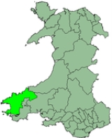
Preseli Pembrokeshire was one of six local government district
s of Dyfed
in West Wales
from 1974 to 1996. Until 1987 the name of the district was Preseli. The district took its name from the Preseli Hills
.
It was formed by the Local Government Act 1972
on April 1, 1974 from the northern part of the administrative county of Pembrokeshire
- specifically, the municipal borough
of Haverfordwest
, the urban district
s of Fishguard and Goodwick, Milford Haven
and Neyland
, and the rural district
s of Cemaes
and Haverfordwest. In 1981, a further 11 communities were transferred from South Pembrokeshire
district.
On April 1, 1996 the district was abolished by the Local Government (Wales) Act 1994
and merged into a reconstituted county of Pembrokeshire
.
Districts of Wales
In 1974, Wales was re-divided for local government purposes into thirty-seven districts. Districts were the second tier of local government introduced by the Local Government Act 1972, being subdivisions of the eight counties introduced at the same time...
s of Dyfed
Dyfed
Dyfed is a preserved county of Wales. It was created on 1 April 1974 under the terms of the Local Government Act 1972, and covered approximately the same geographic extent as the ancient Principality of Deheubarth, although excluding the Gower Peninsula and the area west of the River Tawe...
in West Wales
West Wales
West Wales is the western area of Wales.Some definitions of West Wales include only Pembrokeshire, Ceredigion and Carmarthenshire, an area which historically comprised the Welsh principality of Deheubarth., an area called "South West Wales" in the Nomenclature of Territorial Units for Statistics....
from 1974 to 1996. Until 1987 the name of the district was Preseli. The district took its name from the Preseli Hills
Preseli Hills
The Preseli Hills or Preseli Mountains are a range of hills in north Pembrokeshire, West Wales...
.
It was formed by the Local Government Act 1972
Local Government Act 1972
The Local Government Act 1972 is an Act of Parliament in the United Kingdom that reformed local government in England and Wales on 1 April 1974....
on April 1, 1974 from the northern part of the administrative county of Pembrokeshire
Pembrokeshire
Pembrokeshire is a county in the south west of Wales. It borders Carmarthenshire to the east and Ceredigion to the north east. The county town is Haverfordwest where Pembrokeshire County Council is headquartered....
- specifically, the municipal borough
Municipal borough
Municipal boroughs were a type of local government district which existed in England and Wales between 1835 and 1974, in Northern Ireland from 1840 to 1973 and in the Republic of Ireland from 1840 to 2002...
of Haverfordwest
Haverfordwest
Haverfordwest is the county town of Pembrokeshire, Wales and serves as the County's principal commercial and administrative centre. Haverfordwest is the most populous urban area in Pembrokeshire, with a population of 13,367 in 2001; though its community boundaries make it the second most populous...
, the urban district
Urban district
In the England, Wales and Ireland, an urban district was a type of local government district that covered an urbanised area. Urban districts had an elected Urban District Council , which shared local government responsibilities with a county council....
s of Fishguard and Goodwick, Milford Haven
Milford Haven
Milford Haven is a town and community in Pembrokeshire, Wales. It is situated on the north side of the Milford Haven Waterway, a natural harbour used as a port since the Middle Ages. The town was founded in 1790 on the north side of the Waterway, from which it takes its name...
and Neyland
Neyland
Neyland is a town in Pembrokeshire, Wales, lying on the River Cleddau and the upstream end of the Milford Haven estuary. The nearby Cleddau Bridge crosses the river, linking Neyland to Pembroke Dock.-History:...
, and the rural district
Rural district
Rural districts were a type of local government area – now superseded – established at the end of the 19th century in England, Wales, and Ireland for the administration of predominantly rural areas at a level lower than that of the administrative counties.-England and Wales:In England...
s of Cemaes
Cemaes Rural District
Cemaes Rural District was an administrative subdivision of Pembrokeshire, Wales. It was formed in 1934 by the amalgamation of St Dogmells RD and Llanfyrnach RD. It was administered from Newport, Pembrokeshire. It was abolished in 1974, when it was absorbed into the Preseli District of Dyfed....
and Haverfordwest. In 1981, a further 11 communities were transferred from South Pembrokeshire
South Pembrokeshire
South Pembrokeshire was one of six local government districts of Dyfed, Wales from 1974 to 1996.It was formed on April 1, 1974 under the Local Government Act 1972, from the following parts of the administrative county of Pembrokeshire:...
district.
On April 1, 1996 the district was abolished by the Local Government (Wales) Act 1994
Local Government (Wales) Act 1994
The Local Government Act 1994 is an Act of the Parliament of the United Kingdom which created the current local government structure in Wales of 22 unitary authority areas, referred to as principal areas in the Act, and abolished the previous two-tier structure of counties and districts...
and merged into a reconstituted county of Pembrokeshire
Pembrokeshire
Pembrokeshire is a county in the south west of Wales. It borders Carmarthenshire to the east and Ceredigion to the north east. The county town is Haverfordwest where Pembrokeshire County Council is headquartered....
.
See also
- Preseli HillsPreseli HillsThe Preseli Hills or Preseli Mountains are a range of hills in north Pembrokeshire, West Wales...
- Preseli Pembrokeshire (UK Parliament constituency)Preseli Pembrokeshire (UK Parliament constituency)Preseli Pembrokeshire is a constituency of the House of Commons of the Parliament of the United Kingdom. It elects one Member of Parliament by the first past the post system of election....
- Preseli Pembrokeshire (National Assembly for Wales constituency)