
Ponta do Sol, Cape Verde
Encyclopedia
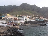
Ponta do Sol is a small fishing settlement situated in the northern part of the island municipality of Santo Antão, Cape Verde
. The city is the 12th largest in Cape Verde and is the seat of Ribeira Grande municipality. The city is located about north of Porto Novo
and northwest of Paul
and Ribeira Grande
and are linked with two main roads including one to Porto Novo. It sits near a cape of the same name and the mountains and the hills middle-class in Cape Verde.
The street system are grid runnind southwest to northeast and northwest to southeast. The urban area are within the harbor. Agriculture were the dominant industry until the 1990s and still a part of the population remains in agriculture. Businesses arrive along with the Agostinho Neto Airport
located about 400 m northwest is the westernmost airport in Africa
serving the islands of São Vicente
and Santiago
, the runway is only one kilometre. Four-storey hotels and apartments cover a stretch lies in the southern sprawl, restaurants, bars and a couple of more hotels are within its two main streets. Housing which led to a boom in population between 1990 and 2000 arrived in the 1990s and continues to this day. The bluffs and cliffs dominate the southwest.The city is growing with houses and tourist places.
Cape Verde
The Republic of Cape Verde is an island country, spanning an archipelago of 10 islands located in the central Atlantic Ocean, 570 kilometres off the coast of Western Africa...
. The city is the 12th largest in Cape Verde and is the seat of Ribeira Grande municipality. The city is located about north of Porto Novo
Porto Novo, Cape Verde
Porto Novo is the westernmost municipality in Cape Verde and all of Africa but not the mainland. It is a town and a municipality in the island of Santo Antão of Barlavento. It covers two-thirds of the island and is home to one-third of the population...
and northwest of Paul
Paul, Cape Verde
Paul is a municipality in the island of Santo Antão of the Barlavento group in Cape Verde. Together with Ribeira Grande, it covers one-third of the island and home to two-thirds of the population....
and Ribeira Grande
Ribeira Grande, Cape Verde
Ribeira Grande is a municipality on the island of Santo Antão of the Barlavento group in Cape Verde. It covers one-third of the island and is home to two-thirds of the population....
and are linked with two main roads including one to Porto Novo. It sits near a cape of the same name and the mountains and the hills middle-class in Cape Verde.
The street system are grid runnind southwest to northeast and northwest to southeast. The urban area are within the harbor. Agriculture were the dominant industry until the 1990s and still a part of the population remains in agriculture. Businesses arrive along with the Agostinho Neto Airport
Agostinho Neto Airport
The Agostinho Neto is an airport in Cape Verde located next to the town of Ponta do Sol, Cape Verde on the northern tip of the island of Santo Antão. The airport was named after Agostinho Neto, an Angolan politician....
located about 400 m northwest is the westernmost airport in Africa
Africa
Africa is the world's second largest and second most populous continent, after Asia. At about 30.2 million km² including adjacent islands, it covers 6% of the Earth's total surface area and 20.4% of the total land area...
serving the islands of São Vicente
São Vicente, Cape Verde
São Vicente , also Son Visent or Son Sent in Cape Verdean Creole, is one of the Barlavento islands of Cape Verde. It is located between the islands of Santo Antão and Santa Luzia, with the Canal de São Vicente separating it from Santo Antão.- Geography :The island is roughly rectangular in shape...
and Santiago
Santiago, Cape Verde
Santiago , or Santiagu in Cape Verdean Creole, is the largest island of Cape Verde, its most important agricultural centre and home to half the nation’s population. At the time of Darwin's voyage it was called St. Jago....
, the runway is only one kilometre. Four-storey hotels and apartments cover a stretch lies in the southern sprawl, restaurants, bars and a couple of more hotels are within its two main streets. Housing which led to a boom in population between 1990 and 2000 arrived in the 1990s and continues to this day. The bluffs and cliffs dominate the southwest.The city is growing with houses and tourist places.
Historical population
| Year | Population | Change | Density |
|---|---|---|---|
| 1990 (June 23, Census) | 1,505 | - | - |
| 2000 (June 16 June 2000 June 2000 was the sixth month of 2000. It began on a Thursday and ended after 30 days on a Friday.-Portal:Current events:This is an archived version of Wikipedia's Current events Portal from June 2000.... , Census) |
4,029 | - | - |
| 2005 (January 1, Computing) | 4,064 | - | - |