

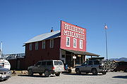
Polebridge, Montana
Encyclopedia
Unincorporated area
In law, an unincorporated area is a region of land that is not a part of any municipality.To "incorporate" in this context means to form a municipal corporation, a city, town, or village with its own government. An unincorporated community is usually not subject to or taxed by a municipal government...
in Flathead County
Flathead County, Montana
-National protected areas:* Pacific Northwest National Scenic Trail * Flathead National Forest * Glacier National Park * Kootenai National Forest * Lolo National Forest * Lost Trail National Wildlife Refuge-Demographics:...
, Montana
Montana
Montana is a state in the Western United States. The western third of Montana contains numerous mountain ranges. Smaller, "island ranges" are found in the central third of the state, for a total of 77 named ranges of the Rocky Mountains. This geographical fact is reflected in the state's name,...
, United States
United States
The United States of America is a federal constitutional republic comprising fifty states and a federal district...
, 35 miles (56 km) northwest of Columbia Falls
Columbia Falls, Montana
Columbia Falls is a city in Flathead County, Montana, United States. The population was 3,645 at the 2000 census.-Geography:Columbia Falls is located at ....
in the northwestern part of the state. This community is named for the log bridge that formerly connected the North Fork Road in Glacier National Park to Montana Secondary Highway 486, over the North Fork Flathead River
North Fork Flathead River
The North Fork Flathead River is a river flowing through British Columbia , Canada south into the U.S. state of Montana. It is one of the three primary forks of the Flathead River, a tributary of the Pend Oreille River, via Clark Fork. The river is sometimes considered the upper headwaters of the...
. Polebridge lies near the Canadian border.
See also
- Glacier View DamGlacier View DamGlacier View Dam was proposed in 1943 on the North Fork of the Flathead River, on the western border of Glacier National Park in Montana. The tall dam, to be designed and constructed by the U.S. Army Corps of Engineers in the canyon between Huckleberry Mountain and Glacier View Mountain, would...
, proposed in the 1940s, which would have inundated Polebridge