

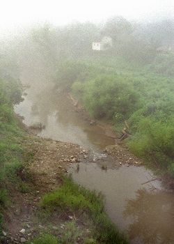
Pocatalico River
Encyclopedia
Tributary
A tributary or affluent is a stream or river that flows into a main stem river or a lake. A tributary does not flow directly into a sea or ocean...
of the Kanawha River
Kanawha River
The Kanawha River is a tributary of the Ohio River, approximately 97 mi long, in the U.S. state of West Virginia. The largest inland waterway in West Virginia, it has formed a significant industrial region of the state since the middle of the 19th century.It is formed at the town of Gauley...
, about 75 mi (120 km) long, in west-central West Virginia
West Virginia
West Virginia is a state in the Appalachian and Southeastern regions of the United States, bordered by Virginia to the southeast, Kentucky to the southwest, Ohio to the northwest, Pennsylvania to the northeast and Maryland to the east...
in the United States
United States
The United States of America is a federal constitutional republic comprising fifty states and a federal district...
. Via the Kanawha and Ohio
Ohio River
The Ohio River is the largest tributary, by volume, of the Mississippi River. At the confluence, the Ohio is even bigger than the Mississippi and, thus, is hydrologically the main stream of the whole river system, including the Allegheny River further upstream...
Rivers, it is part of the Mississippi River
Mississippi River
The Mississippi River is the largest river system in North America. Flowing entirely in the United States, this river rises in western Minnesota and meanders slowly southwards for to the Mississippi River Delta at the Gulf of Mexico. With its many tributaries, the Mississippi's watershed drains...
watershed
Drainage basin
A drainage basin is an extent or an area of land where surface water from rain and melting snow or ice converges to a single point, usually the exit of the basin, where the waters join another waterbody, such as a river, lake, reservoir, estuary, wetland, sea, or ocean...
.
The Pocatalico rises in Roane County
Roane County, West Virginia
As of the census of 2000, there were 15,446 people, 6,161 households, and 4,479 families residing in the county. The population density was 32 people per square mile . There were 7,360 housing units at an average density of 15 per square mile...
near the community of Looneyville
Looneyville, West Virginia
Looneyville is an unincorporated community on Flat Creek of the Pocatalico River in Roane County, West Virginia, United States. It is on West Virginia Route 36. The community is named for Robert Looney, a settler on the site in 1844. The post office was established in 1870....
and flows generally southwestwardly through southern Roane, northern Kanawha
Kanawha County, West Virginia
As of the census of 2000, there were 200,073 people, 86,226 households, and 55,960 families residing in the county. The population density was 222 people per square mile . There were 93,788 housing units at an average density of 104 per square mile...
and southeastern Putnam
Putnam County, West Virginia
As of the census of 2000, there were 51,589 people, 20,028 households, and 15,281 families residing in the county. The population density was 149 people per square mile . There were 21,621 housing units at an average density of 62 per square mile...
Counties, past the community of Sissonville
Sissonville, West Virginia
Sissonville is an unincorporated census-designated place in Kanawha County, West Virginia, along the Pocatalico River. The population was 4,028 at the 2010 census...
. It meets the Kanawha River at the town of Poca
Poca, West Virginia
Poca is a town in Putnam County, West Virginia, United States. The population was 974 at the 2010 census.-Geography:Poca is located at . It is sited at the confluence of the Kanawha River and the Pocatalico River....
.
The Pocatalico River and its watershed experienced severe flooding in March 1997, June 1998, and February 2001. The floods in 1997 and 1998 resulted in National Disaster declarations. The communities of Walton, Cicerone, Sissonville, and Millertown were most seriously impacted.
Variant names and spellings
The United States Board on Geographic NamesUnited States Board on Geographic Names
The United States Board on Geographic Names is a United States federal body whose purpose is to establish and maintain uniform usage of geographic names throughout the U.S. government.-Overview:...
settled on "Pocatalico River" as the stream's name in 1907. According to the Geographic Names Information System
Geographic Names Information System
The Geographic Names Information System is a database that contains name and locative information about more than two million physical and cultural features located throughout the United States of America and its territories. It is a type of gazetteer...
, it has also been known historically as:
|
|