
Plane table
Encyclopedia
A plane table is a device used in surveying and related disciplines to provide a solid and level surface on which to make field drawings, charts and maps. The early use of the name plain table reflected its simplicity and plainness rather than its flatness.
A brief description was also added to the 1591 edition of Digge's Pantometria. The first mention of the device in English was by Cyprian Lucar in 1590.
Some have credited Johann Richter, also known as Johannes Praetorius
, a Nuremberg
mathematician, in 1610 with the first plane table, but this appears to be incorrect.
The plane table became a popular instrument for surveying. Its use was widely taught. Interestingly, there were those who considered it a substandard instrument compared to such devices as the theodolite
, since it was relatively easy to use. By allowing the use of graphical methods rather than mathematical calculations, it could be used by those with less education than other instruments.
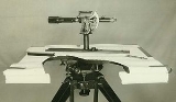
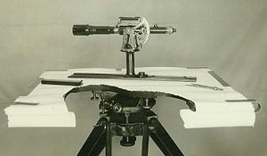 A plane table consists of a smooth table surface mounted on a sturdy base. The connection between the table top and the base permits one to level the table precisely, using bubble levels, in a horizontal plane. The base, a tripod, is designed to support the table over a specific point on land. By adjusting the length of the legs, one can bring the table level regardless of the roughness of the terrain.
with a telescopic sight
, can then be used to construct a line on the drawing that is in the direction of the object of interest.
By using the alidade as a surveying level, information on the topography of the site can be directly recorded on the drawing as elevations. Distances to the objects can be measured directly or by the use of stadia mark
s in the telescope of the alidade.
History
The earliest mention of a plane table dates to 1551 in Abel Foullon's "Usage et description de l'holomètre", published in Paris. However, since Foullon's description was of a complete, fully developed instrument, it must have been invented earlier.A brief description was also added to the 1591 edition of Digge's Pantometria. The first mention of the device in English was by Cyprian Lucar in 1590.
Some have credited Johann Richter, also known as Johannes Praetorius
Johannes Praetorius
Johann Richter or Johannes Praetorius was a Bohemian German mathematician and astronomer.- Life :...
, a Nuremberg
Nuremberg
Nuremberg[p] is a city in the German state of Bavaria, in the administrative region of Middle Franconia. Situated on the Pegnitz river and the Rhine–Main–Danube Canal, it is located about north of Munich and is Franconia's largest city. The population is 505,664...
mathematician, in 1610 with the first plane table, but this appears to be incorrect.
The plane table became a popular instrument for surveying. Its use was widely taught. Interestingly, there were those who considered it a substandard instrument compared to such devices as the theodolite
Theodolite
A theodolite is a precision instrument for measuring angles in the horizontal and vertical planes. Theodolites are mainly used for surveying applications, and have been adapted for specialized purposes in fields like metrology and rocket launch technology...
, since it was relatively easy to use. By allowing the use of graphical methods rather than mathematical calculations, it could be used by those with less education than other instruments.
Plane table construction
Use of a plane table
In use, a plane table is set over a point and brought to precise horizontal level. A drawing sheet is attached to the surface and an alidade is used to sight objects of interest. The alidade, in modern examples of the instrument a ruleRuler
A ruler, sometimes called a rule or line gauge, is an instrument used in geometry, technical drawing, printing and engineering/building to measure distances and/or to rule straight lines...
with a telescopic sight
Telescopic sight
A telescopic sight, commonly called a scope, is a sighting device that is based on an optical refracting telescope. They are equipped with some form of graphic image pattern mounted in an optically appropriate position in their optical system to give an accurate aiming point...
, can then be used to construct a line on the drawing that is in the direction of the object of interest.
By using the alidade as a surveying level, information on the topography of the site can be directly recorded on the drawing as elevations. Distances to the objects can be measured directly or by the use of stadia mark
Stadia mark
Stadia marks, also called stadia lines or stadia hairs, are crosshairs on the reticle of a theodolite or other surveying instrument that allow stadiametric rangefinding.-Etymology:...
s in the telescope of the alidade.
External links
- Telescopic Plane Table Alidade in the collection of the Smithsonian National Museum of American History. This image shows the bubble levels on the base.