

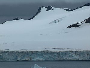
Petko Voyvoda Peak
Encyclopedia
Delchev Ridge
Delchev Ridge is the eastern ridge of the Tangra Mountains, Livingston Island and extends 10 km east-northeastward from Devin Saddle to Renier Point. The ridge is named in association with Delchev Peak.-Location:...
in Tangra Mountains
Tangra Mountains
Tangra Mountains form the principal mountain range of Livingston Island in the South Shetland Islands, Antarctica...
, Livingston Island in the South Shetland Islands
South Shetland Islands
The South Shetland Islands are a group of Antarctic islands, lying about north of the Antarctic Peninsula, with a total area of . By the Antarctic Treaty of 1959, the Islands' sovereignty is neither recognized nor disputed by the signatories and they are free for use by any signatory for...
, Antarctica, which surmounts Sopot Ice Piedmont
Sopot Ice Piedmont
Sopot Ice Piedmont is situated on Burgas Peninsula, Livingston Island, Antarctica, extending 7.5 km in east-west direction and 2.4 km in south-north direction...
to the northwest, and Pautalia Glacier
Pautalia Glacier
Pautalia Glacier is a glacier on Burgas Peninsula, Livingston Island, Antarctica bounded by Petko Voyvoda Peak to the west, Sozopol Gap to the northwest, Kaloyan Nunatak to the north and Shabla Knoll to the east. Extending 700 m in northwest-southeast direction and 1.1 km in southwest-northeast...
to the east.
The peak is named after Captain Petko Voyvoda
Petko Voyvoda
Petko Kiryakov Kaloyanov , better known as Captain Petko Voyvoda was a 19th-century Bulgarian hajduk leader and revolutionary who dedicated his life to the liberation of Bulgaria .Born in the Bulgarian village of Dogan Hisar, today Esimi in Aegean Thrace, today Evros Prefecture,...
(pseudonym of Petko Kiryakov, 1844–1900), leader of the Bulgarian liberation movement in Western Thrace
Western Thrace
Western Thrace or simply Thrace is a geographic and historical region of Greece, located between the Nestos and Evros rivers in the northeast of the country. Together with the regions of Macedonia and Epirus, it is often referred to informally as northern Greece...
and the Rhodope Mountains
Rhodope Mountains
The Rhodopes are a mountain range in Southeastern Europe, with over 83% of its area in southern Bulgaria and the remainder in Greece. Its highest peak, Golyam Perelik , is the seventh highest Bulgarian mountain...
.
Location
The peak is located at 62°37′49"S 59°52′24"W which is 1.1 km east of Elena PeakElena Peak
Elena Peak is a 700 m peak in Delchev Ridge, Tangra Mountains on Livingston Island in the South Shetland Islands...
, 1.33 km southeast of Paisiy Peak
Paisiy Peak
Paisiy Peak rises to approximately 550 m in the Delchev Ridge, Tangra Mountains, eastern Livingston Island in the South Shetland Islands, Antarctica surmounting Sopot Ice Piedmont to the north and east....
, 930 m southwest of Kaloyan Nunatak
Kaloyan Nunatak
Kaloyan Nunatak is a conspicuous nunatak in the Tangra Mountains. It is named after Czar Kaloyan of Bulgaria, 1197-1207 AD.Kaloyan Nunatak rises to approximately 400 m in Delchev Ridge, Tangra Mountains, on eastern Livingston Island in the South Shetland Islands, Antarctica...
from which the peak is separated by Sozopol Gap
Sozopol Gap
Sozopol Gap is a partly ice-covered, 500 m long saddle in Delchev Ridge, Tangra Mountains, eastern Livingston Island in the South Shetland Islands, Antarctica bounded to the southwest by Petko Voyvoda Peak and to the northeast by Kaloyan Nunatak...
, and 1.26 km west-southwest of Shabla Knoll
Shabla Knoll
Shabla Knoll rises to over in Delchev Ridge, Tangra Mountains, Livingston Island in the South Shetland Islands, Antarctica surmounting Sopot Ice Piedmont to the north and Pautalia Glacier to the southwest....
(Bulgarian mapping in 2005 and 2009 from the Tangra 2004/05
Tangra 2004/05
The Tangra 2004/05 Expedition was commissioned by the Antarctic Place-names Commission at the Ministry of Foreign Affairs of Bulgaria, managed by the Manfred Wörner Foundation, and supported by the Bulgarian Antarctic Institute, the Institute of Mathematics and Informatics at the Bulgarian Academy...
survey).
Maps
- L.L. Ivanov et al. Antarctica: Livingston Island and Greenwich Island, South Shetland Islands. Scale 1:100000 topographic map. Sofia: Antarctic Place-names Commission of Bulgaria, 2005.
- L.L. Ivanov. Antarctica: Livingston Island and Greenwich, Robert, Snow and Smith Islands. Scale 1:120000 topographic map. Troyan: Manfred Wörner Foundation, 2009. ISBN 978-954-92032-6-4