

Petit-Montrouge
Encyclopedia
Paris
Paris is the capital and largest city in France, situated on the river Seine, in northern France, at the heart of the Île-de-France region...
. It lies in the 14th Arrondissement
XIVe arrondissement
The 14th arrondissement of Paris is one of the 20 arrondissements of the capital city of France....
, in the south of the capital. It owes its name to the adjacent commune of Montrouge
Montrouge
Montrouge is a commune in the southern Parisian suburbs, located from the center of Paris, France. It is one of the most densely populated municipalities in Europe...
, of which it formed a part before 1860. It is familiar as the quartier Alésia, from the name of a street that bisects it and from the principal Métro
Paris Métro
The Paris Métro or Métropolitain is the rapid transit metro system in Paris, France. It has become a symbol of the city, noted for its density within the city limits and its uniform architecture influenced by Art Nouveau. The network's sixteen lines are mostly underground and run to 214 km ...
station that serves it, although the quartier Alésia does not exactly overlap the quartier du Petit-Montrouge.
Location
The quartier du Petit-Montrouge is delimited by Rue Daguerre and Boulevard Saint-Jacques to the north, by Rue de la Tombe-Issoire to the east, by Boulevard Romain Rolland to the south, and Avenue de la Porte de Châtillon and Rue des Plantes and Rue Gassendi to the west.It is bordered to the north by the quartier de Montparnasse
Montparnasse
Montparnasse is an area of Paris, France, on the left bank of the river Seine, centred at the crossroads of the Boulevard du Montparnasse and the Rue de Rennes, between the Rue de Rennes and boulevard Raspail...
, to the east by the quartier du Parc de Montsouris, to the south by the commune of Montrouge, and to the west by the quartier de Plaisance.
History
The quartier du Petit-Montrouge was created at the same time as the 14th Arrondissement in 1860, when Paris annexed a part of the commune of Montrouge. Montrouge was originally divided into two distinct sectors, Grand-Montrouge (corresponding to the current commune of Montrouge) and Petit-Montrouge, the church housing development launched around 1840, the centre of which is now called Place Michel Audiard. Still at this site today is a building in the French DirectoryFrench Directory
The Directory was a body of five Directors that held executive power in France following the Convention and preceding the Consulate...
architectural style, which was the old city hall annex of Montrouge (44, rue Du Couédic, 48.83006°N 2.33088°E).
Geography
From a topographical point of view, Petit-Montrouge is situated on a plateau atop the hillsides of the left bank of the Bièvre RiverBièvre River
The Bièvre is a 32.8 km long river of the Île-de-France région that flows into the Seine in Paris. The name translates to "Beaver River" in English....
. Overall it is flat. The centre of the quartier (as well as the centre of the arrondissement) is Place Hélène et Victor Basch, better known as Carrefour Alésia (48.827889°N 2.326816°E). That is the point of convergence of the old routes of Chartres
Chartres
Chartres is a commune and capital of the Eure-et-Loir department in northern France. It is located southwest of Paris.-Geography:Chartres is built on the left bank of the Eure River, on a hill crowned by its famous cathedral, the spires of which are a landmark in the surrounding country...
and Orléans
Orléans
-Prehistory and Roman:Cenabum was a Gallic stronghold, one of the principal towns of the Carnutes tribe where the Druids held their annual assembly. It was conquered and destroyed by Julius Caesar in 52 BC, then rebuilt under the Roman Empire...
, from which the flow of traffic is redistributed to the whole of the left bank of the capital by Rue d'Alésia, Avenue du Maine, and Avenue du Général Leclerc (which constitutes the backbone of the quartier). A network of more or less perpendicular streets serves the entire quartier, testifying to a belated urbanization.
Urban planning
The belated urbanization
Urbanization
Urbanization, urbanisation or urban drift is the physical growth of urban areas as a result of global change. The United Nations projected that half of the world's population would live in urban areas at the end of 2008....
of the quartier (after 1840), together with the availability of land, led to a great architectural diversity. The residential areas are composed of buildings of all styles. There is no great number of Haussmanian
Haussmann's renovation of Paris
Haussmann's Renovation of Paris, or the Haussmann Plan, was a modernization program of Paris commissioned by Napoléon III and led by the Seine prefect, Baron Georges-Eugène Haussmann, between 1853 and 1870...
edifices, the quartier having largely been untouched by Second French Empire
Second French Empire
The Second French Empire or French Empire was the Imperial Bonapartist regime of Napoleon III from 1852 to 1870, between the Second Republic and the Third Republic, in France.-Rule of Napoleon III:...
urban redevelopment. They are mostly found by the town hall and on Rue Alésia. Entirely Haussmanian streets, like Rue du Lunain, are rather rare. Façades in plaster are more common, testifying to the working class past of the quartier. Buildings of the 1930s are more present in the south, particularly in the ancient zone of fortifications. Finally the post-war architecture is also well-represented, for better and for worse. One of the characteristics of the quartier is the importance of the individual home. Many plots were built only in façade, leaving the place for city houses or artists' workshops, often adorned with private gardens, invisible from the street. This type of construction is also found in the dead end streets (the "villas"), occasionally with real architectural treasures. Certain streets, like Rue Bezout, form an authentic architectural museum offering to the visitor a variety of styles, sizes, eras of construction, and volumes. Concentrated in this quartier are also numerous Faubourg
Faubourg
Faubourg is an ancient French term approximating "suburb" . The earliest form is Forsbourg, derived from Latin foris, 'out of', and Vulgar Latin burgum, 'town' or 'fortress'...
ian buildings, predating the 1860 annexation, of one or two storeys, rare in the Parisian landscape. Office buildings are almost absent from this residential and shopping quartier, with the notable exception of the extreme south of the quartier, bordering on the commune of Montrouge.
Social composition
Until the 1960s it was a working class quartier, composed primarily of workmen, employees, merchants and members of the middle class. Since then the quartier has seen a rise in its standard of living, like Paris as a whole. It is today particularly sought-after because of its numerous stores, its parks, its atypical architecture, and the absence of large HLMHLM
HLM , French for "housing at moderated rents" or "rent-controlled housing", is a form of subsidised housing in France. There are approximately four million such residences, housing an estimated 12 million people — nearly one-fifth of the population of France...
(rent-controlled housing) complexes.
Curiosities and points of interest
There are no famous monuments in the quartier of Petit-Montrouge. The major tourist attraction is in fact underneath the quartier, since the section of the Catacombs of ParisCatacombs of Paris
The Catacombs of Paris or Catacombes de Paris are an underground ossuary in Paris, France. Located south of the former city gate , the ossuary holds the remains of about 6 million people and fills a renovated section of caverns and tunnels that are the remains of Paris' stone mines...
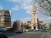
open to the public is between Place Denfert-Rochereau and Rue Rémy Dumoncel. The quartier is also known for the discount fashion retailers and wholesalers of Rue d'Alésia, with relatively attractive prices, concentrated in great number between Carrefour Alésia and Rue des Plantes. Carrefour Alésia, an obligatory point of passage between the southern suburbs and the centre of Paris, is also well known by drivers for its traffic congestion
Traffic congestion
Traffic congestion is a condition on road networks that occurs as use increases, and is characterized by slower speeds, longer trip times, and increased vehicular queueing. The most common example is the physical use of roads by vehicles. When traffic demand is great enough that the interaction...
.
The east sector of the quartier was recently made the object of a pilot development, named quartier vert, consisting principally of reducing automobile traffic, in favour of non-polluting modes of travel and highlighting the vegetational heritage. This experiment, subsequently extended to other quartiers of Paris, is diversely welcomed by residents, drivers, and retailers.
Public transportation
- RER BRER BThe RER B is one of the five lines in the RER rapid transit system serving :Paris, France.The line runs from the northern termini Aéroport Charles de Gaulle and Mitry-Claye to the southern termini Robinson and Saint-Rémy-lès-Chevreuse ....
: Denfert-RochereauDenfert-Rochereau (Paris Metro and RER)Denfert-Rochereau is a station on the Paris Métro and RER systems, in France.The RER station was previously a terminus of the Ligne de Sceaux, a surface suburban railway. It was rebuilt as an underground station, though the original station building survives and has been restored... - Paris MétroParis MétroThe Paris Métro or Métropolitain is the rapid transit metro system in Paris, France. It has become a symbol of the city, noted for its density within the city limits and its uniform architecture influenced by Art Nouveau. The network's sixteen lines are mostly underground and run to 214 km ...
, Line 4Paris Metro Line 4Line 4 is one of the sixteen lines of the Paris Métro rapid transit system. Situated entirely within the boundaries of the City of Paris, it connects Porte de Clignancourt in the north and Porte d'Orléans in the south, travelling across the heart of the city. As a result, it is sometimes called...
: Denfert-RochereauDenfert-Rochereau (Paris Metro and RER)Denfert-Rochereau is a station on the Paris Métro and RER systems, in France.The RER station was previously a terminus of the Ligne de Sceaux, a surface suburban railway. It was rebuilt as an underground station, though the original station building survives and has been restored...
, Mouton-DuvernetMouton-Duvernet (Paris Metro)Mouton-Duvernet is a small, typically Parisian metro station on line 4 in the 14th arrondissement.The line 4 platforms were opened on 30 October 1909 when the southern section of the line opened between Raspail and Porte d'Orléans. The name refers to the Rue Mouton-Duvernet, named after...
, AlésiaAlésia (Paris Metro)Alésia is a station of the Paris Métro on line 4 in the 14th arrondissement.The line 4 platforms were opened on 30 October 1909 when the southern section of the line opened between Raspail and Porte d'Orléans...
, and Porte d'OrléansPorte d'Orléans (Paris Metro)Porte d'Orléans is a station and southern terminus of line 4 of the Paris Métro and a stop on tramway line 3. It is situated in the 14th Arrondissement, in the quartier of Petit-Montrouge. A terminal loop is provided at the station for trains to turn around to return north towards Porte de... - Paris MétroParis MétroThe Paris Métro or Métropolitain is the rapid transit metro system in Paris, France. It has become a symbol of the city, noted for its density within the city limits and its uniform architecture influenced by Art Nouveau. The network's sixteen lines are mostly underground and run to 214 km ...
, Line 6Paris Metro Line 6Line 6 is one of the sixteen lines of the Paris Métro rapid transit system. Following a semi-circular route around the southern half of the city above boulevards formed by ancient city walls , it runs from Charles de Gaulle – Étoile in the west and Nation in the east.Opened between 1900 and 1906...
: Denfert-RochereauDenfert-Rochereau (Paris Metro and RER)Denfert-Rochereau is a station on the Paris Métro and RER systems, in France.The RER station was previously a terminus of the Ligne de Sceaux, a surface suburban railway. It was rebuilt as an underground station, though the original station building survives and has been restored... - TramwayTramways in ParisThe French region of Île-de-France, encompassing the capital city of Paris, currently has four tram lines, and is planning an additional line. Of the existing lines, three are operated by its public transport authority, RATP, which also operates the Paris Métro and most bus services. The fourth...
: Porte d'OrléansPorte d'Orléans (Paris Metro)Porte d'Orléans is a station and southern terminus of line 4 of the Paris Métro and a stop on tramway line 3. It is situated in the 14th Arrondissement, in the quartier of Petit-Montrouge. A terminal loop is provided at the station for trains to turn around to return north towards Porte de...