

Penrose, New Zealand
Encyclopedia
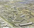
Penrose is an industrial suburb in Auckland City
, New Zealand
. It is located to the southeast of the city centre, at a distance of about nine kilometres, between the suburbs of Oranga
and Mount Wellington, and close to the Mangere Inlet
, an arm of the Manukau Harbour
. According to the 2001 census, Penrose has a population of only 573, due to the high intensity of industrial and commercial sites in the area.
In 2008, there were 44,975 employees and 4,998 businesses in the Penrose area, 14 per cent of Auckland City
's employment, making up seven per cent of its businesses. Of these, 16% were in manufacturing, 14% in wholesale trade, 10% in administrative and support services, 10% in professional, scientific and technical services, 8% in construction and 6% in transport, postal and warehousing business types.
 The area was first settled by Europeans as a military establishment during the New Zealand land wars
in the mid 1860s.
The railway line between Auckland and Onehunga running through Penrose (now known as the Onehunga Branch) was one of the first Government funded railways in New Zealand, being opened in 1873. It was built by the Auckland provincial government
.
Industry started to flourish in the area from the 1920s, due to its close connection to the main railway line and the main road (Great South Road
) with these important transport links later strengthened by the motorway (State Highway 1
) built following the same alignment in the 1950s. By this time, around 5,000 workers were employed in the suburb.
The new motorway and the move of industrial and manufacturing occupations out of older centres like the Auckland CBD
soon started a boom in the Penrose-Mount Wellington
area. Industry also successfully lobbied for state housing
to be built close by, to provide the new area with a supply of labour. To this day, the area remains almost exclusively industrial, with a mix of run-down areas and newly established sites.
. Mount Smart Stadium is also located in Penrose, as is the turnoff of the Onehunga Branch railway line from the North Auckland Line.
Auckland City
Auckland City was the city and local authority covering the Auckland isthmus and most of the islands of the Hauraki Gulf, in the North Island of New Zealand. On 1 November 2010 it was amalgamated into the wider Auckland Region under the authority of the new Auckland Council...
, New Zealand
New Zealand
New Zealand is an island country in the south-western Pacific Ocean comprising two main landmasses and numerous smaller islands. The country is situated some east of Australia across the Tasman Sea, and roughly south of the Pacific island nations of New Caledonia, Fiji, and Tonga...
. It is located to the southeast of the city centre, at a distance of about nine kilometres, between the suburbs of Oranga
Oranga
Oranga is a small residential suburb in Auckland, New Zealand. It is located nine kilometres to the southeast of the city centre, between the commercial suburbs of Te Papapa and Penrose to the south and east, and the residential suburbs of One Tree Hill and Onehunga to the north and south, with...
and Mount Wellington, and close to the Mangere Inlet
Mangere Inlet
Mangere Inlet is an arm of the Manukau Harbour, the southwestern of the two harbours of Auckland, New Zealand and itself an arm of the Tasman Sea. The inlet lies between the two cities of Auckland City and Manukau City and has a size of 6.6 km2 and a catchment of 34.5 km2, being considered to...
, an arm of the Manukau Harbour
Manukau Harbour
Manukau Harbour is the second largest natural harbour in New Zealand by area. It is located to the southwest of the Auckland isthmus, and is an arm of the Tasman Sea.-Geography:...
. According to the 2001 census, Penrose has a population of only 573, due to the high intensity of industrial and commercial sites in the area.
In 2008, there were 44,975 employees and 4,998 businesses in the Penrose area, 14 per cent of Auckland City
Auckland City
Auckland City was the city and local authority covering the Auckland isthmus and most of the islands of the Hauraki Gulf, in the North Island of New Zealand. On 1 November 2010 it was amalgamated into the wider Auckland Region under the authority of the new Auckland Council...
's employment, making up seven per cent of its businesses. Of these, 16% were in manufacturing, 14% in wholesale trade, 10% in administrative and support services, 10% in professional, scientific and technical services, 8% in construction and 6% in transport, postal and warehousing business types.
History
New Zealand land wars
The New Zealand Wars, sometimes called the Land Wars and also once called the Māori Wars, were a series of armed conflicts that took place in New Zealand between 1845 and 1872...
in the mid 1860s.
The railway line between Auckland and Onehunga running through Penrose (now known as the Onehunga Branch) was one of the first Government funded railways in New Zealand, being opened in 1873. It was built by the Auckland provincial government
Auckland Province
The Auckland Province was a province of New Zealand from 1853 until the abolition of provincial government in 1876.-Anniversary Day:...
.
Industry started to flourish in the area from the 1920s, due to its close connection to the main railway line and the main road (Great South Road
Great South Road, New Zealand
The Great South Road was the northern section of the earliest highway between Auckland and Wellington, in the North Island of New Zealand. Construction of the Great South Road began in 1861 during the New Zealand Wars...
) with these important transport links later strengthened by the motorway (State Highway 1
State Highway 1 (New Zealand)
State Highway 1 is the longest and most significant road in the New Zealand roading network, running the length of both main islands. It appears on road maps as SH 1 and on road signs as a white number 1 on a red shield, but it has the official designations SH 1N in the North Island, SH 1S in the...
) built following the same alignment in the 1950s. By this time, around 5,000 workers were employed in the suburb.
The new motorway and the move of industrial and manufacturing occupations out of older centres like the Auckland CBD
Auckland CBD
The Auckland CBD is the geographical and economic heart of the Auckland metropolitan area. Bounded by several major motorways and by the harbour coastline in the north, it is surrounded further out by mostly suburban areas...
soon started a boom in the Penrose-Mount Wellington
Mount Wellington, Auckland
-The volcano:Mount Wellington is a 137 metre volcanic peak located in the Auckland volcanic field of Auckland, New Zealand. It is the youngest onshore volcano of the Auckland volcanic field, having been formed by an eruption around 10,000 years ago...
area. Industry also successfully lobbied for state housing
State housing
State housing is the system of public housing offered to New Zealand residents on low to moderate incomes. Some 66,000 houses are managed by Housing New Zealand Corporation, most of which are owned by the government.-The Liberal Government:...
to be built close by, to provide the new area with a supply of labour. To this day, the area remains almost exclusively industrial, with a mix of run-down areas and newly established sites.
Education
Despite the low local population, Penrose is the site of the former Penrose High School, which in 2008 renamed itself One Tree Hill College, to shed the 'industrial' associations of the name. The school attracts many students from out of the suburb, many of its students coming from as far as 20 km away. Other State secondary schools serving the area include St Peter's CollegeSt Peter's College, Auckland
St Peter's College is a Catholic college for year 7 to 13 boys . The school, located in Auckland, is one of the largest Catholic schools in New Zealand and is an integrated school under an integration agreement entered into by the Catholic Bishop of Auckland and the Government of New Zealand in...
. Mount Smart Stadium is also located in Penrose, as is the turnoff of the Onehunga Branch railway line from the North Auckland Line.