
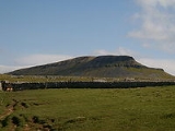
Pen-y-ghent
Encyclopedia
Pen-y-ghent is a fell
in the Yorkshire Dales
. It is one of the Yorkshire Three Peaks
, the other two being Ingleborough
and Whernside
. It lies some 3 km east of Horton in Ribblesdale
. The Pennine Way
links the summit to the village; the route is around 5 km in length as the Way curves initially to the north before turning east to reach the summit.
The more direct route that traverses the southern 'nose' of the hill is the route usually taken by the those attempting The Yorkshire Three Peaks
Challenge, as the walk is usually (but not exclusively) done in an anti-clockwise direction starting/finishing in Horton in Ribblesdale
. The other main hillwalking
route on the hill heads north from the summit to reach Plover hill before descending to join the bridleway that is Foxup Road.
In the Cumbric language
'Pen' presumably meant hill or head, but 'ghent' is more obscure. It could be taken to be edge or border. The name "Pen-y-ghent" could therefore mean Hill on the border. Alternatively, it could be mean 'wind' or 'winds' - from the closest Welsh language translation as 'gwynt'. Thus it might mean simply 'Head of the Winds'. It is also acceptable to write it as Pen y Ghent rather than Pen-y-Ghent.
Fell
“Fell” is a word used to refer to mountains, or certain types of mountainous landscape, in Scandinavia, the Isle of Man, and parts of northern England.- Etymology :...
in the Yorkshire Dales
Yorkshire Dales
The Yorkshire Dales is the name given to an upland area in Northern England.The area lies within the historic county boundaries of Yorkshire, though it spans the ceremonial counties of North Yorkshire, West Yorkshire and Cumbria...
. It is one of the Yorkshire Three Peaks
Yorkshire three peaks
The mountains of Whernside , Ingleborough and Pen-y-ghent are collectively known as the Three Peaks. The peaks, which form part of the...
, the other two being Ingleborough
Ingleborough
Ingleborough is the second highest mountain in the Yorkshire Dales. It is one of the Yorkshire Three Peaks, the other two being Whernside and Pen-y-ghent. Ingleborough is frequently climbed as part of the Yorkshire Three Peaks Challenge, which is a 24-mile circular challenge walk starting and...
and Whernside
Whernside
Whernside is a mountain in the Yorkshire Dales and is one of the Yorkshire Three Peaks, the other two being Ingleborough and Pen-y-ghent. It is the highest point in the ceremonial county of North Yorkshire,Mickle Fell in southern Teesdale is the highest point within the boundaries of the historic...
. It lies some 3 km east of Horton in Ribblesdale
Horton in Ribblesdale
Horton in Ribblesdale is a small village and civil parish in the Craven district of North Yorkshire, England. It is situated in Ribblesdale on the Settle–Carlisle Railway to the west of Pen-y-ghent....
. The Pennine Way
Pennine Way
The Pennine Way is a National Trail in England. The trail runs from Edale, in the northern Derbyshire Peak District, north through the Yorkshire Dales and the Northumberland National Park and ends at Kirk Yetholm, just inside the Scottish border. The path runs along the Pennine hills, sometimes...
links the summit to the village; the route is around 5 km in length as the Way curves initially to the north before turning east to reach the summit.
The more direct route that traverses the southern 'nose' of the hill is the route usually taken by the those attempting The Yorkshire Three Peaks
Yorkshire three peaks
The mountains of Whernside , Ingleborough and Pen-y-ghent are collectively known as the Three Peaks. The peaks, which form part of the...
Challenge, as the walk is usually (but not exclusively) done in an anti-clockwise direction starting/finishing in Horton in Ribblesdale
Horton in Ribblesdale
Horton in Ribblesdale is a small village and civil parish in the Craven district of North Yorkshire, England. It is situated in Ribblesdale on the Settle–Carlisle Railway to the west of Pen-y-ghent....
. The other main hillwalking
Hillwalking
In the British Isles, the terms hillwalking or fellwalking are commonly used to describe the recreational outdoor activity of walking on hills and mountains, often with the intention of visiting their summits...
route on the hill heads north from the summit to reach Plover hill before descending to join the bridleway that is Foxup Road.
In the Cumbric language
Cumbric language
Cumbric was a variety of the Celtic British language spoken during the Early Middle Ages in the Hen Ogledd or "Old North", or what is now northern England and southern Lowland Scotland, the area anciently known as Cumbria. It was closely related to Old Welsh and the other Brythonic languages...
'Pen' presumably meant hill or head, but 'ghent' is more obscure. It could be taken to be edge or border. The name "Pen-y-ghent" could therefore mean Hill on the border. Alternatively, it could be mean 'wind' or 'winds' - from the closest Welsh language translation as 'gwynt'. Thus it might mean simply 'Head of the Winds'. It is also acceptable to write it as Pen y Ghent rather than Pen-y-Ghent.
External links
- Computer generated summit panoramas Pen-y-ghent index
- Photos of Pen-y-ghent and surrounding area on geograph.org.uk