Pedra de Lume
Encyclopedia
{| border="0" cellpadding="2" cellspacing="0" align="right" width="300px" style="font-size: 98%; border: gray solid 1px; border-collapse: collapse;"
|---- bgcolor="#FFFFFF"efefef
| align="center" colspan="2" bgcolor="#d3d3d3"|Pedra de Lume
Pedra d' Lumi
|-----
! colspan="2" bgcolor="#FFFFFF" | |-----
! align="center" colspan="2" | Statistics
|---- bgcolor="#FFFFFF"
| Island
: || Sal
|---- bgcolor="#FFFFFF"
| Municipality: || Sal
|---- bgcolor="#FFFFFF"
| Parish: || Nossa Senhora das Dores
|---- bgcolor="#FFFFFF"
| Distance from the island capital: || about 5 km east of
Espargos
{| border="0" cellpadding="2" cellspacing="0" align="right" width="300px" style="font-size: 98%; border: gray solid 1px; border-collapse: collapse;"
|---- bgcolor="#FFFFFF"efefef
| align="center" colspan="2" bgcolor="#d3d3d3"|Pedra de Lume
Pedra d' Lumi
|-----
! colspan="2" bgcolor="#FFFFFF" | |-----
! align="center" colspan="2" | Statistics
|---- bgcolor="#FFFFFF"
| Island
: || Sal
|---- bgcolor="#FFFFFF"
| Municipality: || Sal
|---- bgcolor="#FFFFFF"
| Parish: || Nossa Senhora das Dores
|---- bgcolor="#FFFFFF"
| Distance from the island capital: || about 5 km east of
Espargos
{| border="0" cellpadding="2" cellspacing="0" align="right" width="300px" style="font-size: 98%; border: gray solid 1px; border-collapse: collapse;"
|---- bgcolor="#FFFFFF"efefef
| align="center" colspan="2" bgcolor="#d3d3d3"|Pedra de Lume
Pedra d' Lumi
|-----
! colspan="2" bgcolor="#FFFFFF" | |-----
! align="center" colspan="2" | Statistics
|---- bgcolor="#FFFFFF"
| Island
: || Sal
|---- bgcolor="#FFFFFF"
| Municipality: || Sal
|---- bgcolor="#FFFFFF"
| Parish: || Nossa Senhora das Dores
|---- bgcolor="#FFFFFF"
| Distance from the island capital: || about 5 km east of
Espargos||
|---- bgcolor="#FFFFFF"
| Altitude:
Lowest:
Centre:
Highest ||
Atlantic Ocean
about 5 m
Monte Grande
(around 350 m), northwest
|}
Pedra de Lume (Capeverdean Crioulo, ALUPEC
or ALUPEK: Pedra di Lumi, also in the Sal Crioulo) is a village in the eastern part of the island of Sal
. The village is about 5 km east of Espargos and is linked with a road linking to the island capital as well as other villages on the island. Pedra de Lume has been famous for its salt mines which began around the 18th century and is the most ancient, and the home of the first salt workers. Today it is only a small village with very few inhabitants.
The Pedra de Lume crater is around 500 m in radius and is an extinct volcano. The area features salt evaporation pond
s built over a natural salt lake
that formed through infiltration of water from the sea, since the base of the crater is below the sea level
. There is a cable car which used to carry the salt to the factory which is located by the shoreline where it had been shipping to other parts of the world, mainly Africa
. The salt extraction is currently inactive.
Some older houses are built with mud-brick and stone, the rest are concrete or sand with stone. Currently, more houses are built with brick and steel reinforced concrete. The population used to be a large percentage of miners, but currently is almost entirely made of fishermen, manufacturers and people working in the local tourism facilities. Part of the needed materials come from the island capital, the county capital and the diaspora. But other needs, electricity, communications and appliances are partially available in the area as well as phone lines since the mid to late-20th century.
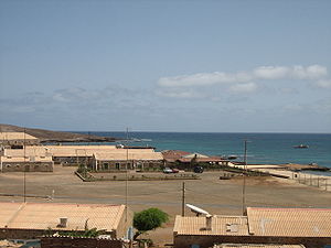
to the north and is the island's tallest mountain, the eastern portion of the island can be seen.
|---- bgcolor="#FFFFFF"efefef
| align="center" colspan="2" bgcolor="#d3d3d3"|Pedra de Lume
Pedra d' Lumi
|-----
! colspan="2" bgcolor="#FFFFFF" |

! align="center" colspan="2" | Statistics
|---- bgcolor="#FFFFFF"
| Island
Island
An island or isle is any piece of sub-continental land that is surrounded by water. Very small islands such as emergent land features on atolls can be called islets, cays or keys. An island in a river or lake may be called an eyot , or holm...
: || Sal
Sal, Cape Verde
Sal is an island in Cape Verde. It belongs to the northern group of islands, called Barlavento. The island is composed by a single administrative division, the Sal municipality. The island is home to Amílcar Cabral International Airport, the main airport of Cape Verde.- Geography :The island is...
|---- bgcolor="#FFFFFF"
| Municipality: || Sal
Sal, Cape Verde
Sal is an island in Cape Verde. It belongs to the northern group of islands, called Barlavento. The island is composed by a single administrative division, the Sal municipality. The island is home to Amílcar Cabral International Airport, the main airport of Cape Verde.- Geography :The island is...
|---- bgcolor="#FFFFFF"
| Parish: || Nossa Senhora das Dores
|---- bgcolor="#FFFFFF"
| Distance from the island capital: || about 5 km east of
Espargos
{| border="0" cellpadding="2" cellspacing="0" align="right" width="300px" style="font-size: 98%; border: gray solid 1px; border-collapse: collapse;"
|---- bgcolor="#FFFFFF"efefef
| align="center" colspan="2" bgcolor="#d3d3d3"|Pedra de Lume
Pedra d' Lumi
|-----
! colspan="2" bgcolor="#FFFFFF" |

! align="center" colspan="2" | Statistics
|---- bgcolor="#FFFFFF"
| Island
Island
An island or isle is any piece of sub-continental land that is surrounded by water. Very small islands such as emergent land features on atolls can be called islets, cays or keys. An island in a river or lake may be called an eyot , or holm...
: || Sal
Sal, Cape Verde
Sal is an island in Cape Verde. It belongs to the northern group of islands, called Barlavento. The island is composed by a single administrative division, the Sal municipality. The island is home to Amílcar Cabral International Airport, the main airport of Cape Verde.- Geography :The island is...
|---- bgcolor="#FFFFFF"
| Municipality: || Sal
Sal, Cape Verde
Sal is an island in Cape Verde. It belongs to the northern group of islands, called Barlavento. The island is composed by a single administrative division, the Sal municipality. The island is home to Amílcar Cabral International Airport, the main airport of Cape Verde.- Geography :The island is...
|---- bgcolor="#FFFFFF"
| Parish: || Nossa Senhora das Dores
|---- bgcolor="#FFFFFF"
| Distance from the island capital: || about 5 km east of
Espargos
{| border="0" cellpadding="2" cellspacing="0" align="right" width="300px" style="font-size: 98%; border: gray solid 1px; border-collapse: collapse;"
|---- bgcolor="#FFFFFF"efefef
| align="center" colspan="2" bgcolor="#d3d3d3"|Pedra de Lume
Pedra d' Lumi
|-----
! colspan="2" bgcolor="#FFFFFF" |

! align="center" colspan="2" | Statistics
|---- bgcolor="#FFFFFF"
| Island
Island
An island or isle is any piece of sub-continental land that is surrounded by water. Very small islands such as emergent land features on atolls can be called islets, cays or keys. An island in a river or lake may be called an eyot , or holm...
: || Sal
Sal, Cape Verde
Sal is an island in Cape Verde. It belongs to the northern group of islands, called Barlavento. The island is composed by a single administrative division, the Sal municipality. The island is home to Amílcar Cabral International Airport, the main airport of Cape Verde.- Geography :The island is...
|---- bgcolor="#FFFFFF"
| Municipality: || Sal
Sal, Cape Verde
Sal is an island in Cape Verde. It belongs to the northern group of islands, called Barlavento. The island is composed by a single administrative division, the Sal municipality. The island is home to Amílcar Cabral International Airport, the main airport of Cape Verde.- Geography :The island is...
|---- bgcolor="#FFFFFF"
| Parish: || Nossa Senhora das Dores
|---- bgcolor="#FFFFFF"
| Distance from the island capital: || about 5 km east of
Espargos||
|---- bgcolor="#FFFFFF"
| Altitude:
Lowest:
Centre:
Highest ||
Atlantic Ocean
Atlantic Ocean
The Atlantic Ocean is the second-largest of the world's oceanic divisions. With a total area of about , it covers approximately 20% of the Earth's surface and about 26% of its water surface area...
about 5 m
Monte Grande
Monte Grande (Sal), Cape Verde
Monte Grande is a mountain in the northern part of the island of Sal in Cape Verde.-Geography and Information:...
(around 350 m), northwest
|}
Pedra de Lume (Capeverdean Crioulo, ALUPEC
ALUPEC
The Alfabeto Unificado para a Escrita do Caboverdiano , commonly known as ALUPEC, is the alphabet that was officially recognized by the Cape Verdean government to write Cape Verdean Creole.- Description :...
or ALUPEK: Pedra di Lumi, also in the Sal Crioulo) is a village in the eastern part of the island of Sal
Sal, Cape Verde
Sal is an island in Cape Verde. It belongs to the northern group of islands, called Barlavento. The island is composed by a single administrative division, the Sal municipality. The island is home to Amílcar Cabral International Airport, the main airport of Cape Verde.- Geography :The island is...
. The village is about 5 km east of Espargos and is linked with a road linking to the island capital as well as other villages on the island. Pedra de Lume has been famous for its salt mines which began around the 18th century and is the most ancient, and the home of the first salt workers. Today it is only a small village with very few inhabitants.
Geography
There is little vegetation within the village and around it, with the surrounding area featuring a few green spots in sporadic areas. Fruits and vegetables and meat are mainly imported from other parts of Cape Verde that have better climate. The area has no farmlands. There is a small beach, and the rest of the coastline are jagged.The Pedra de Lume crater is around 500 m in radius and is an extinct volcano. The area features salt evaporation pond
Salt evaporation pond
Salt evaporation ponds, also called salterns or salt pans, are shallow artificial ponds designed to produce salts from sea water or other brines. The seawater or brine is fed into large ponds and water is drawn out through natural evaporation which allows the salt to be subsequently harvested...
s built over a natural salt lake
Salt lake
A salt lake or saline lake is a landlocked body of water which has a concentration of salts and other dissolved minerals significantly higher than most lakes . In some cases, salt lakes have a higher concentration of salt than sea water, but such lakes would also be termed hypersaline lakes...
that formed through infiltration of water from the sea, since the base of the crater is below the sea level
Sea level
Mean sea level is a measure of the average height of the ocean's surface ; used as a standard in reckoning land elevation...
. There is a cable car which used to carry the salt to the factory which is located by the shoreline where it had been shipping to other parts of the world, mainly Africa
Africa
Africa is the world's second largest and second most populous continent, after Asia. At about 30.2 million km² including adjacent islands, it covers 6% of the Earth's total surface area and 20.4% of the total land area...
. The salt extraction is currently inactive.
Some older houses are built with mud-brick and stone, the rest are concrete or sand with stone. Currently, more houses are built with brick and steel reinforced concrete. The population used to be a large percentage of miners, but currently is almost entirely made of fishermen, manufacturers and people working in the local tourism facilities. Part of the needed materials come from the island capital, the county capital and the diaspora. But other needs, electricity, communications and appliances are partially available in the area as well as phone lines since the mid to late-20th century.
Panorama
The panorama can see Monte GrandeMonte Grande (Sal), Cape Verde
Monte Grande is a mountain in the northern part of the island of Sal in Cape Verde.-Geography and Information:...
to the north and is the island's tallest mountain, the eastern portion of the island can be seen.

