

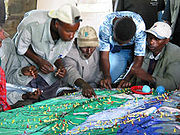
Participatory 3D Modelling (P3DM)
Encyclopedia
Awards
On November 5, 2007 at a ceremony which took place during the Global Forum 2007 at the Fondazione Giorgio Cini in Venice, Italy, the CTA-supported project Participatory 3D Modelling (P3DM) for Resource Use, Development Planning and Safeguarding Intangible Cultural Heritage in Fiji was granted the World Summit AwardWorld Summit Award
The World Summit Award is a global initiative for selecting and promoting the world's best electronic media and applications. It sees the bridging of the digital divide and narrowing of the "Content Gap" as its overall goal and, as of 2006, involves representatives from 168 countries on each...
2007 in the category e-culture. The product, based on the use of P3DM, has been considered as one of the 40 best practice examples of quality e-Content in the world
. The product has been delivered by the following organizations: Fiji Locally-Managed Marine Area (FLMMA) Network, WWF South Pacific Programme
World Wide Fund for Nature
The World Wide Fund for Nature is an international non-governmental organization working on issues regarding the conservation, research and restoration of the environment, formerly named the World Wildlife Fund, which remains its official name in Canada and the United States...
, Native Lands Trust Board, Secretariat of the Pacific Community
Secretariat of the Pacific Community
The Secretariat of the Pacific Community, or SPC , is a regional intergovernmental organisation whose membership includes both nations and territories...
, National Trust of Fiji
National Trust of Fiji
The National Trust of Fiji is a statutory organization in Fiji devoted to conservation of public resources. The trust was created in 1970 by the National Trust of Fiji Act.It administers parks and various historical sites...
, Lomaiviti Provincial Council and the Technical Centre for Agricultural and Rural Cooperation ACP-EU (CTA)
Technical Centre for Agricultural and Rural Cooperation ACP-EU (CTA)
The Technical Centre for Agricultural and Rural Cooperation ACP-EU was established in 1983 under the Lomé Convention between the ACP countries and EU member states...
.
External links
Networks- Open Forum on Participatory Geographic Information Systems and Technologies – a global network of PGIS/PPGIS practitioners with Spanish, Portuguese and French-speaking chapters.
- Indigenous Peoples of Africa Coordinating Committee (IPACC)
Organizations
- Integrated Approaches to Participatory Development (IAPAD) – Provides information and case studies on Participatory 3-Dimensional Modelling (P3DM) practice.
- The Philippine Association for Inter-Cultural Development (PAFID) uses Participatory 3D Modelling, GPS and GIS applications to support Indigenous Cultural Communities throughout the Philippines in claiming for their rights over ancestral domains.
- ERMIS Africa builds capacities among local communities and development practitioners in using Participatory Geo-spatial Information Management Technologies.
- The Technical Centre for Agricultural and Rural Cooperation ACP-EU (CTA)Technical Centre for Agricultural and Rural Cooperation ACP-EU (CTA)The Technical Centre for Agricultural and Rural Cooperation ACP-EU was established in 1983 under the Lomé Convention between the ACP countries and EU member states...
supports the dissemination of good PGIS practice, including P3DM in ACP countries.
Bibliography
Multimedia
- Collection of community mapping and participatory GIS multimedia
- Giving Voice to the Unspoken a 20-minute video production showing the hands-on aspects of Participatory 3D Modelling (P3DM).
- PGIS Channel on Vimeo, including several documentaries on P3DM in English, French, Spanish and Portuguese
See also
- Geographic information systems (GIS)Geographic Information SystemA geographic information system, geographical information science, or geospatial information studies is a system designed to capture, store, manipulate, analyze, manage, and present all types of geographically referenced data...
- NeogeographyNeogeographyNeogeography literally means "new geography" , and is commonly applied to the usage of geographical techniques and tools used for personal and community activities or for utilization by a non-expert group of users...
- Participatory GIS (PGIS)Participatory GISAs defined by the participants in the Mapping for Change International Conference which took place in Nairobi, Kenya in September 2005, Participatory GIS is an emergent practice in its own right; developing out of participatory approaches to planning and spatial information and communication...
- Public Participation GIS (PPGIS)
- Raised-relief mapRaised-relief mapA raised-relief map or terrain model is a three-dimensional representation, usually of terrain. When representing terrain, the elevation dimension is usually exaggerated by a factor between five and ten; this facilitates the visual recognition of terrain features.-History:In his 1665 paper for the...
- Traditional knowledge gisTraditional knowledge GISTraditional knowledge Geographic Information Systems are the data, techniques, and technologies designed to document and utilize local knowledges in communities around the world. Traditional knowledge is information that encompasses the experiences of a particular culture or society...