

Paro District
Encyclopedia
Dzongkhag
A dzongkhag is an administrative and judicial district of Bhutan. The twenty dzongkhags of Bhutan are further divided into 205 gewogs. Some larger dzongkhags have one or more of an intermediate judicial division, known as dungkhags , which themselves comprise two or more gewogs...
), valley, river and town (population 20,000) in Bhutan
Bhutan
Bhutan , officially the Kingdom of Bhutan, is a landlocked state in South Asia, located at the eastern end of the Himalayas and bordered to the south, east and west by the Republic of India and to the north by the People's Republic of China...
. It is one of the most historic valleys in Bhutan. Both trade goods and invading Tibet
Tibet
Tibet is a plateau region in Asia, north-east of the Himalayas. It is the traditional homeland of the Tibetan people as well as some other ethnic groups such as Monpas, Qiang, and Lhobas, and is now also inhabited by considerable numbers of Han and Hui people...
ans came over the pass at the head of the valley, giving Paro the closest cultural connection with Tibet of any Bhutanese district. The dominant language in Paro is Dzongkha, the national language.
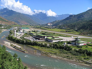
Paro contains the only active international airport
Airport
An airport is a location where aircraft such as fixed-wing aircraft, helicopters, and blimps take off and land. Aircraft may be stored or maintained at an airport...
in Bhutan, the Paro Airport
Paro Airport
Paro Airport is the only international airport of Bhutan. The airport is located from Paro in a deep valley on the bank of the Paro river at an elevation of ....
, a beautiful small green-roofed facility in a valley
Valley
In geology, a valley or dale is a depression with predominant extent in one direction. A very deep river valley may be called a canyon or gorge.The terms U-shaped and V-shaped are descriptive terms of geography to characterize the form of valleys...
, served only by Drukair (Bhutan's National Airline) from India
India
India , officially the Republic of India , is a country in South Asia. It is the seventh-largest country by geographical area, the second-most populous country with over 1.2 billion people, and the most populous democracy in the world...
and other countries in Southeast Asia
Southeast Asia
Southeast Asia, South-East Asia, South East Asia or Southeastern Asia is a subregion of Asia, consisting of the countries that are geographically south of China, east of India, west of New Guinea and north of Australia. The region lies on the intersection of geological plates, with heavy seismic...
.
Geography
Paro is bordered by Haa dzongkhag to the west, Tibet to the north, ThimphuThimphu
Thimphu also spelt Thimpu, is the capital and largest city of Bhutan. It is situated in the western central part of Bhutan and the surrounding valley is one of Bhutan's dzongkhags, the Thimphu District. The city became the capital of Bhutan in 1961...
to the east, and Chukha
Chukha
Chukha District is one of the 20 dzongkhag comprising Bhutan. The major town is Phuentsholing which is the gateway city along the sole road which connects India to western Bhutan . Chukha is the commercial and the financial capital of Bhutan...
dzongkhag to the south. Paro comprises ten gewog
Gewog
A gewog, or geog refers to a group of villages in Bhutan. Gewogs form a geographic administrative unit below dzongkhag districts , and above thromde municipalities. Bhutan comprises 205 gewogs, which average 230 km² in area...
s or counties or blocks:
- Doga GewogDoga GewogDokar Gewog is a gewog of Paro District, Bhutan. In 2002, the gewog had an area of 106.1 square kilometres and contains 21 villages and 327 households....
- Dopshari GewogDopshari GewogDopshari Gewog is a gewog of Paro District, Bhutan. In 2002, the gewog had an area of 36.7 square kilometres and contains 24 villages and 299 households....
- Doteng GewogDoteng GewogDoteng Gewog is a gewog of Paro District, Bhutan. The gewog in 2002 had an area of 193.1 square kilometres and contains eight villages and 143 households....
- Hungrel GewogHungrel GewogHungrel Gewog is a gewog of Paro District, Bhutan. In 2002, the gewog had an area of 3.6 square kilometres and contained 17 villages and 247 households....
- Lamgong GewogLamgong GewogLamgong Gewog is a gewog of Paro District, Bhutan. The gewog had an area of 48.8 square kilometres in 2002, and contained eight villages and 348 households....
- Lungnyi GewogLungnyi GewogLungnyi Gewog is a gewog of Paro District, Bhutan. In 2002, the gewog had an area of 59.7 square kilometres and contained seven villages and 265 households....
- Naja GewogNaja GewogNaja Gewog is a gewog of Paro District, Bhutan. In 2002, the gewog had an area of 151.8 square kilometres and contained 13 villages and 355 households....
- Shapa GewogShapa GewogShapa Gewog is a gewog of Paro District, Bhutan. In 2002, the gewog had an area of 76.4 square kilometres and contained 8 chewogs and 253 households....
- Tsento GewogTsento GewogTsento Gewog is a gewog of Paro District, Bhutan. In 2002, the gewog had an area of 575.1 square kilometres and contained 14 villages and 332 households....
- Wangchang GewogWangchang GewogWangchang Gewog is a gewog of Paro District, Bhutan. In 2002, the gewog had an area of 34.2 square kilometres and contained 7 chewogs and 278 households....
Northern Paro (Doteng
Doteng Gewog
Doteng Gewog is a gewog of Paro District, Bhutan. The gewog in 2002 had an area of 193.1 square kilometres and contains eight villages and 143 households....
, Tsento Gewog
Tsento Gewog
Tsento Gewog is a gewog of Paro District, Bhutan. In 2002, the gewog had an area of 575.1 square kilometres and contained 14 villages and 332 households....
s) contains part of Jigme Dorji National Park
Jigme Dorji National Park
The Jigme Dorji National Park, named after the late Jigme Dorji Wangchuk, is the second-largest National Park of Bhutan. It occupies almost the entire Gasa District, as well as the northern areas of Thimphu District, Paro District, Punakha, and Wangdue Phodrang Districts...
and the biological corridor connecting it to Torsa Strict Nature Reserve
Torsa Strict Nature Reserve
The Torsa Strict Nature Reserve in Bhutan covers in Haa District, occupying most of its area. It borders Sikkim and Tibet to the west and is connected to Jigme Dorji National Park via a "biological corridor." Torsa contains the westernmost temperate forests of Bhutan, from broadleaf forests to...
in neighboring Haa District
Haa District
This page is about the area Haa. For information about the airships, please see high-altitude airship.Haa District is one of the 20 dzongkhag or districts comprising Bhutan. Per the 2005 census, the population of Haa dzongkhag was 11,648, making it the second least populated dzongkhag in Bhutan...
.
Cultural sites
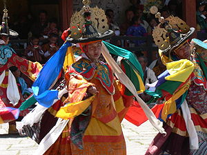
Important cultural sites of Paro include:- Taktshang, or Tiger's Nest, the most famous monastery and ancient highlights for the people of Bhutan. It was founded as a meditating cave by the famous saint Padmasambhava in the early 8th century upon subjugating a demon and forcing him to take an oath to be the local protector of the region towards the very end.
- Kyichu LhakhangKyichu LhakhangKyichu Lhakhang, is an important Himalayan Buddhist temple situated in Lamgong Gewog of Paro District in Bhutan.-History:...
, which along with Jambay LhakhangJambay LhakhangJambay Lhakhang, also spelled Jampey Lhakhang or Jampa, is located in Bumthang in Bhutan, and is said to be one of the 108 temples built by Tibetan King Songtsen Gampo in 659 AD on a single day, to pin down an ogress to earth forever.-Legend:...
in central Bhutan is the oldest temple in Bhutan, dating to the 7th century - Drukgyel DzongDrukgyel DzongDrukgyal Dzong was a fortress and Buddhist monastery, now in ruins, located in the upper part of the Paro valley in Paro District of Bhutan. The Dzong was probably built by Tenzin Drukdra in 1649 at the behest of Shabdrung Ngawang Namgyal to commemorate victory over an invasion from Tibet...
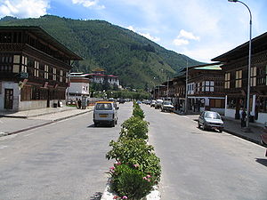
, at the upper end of the valley, built to protect against invading Tibetans, but in ruins since a fire in the 1950s. - Paro TownParo, Bhutan-History:Rinpung Dzong a fortress-monastery overlooking the Paro valley has a long history. A monastery was first built on the site by Padma Sambhava at the beginning of the tenth century, but it wasn't until 1646 that Ngawang Namgyal built a larger monastery on the old foundations, and for...
, the single market town in the dzonghag which is booming (by Bhutanese standards) due to an influx of tourist dollars. - Rinpung DzongRinpung DzongRinpung Dzong is a large Drukpa Kagyu Buddhist monastery and fortress in Paro District in Bhutan. It houses the district Monastic Body and government administrative offices of Paro Dzongkhag.-History:...
, also known as Paro Dzong, the massive fortress/monastery which is also the administrative center of the dzonkhag. Scenes from the movie Little BuddhaLittle BuddhaLittle Buddha is a 1994 feature film by Italian director Bernardo Bertolucci, starring Bridget Fonda and Keanu Reeves. Made by Bertolucci's regular partner, British producer Jeremy Thomas, it marked the team's return to the East after The Last Emperor....
were filmed in and around this dzong. - The National Museum of BhutanNational Museum of BhutanNational Museum of Bhutan is a cultural museum in the town of Paro in western Bhutan. Established in 1968, in the renovated ancient Ta-dzong building, above Rinpung Dzong under the command of His Majesty, the King Jigme Dorji Wangchuck, the third hereditary Monarch of Bhutan...
, where visitors can learn about the culture of Bhutan.