
Parkville, Missouri
Encyclopedia
Parkville is a city in Platte County
, Missouri
, United States
. The population was 4,059 at the 2000 census. Parkville is known for its antique shops, art galleries, and historic downtown. The city is home to Park University
and English Landing Park
.
who bought the steamboat landing concession on the Missouri River from the English Brothers in 1838 shortly after the Platte Purchase
from the Native Americans opened the area for settlement. He served as the town's first postmaster.
n 1845 he organized the Parkville Presbyterian Church which is still one of the town's largest congregations.
In 1853 he started the Industrial Luminary, a newspaper some believed to abolitionist. Park, however, owned slaves and termed the newspaper pro-commerce. Park generally believed that slavery in Kansas would be bad for his business interests there.
In 1854 while leading a trip up the Kansas River, he established the town of Polistra near the mouth of the Big Blue River.
Park's newspaper was raided by a pro-slavery mob on April 14, 1855, and the printing press was thrown in the Missouri River. Park was in Polistra at the time closing a deal to turn over the town into a newly named Boston, Kansas to be run by members of the abolitionist New England Emigrant Aid Company (who in turn would rename it Manhattan). The Parkville Luminary, a newspaper based on the original Luminary, began publishing again in 2004 and is circulated every Friday. The newspaper's first issue contained unpublished letters from Park's last issue and frequently reprints Park's own editorials from the original Luminary.
In 1859 he promoted the Parkville and Grand River Railroad to build the first bridge across the Missouri River. Park lost the battle to Kansas City when the Hannibal Bridge
opened in 1869 making it the dominant city in the region.
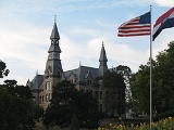
In 1875 he donated land for what would become Park University
on the bluffs above the Missouri River. His former home is a prominent part of the campus, visible from the entrance and serving as the school's alumni center.
Tom Watson
designed the National Golf Club of Kansas City
on the north edge of the city, an area that was voluntarily annexed into the city. The road passing it is called the Tom Watson Parkway, though generally referred to as Highway 45.
According to the United States Census Bureau
, the city has a total area of 7.5 square miles (19.3 km²), of which, 6.9 square miles (17.9 km²) of it is land and 0.6 square miles (1.5 km²) of it (7.50%) is water.
of 2000, there were 4,059 people, 1,510 households, and 1,060 families residing in the city. The population density
was 586.9 people per square mile (226.5/km²). There were 1,587 housing units at an average density of 229.5 per square mile (88.5/km²). The racial makeup of the city was 90.37% White, 4.71% African American, 0.52% Native American, 1.31% Asian, 0.96% Pacific Islander, 0.81% from other races
, and 1.33% from two or more races. Hispanic or Latino of any race were 2.27% of the population.
There were 1,510 households out of which 37.4% had children under the age of 18 living with them, 59.1% were married couples
living together, 7.7% had a female householder with no husband present, and 29.8% were non-families. 23.8% of all households were made up of individuals and 5.6% had someone living alone who was 65 years of age or older. The average household size was 2.54 and the average family size was 3.04.
In the city the population was spread out with 26.4% under the age of 18, 12.4% from 18 to 24, 29.9% from 25 to 44, 25.2% from 45 to 64, and 6.1% who were 65 years of age or older. The median age was 36 years. For every 100 females there were 95.0 males. For every 100 females age 18 and over, there were 93.5 males.
The median income for a household in the city was $68,600, and the median income for a family was $86,820. Males had a median income of $64,917 versus $31,740 for females. The per capita income
for the city was $33,119. About 5.0% of families and 6.5% of the population were below the poverty line, including 8.1% of those under age 18 and 3.3% of those age 65 or over.
Platte County, Missouri
As of the census of 2000, there were 73,781 people, 29,278 households, and 20,231 families residing in the county. The population density was 176 people per square mile . There were 30,902 housing units at an average density of 74 per square mile...
, Missouri
Missouri
Missouri is a US state located in the Midwestern United States, bordered by Iowa, Illinois, Kentucky, Tennessee, Arkansas, Oklahoma, Kansas and Nebraska. With a 2010 population of 5,988,927, Missouri is the 18th most populous state in the nation and the fifth most populous in the Midwest. It...
, United States
United States
The United States of America is a federal constitutional republic comprising fifty states and a federal district...
. The population was 4,059 at the 2000 census. Parkville is known for its antique shops, art galleries, and historic downtown. The city is home to Park University
Park University
Park University is an independent, private institution of higher education based in Parkville, Missouri. Established in 1875 as a small church-related college, it has now expanded into an electronic learning institution and provider of education courses for the U.S...
and English Landing Park
English Landing Park
English Landing Park is located along the Missouri river in Parkville, Missouri, United States. It includes a 3 mile jogging/biking trail that follows the river's edge, several shelters for picnics, a soccer field, a baseball diamond, volleyball courts, 2 playgrounds...
.
History
Parkville is named for George S. ParkGeorge S. Park
George Shepherd Park was a Texas War of Independence hero and founder of Parkville, Missouri, Park University and Manhattan, Kansas.-Biography:Park was born in Grafton, Vermont....
who bought the steamboat landing concession on the Missouri River from the English Brothers in 1838 shortly after the Platte Purchase
Platte Purchase
The Platte Purchase was a land acquisition in 1836 by the United States government from Native American tribes all of which was east bank lands along the Missouri River that added to the northwest corner of the state of Missouri. The area acquired is almost as large as the states of Delaware and...
from the Native Americans opened the area for settlement. He served as the town's first postmaster.
n 1845 he organized the Parkville Presbyterian Church which is still one of the town's largest congregations.
In 1853 he started the Industrial Luminary, a newspaper some believed to abolitionist. Park, however, owned slaves and termed the newspaper pro-commerce. Park generally believed that slavery in Kansas would be bad for his business interests there.
In 1854 while leading a trip up the Kansas River, he established the town of Polistra near the mouth of the Big Blue River.
Park's newspaper was raided by a pro-slavery mob on April 14, 1855, and the printing press was thrown in the Missouri River. Park was in Polistra at the time closing a deal to turn over the town into a newly named Boston, Kansas to be run by members of the abolitionist New England Emigrant Aid Company (who in turn would rename it Manhattan). The Parkville Luminary, a newspaper based on the original Luminary, began publishing again in 2004 and is circulated every Friday. The newspaper's first issue contained unpublished letters from Park's last issue and frequently reprints Park's own editorials from the original Luminary.
In 1859 he promoted the Parkville and Grand River Railroad to build the first bridge across the Missouri River. Park lost the battle to Kansas City when the Hannibal Bridge
Hannibal Bridge
The First Hannibal Bridge was the first bridge to cross the Missouri River and was to establish Kansas City, Missouri as a major city and rail center....
opened in 1869 making it the dominant city in the region.
In 1875 he donated land for what would become Park University
Park University
Park University is an independent, private institution of higher education based in Parkville, Missouri. Established in 1875 as a small church-related college, it has now expanded into an electronic learning institution and provider of education courses for the U.S...
on the bluffs above the Missouri River. His former home is a prominent part of the campus, visible from the entrance and serving as the school's alumni center.
Tom Watson
Tom Watson (golfer)
Thomas Sturges Watson is an American professional golfer who has played on the PGA Tour and now mostly on the Champions Tour....
designed the National Golf Club of Kansas City
National Golf Club of Kansas City
The National Golf Club of Kansas City is an exclusive golf club located in the Kansas City, Missouri, USA suburb of Parkville. The golf course was designed by champion golfer Tom Watson, a native of Kansas City, Missouri...
on the north edge of the city, an area that was voluntarily annexed into the city. The road passing it is called the Tom Watson Parkway, though generally referred to as Highway 45.
Geography
Parkville is located at 39°11′44"N 94°41′1"W (39.195602, -94.683636).According to the United States Census Bureau
United States Census Bureau
The United States Census Bureau is the government agency that is responsible for the United States Census. It also gathers other national demographic and economic data...
, the city has a total area of 7.5 square miles (19.3 km²), of which, 6.9 square miles (17.9 km²) of it is land and 0.6 square miles (1.5 km²) of it (7.50%) is water.
Demographics
As of the censusCensus
A census is the procedure of systematically acquiring and recording information about the members of a given population. It is a regularly occurring and official count of a particular population. The term is used mostly in connection with national population and housing censuses; other common...
of 2000, there were 4,059 people, 1,510 households, and 1,060 families residing in the city. The population density
Population density
Population density is a measurement of population per unit area or unit volume. It is frequently applied to living organisms, and particularly to humans...
was 586.9 people per square mile (226.5/km²). There were 1,587 housing units at an average density of 229.5 per square mile (88.5/km²). The racial makeup of the city was 90.37% White, 4.71% African American, 0.52% Native American, 1.31% Asian, 0.96% Pacific Islander, 0.81% from other races
Race (United States Census)
Race and ethnicity in the United States Census, as defined by the Federal Office of Management and Budget and the United States Census Bureau, are self-identification data items in which residents choose the race or races with which they most closely identify, and indicate whether or not they are...
, and 1.33% from two or more races. Hispanic or Latino of any race were 2.27% of the population.
There were 1,510 households out of which 37.4% had children under the age of 18 living with them, 59.1% were married couples
Marriage
Marriage is a social union or legal contract between people that creates kinship. It is an institution in which interpersonal relationships, usually intimate and sexual, are acknowledged in a variety of ways, depending on the culture or subculture in which it is found...
living together, 7.7% had a female householder with no husband present, and 29.8% were non-families. 23.8% of all households were made up of individuals and 5.6% had someone living alone who was 65 years of age or older. The average household size was 2.54 and the average family size was 3.04.
In the city the population was spread out with 26.4% under the age of 18, 12.4% from 18 to 24, 29.9% from 25 to 44, 25.2% from 45 to 64, and 6.1% who were 65 years of age or older. The median age was 36 years. For every 100 females there were 95.0 males. For every 100 females age 18 and over, there were 93.5 males.
The median income for a household in the city was $68,600, and the median income for a family was $86,820. Males had a median income of $64,917 versus $31,740 for females. The per capita income
Per capita income
Per capita income or income per person is a measure of mean income within an economic aggregate, such as a country or city. It is calculated by taking a measure of all sources of income in the aggregate and dividing it by the total population...
for the city was $33,119. About 5.0% of families and 6.5% of the population were below the poverty line, including 8.1% of those under age 18 and 3.3% of those age 65 or over.
External links
- Parkville Missouri's Government Website
- yourPARKVILLE: Local Information and Event Calendar
- Parkville Missouri's Community Website
- The Parkville Luminary Newspaper
- The Platte County Citizen
- The Landmark
- Parkville's Community & Business Information Pages
- Parkville Missouri's Chamber of Commerce
- Park University located in Parkville Missouri
- Historic maps of Parkville in the Sanborn Maps of Missouri Collection at the University of MissouriUniversity of MissouriThe University of Missouri System is a state university system providing centralized administration for four universities, a health care system, an extension program, five research and technology parks, and a publishing press. More than 64,000 students are currently enrolled at its four campuses...