

Paris Metro Line 3
Encyclopedia
Line 3 is one of the sixteen lines of the Paris Métro
rapid transit system in Paris
, France
. Connecting Pont de Levallois - Bécon station in the near western suburbs to Gallieni in the east, the location of Paris' international bus station. After opening as the third line in 1904, the line was the subject of a number of extensions, with a major restructuring occurring in the eastern section in 1971, with an extension to Gallieni and the conversion of the original terminal branch to Line 3bis
.
With a length of 11.7 km (7 mi), Line 3 crosses Paris from west to east completely on the Right Bank, serving the residential areas of the 17th arrondissement, Saint-Lazare station, important stores and shopping centres, the area around the Place de l'Opéra
, and the east of the city. In 2004, it carried 87.6 million passengers, making it the ninth busiest line of the Métro.
by the municipal government of Paris on 13 March 1903, but the declaration of public utility was only granted on 26 February 1907.
The works were rendered difficult due to the necessary displacement of existing underground infrastructure such as water, gas, and electricity lines, but also because the Line 3 was to cross a number of Métro lines, particularly at Opéra, where a special pit was built to house the intersection of Lines 3, 7, and 8. This masonry pit was 20 m (65.6 ft) and constructed fully so as to avoid any problems when building subsequent lines. Since the work was situated at the water table, it required concrete pillars made by sinking caissons with compressed air. The work lasted eleven months, from March 1903 to February 1904.
Another difficult point of construction was the crossing of the Canal Saint-Martin
. To build underneath it, the canal was dried and its vault hanged. In the area of the Place Gambetta, because of the instability of the subsoil, which consisted of waterlogged sand balls, made it necessary to drain the soil, a very delicate operation considering the number of buildings that could be destabilised. Then the side walls were built from masonry shafts that are dark from the outside.

Paris Métro
The Paris Métro or Métropolitain is the rapid transit metro system in Paris, France. It has become a symbol of the city, noted for its density within the city limits and its uniform architecture influenced by Art Nouveau. The network's sixteen lines are mostly underground and run to 214 km ...
rapid transit system in Paris
Paris
Paris is the capital and largest city in France, situated on the river Seine, in northern France, at the heart of the Île-de-France region...
, France
France
The French Republic , The French Republic , The French Republic , (commonly known as France , is a unitary semi-presidential republic in Western Europe with several overseas territories and islands located on other continents and in the Indian, Pacific, and Atlantic oceans. Metropolitan France...
. Connecting Pont de Levallois - Bécon station in the near western suburbs to Gallieni in the east, the location of Paris' international bus station. After opening as the third line in 1904, the line was the subject of a number of extensions, with a major restructuring occurring in the eastern section in 1971, with an extension to Gallieni and the conversion of the original terminal branch to Line 3bis
Paris Metro Line 3bis
Paris Métro Line 3bis is one of the sixteen lines composing the Paris Métro . It connects the Gambetta and Porte des Lilas stations in the 20th arrondissement of Paris . With a length of and only four stations, the line is the shortest in the network...
.
With a length of 11.7 km (7 mi), Line 3 crosses Paris from west to east completely on the Right Bank, serving the residential areas of the 17th arrondissement, Saint-Lazare station, important stores and shopping centres, the area around the Place de l'Opéra
Place de l'Opéra
The Place de l'Opéra is a square in the 9th arrondissement of Paris, at the junction of boulevard des Italiens, boulevard des Capucines, avenue de l'Opéra, rue Auber, rue Halévy, rue de la Paix and rue du Quatre-Septembre. It was built at the same time as the operahouse , which is sited on it and...
, and the east of the city. In 2004, it carried 87.6 million passengers, making it the ninth busiest line of the Métro.
Chronology
- 10 October 1904: The first portion of line 3 was opened between Père Lachaise cemetery and Villiers. Work took longer than expected because of existing infrastructure.
- 25 January 1905: The line was extended in the east from Père Lachaise to Gambetta.
- 23 May 1910: The line was extended westbound from Villiers to Pereire.
- 15 February 1911: The line was extended from Pereire to Porte de Champerret.
- 27 November 1921: The line was extended eastbound from Gambetta to Porte des Lilas.
- 24 September 1937: The line was extended from Porte de Champerret to Pont de Levallois.
- 1967: Line 3 was the first metro line to receive new MF67 rolling stock. It still uses this stock which has been recently renovated.
- 23 August 1969: Gambetta station is remodelled, absorbing nearby Martin Nadaud station.
- 23 March 1971: The branch between Gambetta and Porte des Lilas was separated from the line to become the independent Line 3bisParis Metro Line 3bisParis Métro Line 3bis is one of the sixteen lines composing the Paris Métro . It connects the Gambetta and Porte des Lilas stations in the 20th arrondissement of Paris . With a length of and only four stations, the line is the shortest in the network...
. - 2 April 1971: The line was extended from Gambetta to Gallieni.
A second east-west axis
The infrastructure works for Line 3 were auctioned off in six sections on 24 May 1902. The concession was granted to the CMPCMP
- Medicine :* Cardiomyopathy, a heart muscle disease* Chondromalacia Patellae, a degenerative condition of the knee cap * Chronic myofascial pain, also known as Myofascial pain syndrome, a condition associated with hypersensitive muscular trigger points...
by the municipal government of Paris on 13 March 1903, but the declaration of public utility was only granted on 26 February 1907.
The works were rendered difficult due to the necessary displacement of existing underground infrastructure such as water, gas, and electricity lines, but also because the Line 3 was to cross a number of Métro lines, particularly at Opéra, where a special pit was built to house the intersection of Lines 3, 7, and 8. This masonry pit was 20 m (65.6 ft) and constructed fully so as to avoid any problems when building subsequent lines. Since the work was situated at the water table, it required concrete pillars made by sinking caissons with compressed air. The work lasted eleven months, from March 1903 to February 1904.
Another difficult point of construction was the crossing of the Canal Saint-Martin
Canal Saint-Martin
Canal Saint-Martin is a 4.5 km long canal in Paris. It connects the Canal de l'Ourcq to the river Seine.-Geography:The entrance of the canal is a double lock near Place de Stalingrad. Then, towards the river Seine, the canal is bordered by the quai de Valmy on one side and the quai de Jemmapes on...
. To build underneath it, the canal was dried and its vault hanged. In the area of the Place Gambetta, because of the instability of the subsoil, which consisted of waterlogged sand balls, made it necessary to drain the soil, a very delicate operation considering the number of buildings that could be destabilised. Then the side walls were built from masonry shafts that are dark from the outside.
Future plans
- Line 3's sister line 3bisParis Metro Line 3bisParis Métro Line 3bis is one of the sixteen lines composing the Paris Métro . It connects the Gambetta and Porte des Lilas stations in the 20th arrondissement of Paris . With a length of and only four stations, the line is the shortest in the network...
may be merged with Line 7bisParis Metro Line 7bisParis Métro Line 7bis is the second shortest line of the metro operating in Paris, France. It serves the 19th and 20th arrondissements in the North East of the city.-Chronology:...
to form a new line.
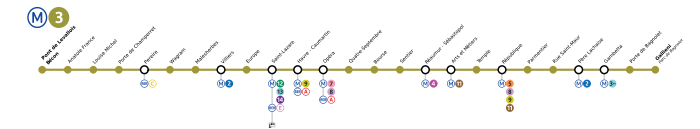
Map and stations
Renamed stations
- 15 October 1907: Rue St-Denis renamed Réaumur-Sébastopol.
- 1926: Caumartin renamed Havre-Caumartin
- 1 May 1946: Vallier renamed Louise Michel in honour of the leader of the "La CommuneParis CommuneThe Paris Commune was a government that briefly ruled Paris from March 18 to May 28, 1871. It existed before the split between anarchists and Marxists had taken place, and it is hailed by both groups as the first assumption of power by the working class during the Industrial Revolution...
". - September 1998: Saint-Maur is renamed Rue Saint-Maur in order to avoid confusion with the suburb of Saint-Maur-les-Fossées.
Facts
- Due to connections with other adjacent stations, it is possible to walk between three stations on the line without heading to the surface. This is done by starting at Saint-Lazare (Métro 3, 12, 13 and 14), then transferring to Hausmann Saint-Lazare station (RER E), from there going to Havre – Caumartin (Métro 3 and 9) then connecting to Auber (RER A) and finally walking from there to Opéra (Métro 3, 7 and 8). The journey can also be made the other way round (Opéra to Saint-Lazare)
Tourism
Line 3 passes near several places of interest :- St-Lazare railway stationGare Saint-LazareParis Saint-Lazare is one of the six large terminus train stations of Paris. It is the second busiest in Paris, behind the Gare du Nord, handling 274,000 passengers each day.-History:...
. - The Opera GarnierPalais GarnierThe Palais Garnier, , is an elegant 1,979-seat opera house, which was built from 1861 to 1875 for the Paris Opera. It was originally called the Salle des Capucines because of its location on the Boulevard des Capucines in the 9th arrondissement of Paris, but soon became known as the Palais Garnier...
. - The Bourse (Paris Stock Exchange).
- The area of the Sentier.
- Place de la République.
- Père Lachaise cemetery.