

Paranapanema River
Encyclopedia
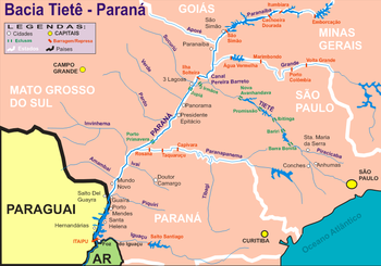
The Paranapanema River is one of the most important rivers of the interior of the Brazilian state of São Paulo
. The river forms the boundary between the states of São Paulo and Paraná
.
From source to its mouth the Paranapanema River has an elevation drop of 570 metres (1,870.1 ft). The river's length is about 929 kilometres (577.3 mi). It flows generally west, reaching the Paraná River
at an altitude of about 233 metres (764.4 ft).
The sources of the Paranapanema River are situated in the Serra Agudos Grandes, in southeastern São Paulo, approximately 100 kilometres (62.1 mi) from the Atlantic coast.
From the sources to the mouth of the Itararé River
, the Paranapaneba flows within the territory of São Paulo. Below the Itararé the Paranapanema forms the border between the states of Paraná and São Paulo.
The river is associated with a date according to State Law 10.488/99 (Antônio Salim Curiati
), sanctioned by Governor Mário Covas
, designated as August 27.
The Paranapanema is the least polluted river of the state of São Paulo.
is 61 cm/km, not considering the first 100 km, where the river descends from the Serra of Paranapiacaba, at an average gradient of 43 cm/km, a value relatively low for a stream with a length of 929 km.
The Paranapanema river may be divided into three principal stretches:
ing presenting a complete horizontal equilibrium, with an excess, only of the stretch close to the junction with the Paraná river
, where one may notice the existence of moving sand-banks and islands.
, with a length of 328 km, the river descends a total of 210 m. It is not possible to calculate an average gradient on this stretch, because due to the construction of various dams for the provisioning of hydroelectric power, the level will fall abruptly at those dams.
 The Upper Paranapanema reaches from the confluence of the Apiaí-Guaçu River to the river's sources in the Serra de Agudos Grandes, with a length of 180 km. The average gradient is quite high, 150 cm/km. It drains a series of streams that descend from the Serra of Paranapiacaba, the Upper Paranapanema is gaining size and consolidates to receive the Itapetininga River
and Apiaí-Guaçu river.
, down the chute of the Coroa do Frade, with a length of about 70 km, counting from the mouth into the Paraná river
. Navigation is fairly hazardous. Under normal conditions the minimum depth of this stretch may be estimated at about 1.5 metres (4.9 ft).
For the last 421 km downstream, the course between the mouth and the dam of Salto Grande, the average gradient is an about 29 cm/km.
The main natural obstacles that interrupt or make navigation dangerous are: a basalt bank, hidden rocks, reduced current velocity, too little depth, a straight canal in the middle of the river, an elevated current velocity, an undulating movement, a sinuous canal, sand banks, and stretches with high gradient.
The great reserves of water held in the Paranapanema's reservoirs have considerable influence on the regime of the river in its middle course. In the lower course the influence is reduced, with no effect on the natural conditions that completely impede navigation.
.
São Paulo (state)
São Paulo is a state in Brazil. It is the major industrial and economic powerhouse of the Brazilian economy. Named after Saint Paul, São Paulo has the largest population, industrial complex, and economic production in the country. It is the richest state in Brazil...
. The river forms the boundary between the states of São Paulo and Paraná
Paraná (state)
Paraná is one of the states of Brazil, located in the South of the country, bordered on the north by São Paulo state, on the east by the Atlantic Ocean, on the south by Santa Catarina state and the Misiones Province of Argentina, and on the west by Mato Grosso do Sul and the republic of Paraguay,...
.
From source to its mouth the Paranapanema River has an elevation drop of 570 metres (1,870.1 ft). The river's length is about 929 kilometres (577.3 mi). It flows generally west, reaching the Paraná River
Paraná River
The Paraná River is a river in south Central South America, running through Brazil, Paraguay and Argentina for some . It is second in length only to the Amazon River among South American rivers. The name Paraná is an abbreviation of the phrase "para rehe onáva", which comes from the Tupi language...
at an altitude of about 233 metres (764.4 ft).
The sources of the Paranapanema River are situated in the Serra Agudos Grandes, in southeastern São Paulo, approximately 100 kilometres (62.1 mi) from the Atlantic coast.
From the sources to the mouth of the Itararé River
Itararé River
The Itararé River is a river on the boundary between the Paraná and São Paulo states in southeastern Brazil.-References:*...
, the Paranapaneba flows within the territory of São Paulo. Below the Itararé the Paranapanema forms the border between the states of Paraná and São Paulo.
The river is associated with a date according to State Law 10.488/99 (Antônio Salim Curiati
Antonio Salim Curiati
Antônio Salim Curiati Antônio Salim Curiati Antônio Salim Curiati (Avaré, 13 February 1928 is a Brazilian medic, and politician. He was Mayor of São Paulo from 13 May 1982 to 14 March 1983.-Early life:...
), sanctioned by Governor Mário Covas
Mário Covas
Mário Covas Júnior was a Brazilian politician.Covas studied engineering at the Polytechnic School of the University of São Paulo. He entered politics in his native city of Santos, in the state of São Paulo....
, designated as August 27.
The Paranapanema is the least polluted river of the state of São Paulo.
Gradient
The average total gradient of the Paranapanema River, from its sources to its mouth in the Paraná riverParaná River
The Paraná River is a river in south Central South America, running through Brazil, Paraguay and Argentina for some . It is second in length only to the Amazon River among South American rivers. The name Paraná is an abbreviation of the phrase "para rehe onáva", which comes from the Tupi language...
is 61 cm/km, not considering the first 100 km, where the river descends from the Serra of Paranapiacaba, at an average gradient of 43 cm/km, a value relatively low for a stream with a length of 929 km.
The Paranapanema river may be divided into three principal stretches:
Lower Paranapanema
From its mouth at the Paraná River, to the Grande Falls, a length of 421 km, the average gradient is 29 cm/km. There are widths of more than 200 m, deeper and shallower stretches, widths that reach nearly 800 m. The radii of curvature are in the order of 1.000 m. The course is more or less meanderMeander
A meander in general is a bend in a sinuous watercourse. A meander is formed when the moving water in a stream erodes the outer banks and widens its valley. A stream of any volume may assume a meandering course, alternately eroding sediments from the outside of a bend and depositing them on the...
ing presenting a complete horizontal equilibrium, with an excess, only of the stretch close to the junction with the Paraná river
Paraná River
The Paraná River is a river in south Central South America, running through Brazil, Paraguay and Argentina for some . It is second in length only to the Amazon River among South American rivers. The name Paraná is an abbreviation of the phrase "para rehe onáva", which comes from the Tupi language...
, where one may notice the existence of moving sand-banks and islands.
Middle Paranapanema
From the Grande Falls up to the confluence with the Apiaí-Guaçu RiverApiai-Guaçu River
The Apiai-Guaçu River is a river of São Paulo state in southeastern Brazil.-References:*...
, with a length of 328 km, the river descends a total of 210 m. It is not possible to calculate an average gradient on this stretch, because due to the construction of various dams for the provisioning of hydroelectric power, the level will fall abruptly at those dams.
Upper Paranapanema
Itapetininga River
The Itapetininga River is a river of São Paulo state in southeastern Brazil. It is a tributary of the Paranapanema River.-See also:* List of rivers of São Paulo...
and Apiaí-Guaçu river.
Navigation
Navigation of the Paranapanema River is practical along the lower course up to the port of Euclides da CunhaEuclides da Cunha
Euclides da Cunha was a Brazilian writer, sociologist and engineer. His most important work is Os Sertões , a non-fictional account of the military expeditions promoted by the Brazilian government against the rebellious village of Canudos, known as the War of Canudos...
, down the chute of the Coroa do Frade, with a length of about 70 km, counting from the mouth into the Paraná river
Paraná River
The Paraná River is a river in south Central South America, running through Brazil, Paraguay and Argentina for some . It is second in length only to the Amazon River among South American rivers. The name Paraná is an abbreviation of the phrase "para rehe onáva", which comes from the Tupi language...
. Navigation is fairly hazardous. Under normal conditions the minimum depth of this stretch may be estimated at about 1.5 metres (4.9 ft).
For the last 421 km downstream, the course between the mouth and the dam of Salto Grande, the average gradient is an about 29 cm/km.
The main natural obstacles that interrupt or make navigation dangerous are: a basalt bank, hidden rocks, reduced current velocity, too little depth, a straight canal in the middle of the river, an elevated current velocity, an undulating movement, a sinuous canal, sand banks, and stretches with high gradient.
The great reserves of water held in the Paranapanema's reservoirs have considerable influence on the regime of the river in its middle course. In the lower course the influence is reduced, with no effect on the natural conditions that completely impede navigation.
Dams and reservoirs
The Paranapanema River has in total eight dams and their respective reservoirs. The following table traces a list going in the direction of the Paraná RiverParaná River
The Paraná River is a river in south Central South America, running through Brazil, Paraguay and Argentina for some . It is second in length only to the Amazon River among South American rivers. The name Paraná is an abbreviation of the phrase "para rehe onáva", which comes from the Tupi language...
.
| Dam | Reservoir | power generation | Área of the reservoir |
|---|---|---|---|