
Palo Alto Battlefield National Historic Site
Encyclopedia
Palo Alto Battlefield National Historical Park near Brownsville, Texas
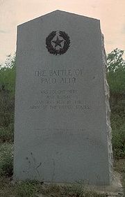
preserves the grounds of the May 8, 1846, Battle of Palo Alto
. It was the first major conflict in a border dispute that soon precipitated the Mexican-American War. The United States Army
victory here made the invasion of Mexico possible. The historic site portrays the battle and the war, and its causes and consequences, from the perspectives of both the United States
and Mexico
.
The National Park Service
has acquired a little more than a third of the authorized land for the park, including the 300 acres (1.2 km²) southern core battlefield tract, which served as the location for Mexican forces during the Battle of Palo Alto. Private landowners still control some 2000 acres (8.1 km²) of the battlefield. Honey Mesquite
(Prosopis glandulosa), although a native plant, is present in an unusually high concentration, altering the cultural landscape and threatening the natural and cultural resources at the park.
 The park's visitor center features exhibits about the battle and the Mexican-American War, as well as a 15 minute video titled "War on the Rio Grande". A 1/2 mile trail leads to an overlook of the battlefield and includes interpretive panels.
on December 19, 1960. It became Palo Alto Battlefield National Historic Site on November 10, 1978, with a boundary change authorized on June 23, 1992. On March 30, 2009 the site was redesignated a National Historical Park
, and the park was expanded to include the Resaca de la Palma Battlefield
, which is a separate 34 acres inside the Brownsville city limits.
Brownsville, Texas
Brownsville is a city in the southernmost tip of the state of Texas, in the United States. It is located on the northern bank of the Rio Grande, directly north and across the border from Matamoros, Tamaulipas, Mexico. Brownsville is the 16th largest city in the state of Texas with a population of...
preserves the grounds of the May 8, 1846, Battle of Palo Alto
Battle of Palo Alto
The Battle of Palo Alto was the first major battle of the Mexican-American War and was fought on May 8, 1846, on disputed ground five miles from the modern-day city of Brownsville, Texas...
. It was the first major conflict in a border dispute that soon precipitated the Mexican-American War. The United States Army
United States Army
The United States Army is the main branch of the United States Armed Forces responsible for land-based military operations. It is the largest and oldest established branch of the U.S. military, and is one of seven U.S. uniformed services...
victory here made the invasion of Mexico possible. The historic site portrays the battle and the war, and its causes and consequences, from the perspectives of both the United States
United States
The United States of America is a federal constitutional republic comprising fifty states and a federal district...
and Mexico
Mexico
The United Mexican States , commonly known as Mexico , is a federal constitutional republic in North America. It is bordered on the north by the United States; on the south and west by the Pacific Ocean; on the southeast by Guatemala, Belize, and the Caribbean Sea; and on the east by the Gulf of...
.
The National Park Service
National Park Service
The National Park Service is the U.S. federal agency that manages all national parks, many national monuments, and other conservation and historical properties with various title designations...
has acquired a little more than a third of the authorized land for the park, including the 300 acres (1.2 km²) southern core battlefield tract, which served as the location for Mexican forces during the Battle of Palo Alto. Private landowners still control some 2000 acres (8.1 km²) of the battlefield. Honey Mesquite
Honey Mesquite
Prosopis glandulosa, commonly known as honey mesquite, is a species of small to medium-sized flowering tree in the legume family, Fabaceae. It is native to the Southwestern United States and Mexico, growing as far north as southern Kansas and as far east as the eastern fifth of Texas, where...
(Prosopis glandulosa), although a native plant, is present in an unusually high concentration, altering the cultural landscape and threatening the natural and cultural resources at the park.
Administrative history
Palo Alto Battlefield was designated a National Historic LandmarkNational Historic Landmark
A National Historic Landmark is a building, site, structure, object, or district, that is officially recognized by the United States government for its historical significance...
on December 19, 1960. It became Palo Alto Battlefield National Historic Site on November 10, 1978, with a boundary change authorized on June 23, 1992. On March 30, 2009 the site was redesignated a National Historical Park
National Historical Park
National Historic Sites are protected areas of national historic significance in the United States. A National Historic Site usually contains a single historical feature directly associated with its subject...
, and the park was expanded to include the Resaca de la Palma Battlefield
Resaca De La Palma Battlefield
The Resaca de la Palma Battlefield is the site in Brownsville, Texas, where American forces under General Zachary Taylor engaged Mexican forces under General Mariano Arista on May 9, 1846 in the Battle of Resaca de la Palma. In the early stages of the Mexican-American War, and immediately...
, which is a separate 34 acres inside the Brownsville city limits.
External links
- Official NPS website: Palo Alto Battlefield National Historical Park
- Palo Alto Battlefield NHL information
- National Park Lover Page: Palo Alto Battlefield National Historical Park