

Ournie, New South Wales
Encyclopedia
Ournie is a rural community in the far south east part of the Riverina
and situated about 15 kilometres north west from Welaregang
and 20 kilometres south from Munderoo
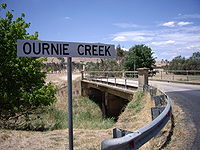
. Ournie is situated on the banks of the Ournie Creek which flows into the Murray River
and the area is only about 4 kilometres from the border of Victoria.
Ournie Post Office opened on 1 July 1872, closed in 1875, reopened in 1904 and closed again in 1968.
Riverina
The Riverina is an agricultural region of south-western New South Wales , Australia. The Riverina is distinguished from other Australian regions by the combination of flat plains, warm to hot climate and an ample supply of water for irrigation. This combination has allowed the Riverina to develop...
and situated about 15 kilometres north west from Welaregang
Welaregang, New South Wales
Welaregang is a rural community in the far south east part of the Riverina and situated about 11 kilometres south west from Tooma and 15 kilometres south east from Ournie. At the 2006 census, Welaregang had a population of 162....
and 20 kilometres south from Munderoo
Munderoo, New South Wales
Munderoo is a rural community in the south east part of the Riverina. It is situated about 11 kilometres west from Mannus and 16 kilometres north from Ournie...
. Ournie is situated on the banks of the Ournie Creek which flows into the Murray River
Murray River
The Murray River is Australia's longest river. At in length, the Murray rises in the Australian Alps, draining the western side of Australia's highest mountains and, for most of its length, meanders across Australia's inland plains, forming the border between New South Wales and Victoria as it...
and the area is only about 4 kilometres from the border of Victoria.
Ournie Post Office opened on 1 July 1872, closed in 1875, reopened in 1904 and closed again in 1968.