
Otaki, Nagano
Encyclopedia
is a village
located in Kiso District, Nagano
, Japan
.
 . This is a pattern that has developed over time starting in the 16th century when a large majority of forestland in the Kiso Valley was claimed by Toyotomi Hideyoshi
, in part to build his castle at Inuyama.
Demographically, Ōtaki is undergoing drastic changes. The population structure of Ōtaki is similar to that found in rural areas across Japan; a rising elderly population coupled with a decline in overall population. Ōtaki’s population currently stands at 995, down from 1,768 in 1980. During this same period the rate of elderly residents has risen to 32.4%. Though tourism remains the primary industry in Ōtaki, tourist numbers (including skiers and worshipers) have declined in recent years. After tourism, manufacturing jobs are the most prevalent, followed finally by agriculture. On the ground, this pattern takes the form of elderly residents engaging in agricultural work, while younger family members (if any remain in the village) work outside of the home.
Ōtaki is struggling economically, due in large part to public debt accrued through the building and management of Ontake 2240 ski hill. For 2008 roughly 3/4 of Ōtaki’s annual budget is slated for administrative and financial operations, with almost a quarter of this being used to pay back public debt. This leaves only a fraction of funds for use in providing basic services such as sanitation, health, and education. Major cuts have been made to the salaries of village employees and to money spent social, cultural, and educational activities.
Villages of Japan
A is a local administrative unit in Japan.It is a local public body along with , , and . Geographically, a village's extent is contained within a prefecture....
located in Kiso District, Nagano
Kiso District, Nagano
is a district located in Nagano Prefecture, Japan.As of November 1, 2005, the district has an estimated population of 34,759. The total area is 1,546.26 km².Historically, the district was once known as Nishichikuma District until May 1, 1968....
, Japan
Japan
Japan is an island nation in East Asia. Located in the Pacific Ocean, it lies to the east of the Sea of Japan, China, North Korea, South Korea and Russia, stretching from the Sea of Okhotsk in the north to the East China Sea and Taiwan in the south...
.
History
- 1504: There remains a record of Ōtaki being established at this time as part of the Chikuma Region of ShinanoShinano Provinceor is an old province of Japan that is now present day Nagano Prefecture.Shinano bordered on Echigo, Etchū, Hida, Kai, Kōzuke, Mikawa, Mino, Musashi, Suruga, and Tōtōmi Provinces...
- 1868: Takigoshi Village (滝越村)is incorporated as part of Ōtaki.
- 1871: With the abolition of feudal domains and the establishment of prefectures, Ōtaki becomes part of Nagoya Prefecture, but is amalgamated, along with other prefectures, in November of that year to become part of Chikuma Prefecture.
- 1876: The section of Chikuma Prefecture where Ōtaki is located becomes part of Nagano Prefecture, thus becoming Ōtaki Village, Chikuma District, Nagano Prefecture.
- -1917: Construction begins on the Ōtaki forest railroad (王滝 森林鉄道)
- June 30, 1975: The Ōtaki forest railroad is decommissioned with the last run of the "Yamabato" train.
- May 1, 1968: The Chikuma District has its name changed to its current "Kiso District".
- 1979: Mt. Ontake erupts.
- September 14, 1984: Nagano Western Earthquake causes a section of Mt. Ontake to crumble and flow into the Ōtaki Valley. 29 people are reported dead or missing and 87 homes are destroyed.
Present-day Ōtaki
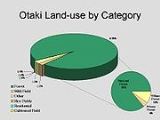
At present Ōtaki's land area is 310.86 km2 of which 295.85 km2 (95%) is forestland; 86% of which is designated national forestToyotomi Hideyoshi
was a daimyo warrior, general and politician of the Sengoku period. He unified the political factions of Japan. He succeeded his former liege lord, Oda Nobunaga, and brought an end to the Sengoku period. The period of his rule is often called the Momoyama period, named after Hideyoshi's castle...
, in part to build his castle at Inuyama.
Demographically, Ōtaki is undergoing drastic changes. The population structure of Ōtaki is similar to that found in rural areas across Japan; a rising elderly population coupled with a decline in overall population. Ōtaki’s population currently stands at 995, down from 1,768 in 1980. During this same period the rate of elderly residents has risen to 32.4%. Though tourism remains the primary industry in Ōtaki, tourist numbers (including skiers and worshipers) have declined in recent years. After tourism, manufacturing jobs are the most prevalent, followed finally by agriculture. On the ground, this pattern takes the form of elderly residents engaging in agricultural work, while younger family members (if any remain in the village) work outside of the home.
Ōtaki is struggling economically, due in large part to public debt accrued through the building and management of Ontake 2240 ski hill. For 2008 roughly 3/4 of Ōtaki’s annual budget is slated for administrative and financial operations, with almost a quarter of this being used to pay back public debt. This leaves only a fraction of funds for use in providing basic services such as sanitation, health, and education. Major cuts have been made to the salaries of village employees and to money spent social, cultural, and educational activities.
External links
- Ōtaki official website
- In The Pines blog about Ōtaki