
Ospel
Encyclopedia
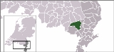
Ospel is a village in The Netherlands. It is located in Limburg
near Weert
, lying between Nederweert
and Meijel
, close to National Park De Groote Peel
. Ospel's population on 1 January 2006 was 4,054. Ospel has been settled in 1864 as a center for Bog
harvesting.
Limburg (Netherlands)
Limburg is the southernmost of the twelve provinces of the Netherlands. It is located in the southeastern part of the country and bordered by the province of Gelderland to the north, Germany to the east, Belgium to the south and part of the west, andthe Dutch province of North Brabant partly to...
near Weert
Weert
Weert is a municipality and city in the southeastern Netherlands. As of 2010, Weert had a population of 48,405. It lies on the Eindhoven–Maastricht railway line, and is also astride the Zuid-Willemsvaart canal.- Population centres :* Altweerterheide...
, lying between Nederweert
Nederweert
Nederweert is a municipality and a town in southeastern Netherlands with 16.561 inhabitants as of November 1, 2006 and has a surface area of 101,78 km² ....
and Meijel
Meijel
-External links:**...
, close to National Park De Groote Peel
National Park De Groote Peel
thumb|right|A lonesome [[birch]] tree in the [[heath |heath]] next to a trackDe Groote Peel is a National Park in the Peel, a region in the Southeast of the Netherlands on the border between the provinces of Limburg and North Brabant...
. Ospel's population on 1 January 2006 was 4,054. Ospel has been settled in 1864 as a center for Bog
Bog
A bog, quagmire or mire is a wetland that accumulates acidic peat, a deposit of dead plant material—often mosses or, in Arctic climates, lichens....
harvesting.
Schooling
Ospel has a primary school. Ospel does not have a high school. Teenagers are required to attend schools in nearby cities, such as Weert, 8.5 kilometres (5.3 mi) from Ospel.Nearby Cities
- Eindhoven is the closest city with more than 100,000 citizens (207,005, Google EarthGoogle EarthGoogle Earth is a virtual globe, map and geographical information program that was originally called EarthViewer 3D, and was created by Keyhole, Inc, a Central Intelligence Agency funded company acquired by Google in 2004 . It maps the Earth by the superimposition of images obtained from satellite...
, January 2008) at 26.3 kilometres (16.3 mi). - RoermondRoermondRoermond is a city, a municipality, and a diocese in the southeastern part of the Netherlands.The city of Roermond is a historically important town, on the lower Roer at the east bank of the Meuse river. It received city rights in 1231...
is the closest city with more than 50,000 citizens (82,402, Google Earth, January 2008) at 22.8 kilometres (14.2 mi). - WeertWeertWeert is a municipality and city in the southeastern Netherlands. As of 2010, Weert had a population of 48,405. It lies on the Eindhoven–Maastricht railway line, and is also astride the Zuid-Willemsvaart canal.- Population centres :* Altweerterheide...
is the closest city with more than 30,000 citizens (47,699, Google Earth, January 2008) at 7.2 kilometres (4.5 mi).