Orono, Maine
Encyclopedia
Orono is a town
in Penobscot County
, Maine
, United States
. It was first settled in 1774 and named in honor of Chief Joseph Orono
of the Penobscot Nation. It is home to The University of Maine
. The population was 10,362 at the 2010 census.
, the town has a total area of 19.8 square miles (51.2 km²), of which, 18.2 square miles (47.2 km²) of it is land and 1.6 square miles (4.1 km²) of it is water. The total area is 7.94% water. The town is divided by the Stillwater River
, a branch of the Penobscot River
, with part occupying part of Marsh Island, which is surrounded by the Penobscot and the Stillwater, and the other part on the mainland.

As of the census
of 2000, the town had a population of 9,112 people, 2,691 households, and 1,291 families residing in the town. The population density
is 500.3 people per square mile (193.2/km²). There are 2,899 housing units at an average density of 159.2 per square mile (61.5/km²). The racial makeup of the town was 93.54% White, 1.38% Black or African American, 0.95% Native American, 2.39% Asian, 0.07% Pacific Islander, 0.52% from other races, and 1.15% from two or more races. Hispanic or Latino of any race were 1.21% of the population.
There were 2,691 households out of which 21.7% had children under the age of 18 living with them, 36.6% were married couples
living together, 8.5% had a female householder with no husband present, and 52.0% were non-families. 31.5% of all households were made up of individuals and 10.0% had someone living alone who is 65 years of age or older. The average household size was 2.23 and the average family size was 2.81.
In the town the population was spread out with 11.9% under the age of 18, 47.9% from 18 to 24, 17.1% from 25 to 44, 13.8% from 45 to 64, and 9.3% who were 65 years of age or older. The median age was 22 years. For every 100 females there were 102.5 males. For every 100 females age 18 and over, there were 102.1 males.
The median income for a household in the town was $30,619, and the median income for a family was $52,714. Males had a median income of $35,923 versus $24,943 for females. The per capita income
for the town was $14,813. About 10.3% of families and 25.0% of the population were below the poverty line, including 21.8% of those under the age of 18 and 6.2% of those 65 and older are living below the poverty line.

New England town
The New England town is the basic unit of local government in each of the six New England states. Without a direct counterpart in most other U.S. states, New England towns are conceptually similar to civil townships in other states, but are incorporated, possessing powers like cities in other...
in Penobscot County
Penobscot County, Maine
Penobscot County is a county located in the U.S. state of Maine. For U.S. Census statistical purposes, it is part of the Bangor, Maine, New England County Metropolitan Area . As of 2010, the population was 153,923...
, Maine
Maine
Maine is a state in the New England region of the northeastern United States, bordered by the Atlantic Ocean to the east and south, New Hampshire to the west, and the Canadian provinces of Quebec to the northwest and New Brunswick to the northeast. Maine is both the northernmost and easternmost...
, United States
United States
The United States of America is a federal constitutional republic comprising fifty states and a federal district...
. It was first settled in 1774 and named in honor of Chief Joseph Orono
Joseph Orono
Joseph Orono was a Penobscot Indian chief or sachem who lived on the Penobscot River in present-day Maine. The town of Orono, Maine, which contains the University of Maine, is named for him....
of the Penobscot Nation. It is home to The University of Maine
University of Maine
The University of Maine is a public research university located in Orono, Maine, United States. The university was established in 1865 as a land grant college and is referred to as the flagship university of the University of Maine System...
. The population was 10,362 at the 2010 census.
Geography
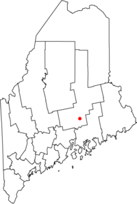
Orono is located at about 44.8998 degrees latitude, -68.67444 degrees longitude. According to the United States Census BureauUnited States Census Bureau
The United States Census Bureau is the government agency that is responsible for the United States Census. It also gathers other national demographic and economic data...
, the town has a total area of 19.8 square miles (51.2 km²), of which, 18.2 square miles (47.2 km²) of it is land and 1.6 square miles (4.1 km²) of it is water. The total area is 7.94% water. The town is divided by the Stillwater River
Stillwater River (Maine)
The Stillwater River is an side channel of the Penobscot River in Maine. From its source in Old Town, the Stillwater runs northwest along the northeast side of Orson Island, the site of the Penobscot Indian Reservation. It then runs south along the west sides of Orson and Marsh islands, over...
, a branch of the Penobscot River
Penobscot River
The Penobscot River is a river in the U.S. state of Maine. Including the river's West Branch and South Branch increases the Penobscot's length to , making it the second longest river system in Maine and the longest entirely in the state. Its drainage basin contains .It arises from four branches...
, with part occupying part of Marsh Island, which is surrounded by the Penobscot and the Stillwater, and the other part on the mainland.
Demographics

As of the census
Census
A census is the procedure of systematically acquiring and recording information about the members of a given population. It is a regularly occurring and official count of a particular population. The term is used mostly in connection with national population and housing censuses; other common...
of 2000, the town had a population of 9,112 people, 2,691 households, and 1,291 families residing in the town. The population density
Population density
Population density is a measurement of population per unit area or unit volume. It is frequently applied to living organisms, and particularly to humans...
is 500.3 people per square mile (193.2/km²). There are 2,899 housing units at an average density of 159.2 per square mile (61.5/km²). The racial makeup of the town was 93.54% White, 1.38% Black or African American, 0.95% Native American, 2.39% Asian, 0.07% Pacific Islander, 0.52% from other races, and 1.15% from two or more races. Hispanic or Latino of any race were 1.21% of the population.
There were 2,691 households out of which 21.7% had children under the age of 18 living with them, 36.6% were married couples
Marriage
Marriage is a social union or legal contract between people that creates kinship. It is an institution in which interpersonal relationships, usually intimate and sexual, are acknowledged in a variety of ways, depending on the culture or subculture in which it is found...
living together, 8.5% had a female householder with no husband present, and 52.0% were non-families. 31.5% of all households were made up of individuals and 10.0% had someone living alone who is 65 years of age or older. The average household size was 2.23 and the average family size was 2.81.
In the town the population was spread out with 11.9% under the age of 18, 47.9% from 18 to 24, 17.1% from 25 to 44, 13.8% from 45 to 64, and 9.3% who were 65 years of age or older. The median age was 22 years. For every 100 females there were 102.5 males. For every 100 females age 18 and over, there were 102.1 males.
The median income for a household in the town was $30,619, and the median income for a family was $52,714. Males had a median income of $35,923 versus $24,943 for females. The per capita income
Per capita income
Per capita income or income per person is a measure of mean income within an economic aggregate, such as a country or city. It is calculated by taking a measure of all sources of income in the aggregate and dividing it by the total population...
for the town was $14,813. About 10.3% of families and 25.0% of the population were below the poverty line, including 21.8% of those under the age of 18 and 6.2% of those 65 and older are living below the poverty line.
Notable people

- Wallace Rider Farrington, territorial governor of Hawaii.
- Constance HuntingConstance HuntingConstance Hunting , the poet and publisher, was widely known in the Northeastern United States, particularly in her home state of Rhode Island, her adopted state of Indiana, and later in Maine where she taught English literature and creative writing at the University of Maine at Orono until her...
, poet, publisher. - Jonathan NorcrossJonathan NorcrossJonathan Norcross , fourth Mayor of Atlanta, GA. Dubbed the "Father of Atlanta" and "hard fighter of everything." - Henry W. Grady - Personal life :...
, inventor, 4th Mayor of Atlanta. - Elizabeth SchneiderElizabeth SchneiderRichard Rosen is an American politician. Schneider is a Democratic State Senator from Maine's 32nd District, representing part of Penobscot County, including the population centers of Orono and Lincoln...
, state senator - Katee StearnsKatee StearnsKatee June Stearns is a beauty queen from Orono, Maine, who has competed in the Miss USA pageant.Stearns was crowned Miss Maine USA 2006 on Thanksgiving Weekend, 2005, at the The Sheraton Hotel in South Portland, Maine...
, Miss Maine USA (2006). - Israel Washburn, Jr.Israel Washburn, Jr.Israel Washburn, Jr. was a United States political figure. Originally a member of the Whig Party, he later became a founding member of the Republican Party....
, congressman, a founder of the Republican PartyRepublican Party (United States)The Republican Party is one of the two major contemporary political parties in the United States, along with the Democratic Party. Founded by anti-slavery expansion activists in 1854, it is often called the GOP . The party's platform generally reflects American conservatism in the U.S...
, 29th Governor of Maine. - Dorothy Clarke WilsonDorothy Clarke WilsonDorothy Clarke Wilson was an American author and playwright.Dorothy Clarke was born in Gardiner, Maine in 1904. She attended Bates College and graduated Phi Beta Kappa in 1925 and married classmate, Elwin L. Wilson...
, novelist, playwright.
Points of interest
- University of MaineUniversity of MaineThe University of Maine is a public research university located in Orono, Maine, United States. The university was established in 1865 as a land grant college and is referred to as the flagship university of the University of Maine System...
- Fay Hyland Botanical PlantationFay Hyland Botanical PlantationThe Fay Hyland Botanical Plantation , 10 acres , is an arboretum and botanical garden located along the Stillwater River on the University of Maine campus in Orono, Maine, USA...
- Lyle E. Littlefield Ornamentals Trial Garden
- Old Fire Engine HouseOld Fire Engine HouseOld Fire Engine House, is located in Orono, Maine. The fire station was built in 1892 and was added to the National Register of Historic Places on September 12, 1985....
- Pat's PizzaPat's PizzaPat's Pizza is a chain of restaurants in Maine. The chain was started in 1931 when Carl D. "Pat" Farnsworth bought the ice cream store in Orono, Maine in which he had worked as a high-schooler. In 1953, he added pizza to the menu, and it was such a hit that he changed Farnsworth's Cafe into a pizza...

