
Oregon Route 200
Encyclopedia
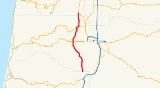
Oregon Route 200 is an Oregon
state highway
running from OR 99W at Monroe
to the Lane
-Douglas County
line near Anlauf
. OR 200 is composed of most of the Territorial Highway No. 200 (see Oregon highways and routes). It is 40.64 miles (65.4 km) long, in two segments broken by a section of OR 36 and runs north–south.
OR 200 was established in 2002 as part of Oregon's project to assign route numbers to highways that previously were not assigned, and, as of June 2009, was unsigned.
to Veneta
. At Veneta, OR 200 crosses OR 126 and continues south through Crow
and Lorane
to the Lane-Douglas County line, where it ends. An old section of the Territorial Highway continues south as a Douglas County road to Anlauf, where it ends at an intersection with OR 99.
OR 200 was assigned to the remaining part of the Territorial Highway, except that section which is part of OR 36, in 2002.
OR 200 begins at a negative milepost. The Department of Transportation
placed the zero milepost at a highway connection point slightly displaced from the beginning of the route.
Oregon
Oregon is a state in the Pacific Northwest region of the United States. It is located on the Pacific coast, with Washington to the north, California to the south, Nevada on the southeast and Idaho to the east. The Columbia and Snake rivers delineate much of Oregon's northern and eastern...
state highway
State highway
State highway, state road or state route can refer to one of three related concepts, two of them related to a state or provincial government in a country that is divided into states or provinces :#A...
running from OR 99W at Monroe
Monroe, Oregon
Monroe is a city in Benton County, Oregon, United States. The population was 607 at the 2000 census. It is part of the "Corvallis, Oregon Metropolitan Statistical Area"...
to the Lane
Lane County, Oregon
-National protected areas:*Oregon Islands National Wildlife Refuge *Siuslaw National Forest *Umpqua National Forest *Willamette National Forest -Government:...
-Douglas County
Douglas County, Oregon
-National protected areas:* Crater Lake National Park * Rogue River-Siskiyou National Forest * Siuslaw National Forest * Umpqua National Forest * Willamette National Forest -Adjacent counties:* Lane County, Oregon -...
line near Anlauf
Anlauf, Oregon
Anlauf is an unincorporated community in Douglas County, Oregon, United States. Anlauf is located along Interstate 5 north of Yoncalla....
. OR 200 is composed of most of the Territorial Highway No. 200 (see Oregon highways and routes). It is 40.64 miles (65.4 km) long, in two segments broken by a section of OR 36 and runs north–south.
OR 200 was established in 2002 as part of Oregon's project to assign route numbers to highways that previously were not assigned, and, as of June 2009, was unsigned.
Route description
OR 200 begins at an intersection with OR 99W in Monroe. It heads south through Bear Creek to an intersection with OR 36, at which point the Territorial Highway overlaps the Mapleton-Junction City Highway No. 229. The concurrency continues west for 1.48 miles (2.4 km) as OR 36, at which point OR 200 heads south through ElmiraElmira, Oregon
Elmira is an unincorporated community in Lane County, Oregon, United States. It is located west of Eugene and north of Veneta and Oregon Route 126, near the Long Tom River and Fern Ridge Reservoir....
to Veneta
Veneta, Oregon
Veneta is a city in Lane County, Oregon, United States. As of the 2010 census, the city population was 4,561.-History:Veneta was established in 1912 by Edmund Eugene Hunter, who named the settlement after his five-year-old daughter. Veneta post office was established in 1914. Veneta Orilla Hunter...
. At Veneta, OR 200 crosses OR 126 and continues south through Crow
Crow, Oregon
Crow is an unincorporated community in Lane County, Oregon, United States.-History:According to Oregon Geographic Names, a post office was established in 1874 and named after community founders James Andrew Jackson Crow and Helen Fisk Crow, pioneers who came to Oregon by wagon train...
and Lorane
Lorane, Oregon
Lorane is an unincorporated community in Lane County, Oregon, United States. It is located on Territorial Road about 20 miles southwest of Eugene; it is 13 miles northwest of Cottage Grove. The community is near the headwaters of the North Fork Siuslaw River in a valley in the foothills of the...
to the Lane-Douglas County line, where it ends. An old section of the Territorial Highway continues south as a Douglas County road to Anlauf, where it ends at an intersection with OR 99.
History
The Territorial Highway is one of Oregon's oldest roads. It can be traced to at least 1851, and by 1947 was referred to in a judicial opinion as the "Old Territorial Highway".OR 200 was assigned to the remaining part of the Territorial Highway, except that section which is part of OR 36, in 2002.
Major intersections
| Milepost | City | Intersection |
|---|---|---|
| -0.06 | Monroe Monroe, Oregon Monroe is a city in Benton County, Oregon, United States. The population was 607 at the 2000 census. It is part of the "Corvallis, Oregon Metropolitan Statistical Area"... |
OR 99W |
| 8.62 | Near Bear Creek | OR 36 (End North section) |
| 10.10 | Near Franklin Franklin, Oregon Franklin is an unincorporated community in Lane County, Oregon, United States. It is located near Veneta, and is approximately northwest of Eugene.-References:... |
OR 36 (Begin South section) |
| 19.49 | Veneta Veneta, Oregon Veneta is a city in Lane County, Oregon, United States. As of the 2010 census, the city population was 4,561.-History:Veneta was established in 1912 by Edmund Eugene Hunter, who named the settlement after his five-year-old daughter. Veneta post office was established in 1914. Veneta Orilla Hunter... |
OR 126 |
| 42.08 | Near Anlauf Anlauf, Oregon Anlauf is an unincorporated community in Douglas County, Oregon, United States. Anlauf is located along Interstate 5 north of Yoncalla.... |
End Route |
OR 200 begins at a negative milepost. The Department of Transportation
Oregon Department of Transportation
The Oregon Department of Transportation is a department of the state government of the U.S. state of Oregon responsible for systems of transportation. It was first established in 1969. It had been preceded by the Oregon State Highway Department which, along with the Oregon State Highway...
placed the zero milepost at a highway connection point slightly displaced from the beginning of the route.
Related routes
- OR 99W
- OR 36
- OR 126
- OR 99