

Old Kilcullen
Encyclopedia
Old Kilcullen, formerly Kilcullen (Cill Chuilinn, "the Church of the Holly" in Irish
), is a townland
in County Kildare
, Ireland
, which includes a noted religious archaeological site within its boundary. It was formerly the site of a walled town, and before that of an ecclesiastical settlement dating from the 5th century. The original settlement gave its name to the substantial surrounding Civil Parish
and barony.
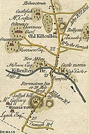
The urban centre of the area moved about 2 km west and slightly north to Kilcullen Bridge
on the River Liffey
, often now simply known as Kilcullen, over the centuries following the construction of a bridge there in 1319. Old Kilcullen is also under 5 km from Newbridge
and around 13 km from Naas
.
Old Kilcullen is the site of a round tower
and a decorated High Cross, and another, much older, historic site, Dun Ailinne
, is on the next hill to the west, Knockaulin.
At ground level today, the site appears to be confined to a churchyard with surviving stone features at the top of a gently sloping hill, but aerial and ground surveys have shown a far greater extent to the former settlement, including embankments on the slopes of the hill.
The site has no immediate public transport access but Kilcullen Bridge is served by two long-distance bus services, operated by Bus Éireann Teo. and JJ Kavanagh Ltd. Old Kilcullen is under 5 km from Newbridge and around 13 km from Naas.
The settlement was assigned a bishop, (St.) Iserninus
or Isernine, together with (St.) (Eoghan) MacTail or Mactalius, who later took sole responsibility. Whether these two were contemporaries is uncertain, as MacTail's date of death is usually given as June 11 548, and on the other hand, one source mentions only Mac Tail as founding bishop and one gives his death as occurring in 549
Old Kilcullen was raided by Vikings, landing at the location of the modern town, at least twice, in 936 and 944. In the former raid, it is reported that a thousand prisoners were taken, which suggests that the then population was very substantial. Other mentions in the Annals include reference to the deaths of key church figures, including Bishops and Abbots (sometimes the one person).
The town reached its peak in early Anglo-Norman times, as a walled town with seven gates and seven, or perhaps eight, roads, and regular markets. There was also some form of castle, which was by the time of Henry VIII held by the (Fitz-)Eustace family, who held for a time the title Baron of Kilcullen.
 The new town officially known and mapped as Kilcullen Bridge began to develop after 1319 when a bridge across the River Liffey was constructed at that place by a canon, Maurice Jakis (or Jacquis or Jakes), of Kildare Cathedral. It took over, over succeeding centuries, from the old centre, though until the late 19th century, Old Kilcullen townland had a greater population than Kilcullen Bridge. Originally, as shown on maps even as late as the late 18th century, the new settlement was wholly on the eastern bank of the Liffey.
, the first phase of which was won by the rebels, before they were driven out, and back to Knockaulin (Dun Ailinne
) by General Dundas. During the battle, the round tower was damaged, with, for example, the four windows mentioned in an account of 1782 being reduced to one. It was subsequently stabilised in its current form.
, until some time in the 19th century (after 1836), and revenue from this went to support two canons of Christchurch Cathedral, Dublin.
Activity was also lost as the main road from Dublin to Carlow (via Athy) diverted away from the hill.
The round tower was taken under State care in the late 19th century.
, the base of another large cross, and many graves. However, further traces of structures can be seen in aerial photography.
In addition to the historic area, the townland
of Old Kilcullen includes homes, farms, a public house, and a Kildare County Council
reservoir.
. One window, of at least four large windows seen in earlier illustrations and mentioned in descriptions, remains. The round-headed doorway, which is about 1.7m high at maximum, is about 2m above ground level. Beside the door is a plaque declaring the tower's protected status.
The "decorated high cross" has four illustrated faces, with a range of panels. It did not survive intact - it is known that it was leaning by 1862, and later lay on the ground for some years, and when it was remounted in the late 19th century, parts of at least one panel were lost, and parts of the panel which had been facing upwards had been badly eroded.
The "plain high cross" may have had the beginnings of decoration, but has no finished ornamentation.
Irish language
Irish , also known as Irish Gaelic, is a Goidelic language of the Indo-European language family, originating in Ireland and historically spoken by the Irish people. Irish is now spoken as a first language by a minority of Irish people, as well as being a second language of a larger proportion of...
), is a townland
Townland
A townland or bally is a small geographical division of land used in Ireland. The townland system is of Gaelic origin—most townlands are believed to pre-date the Norman invasion and most have names derived from the Irish language...
in County Kildare
County Kildare
County Kildare is a county in Ireland. It is part of the Mid-East Region and is also located in the province of Leinster. It is named after the town of Kildare. Kildare County Council is the local authority for the county...
, Ireland
Republic of Ireland
Ireland , described as the Republic of Ireland , is a sovereign state in Europe occupying approximately five-sixths of the island of the same name. Its capital is Dublin. Ireland, which had a population of 4.58 million in 2011, is a constitutional republic governed as a parliamentary democracy,...
, which includes a noted religious archaeological site within its boundary. It was formerly the site of a walled town, and before that of an ecclesiastical settlement dating from the 5th century. The original settlement gave its name to the substantial surrounding Civil Parish
Civil parish
In England, a civil parish is a territorial designation and, where they are found, the lowest tier of local government below districts and counties...
and barony.
The urban centre of the area moved about 2 km west and slightly north to Kilcullen Bridge
Kilcullen
Kilcullen , formally Kilcullen Bridge, is a small town on the River Liffey in County Kildare, Ireland. Its population of 2,985 makes it the 12th largest settlement in County Kildare and the fastest growing in the county, having doubled in population from 1,483 in the census of 2002...
on the River Liffey
River Liffey
The Liffey is a river in Ireland, which flows through the centre of Dublin. Its major tributaries include the River Dodder, the River Poddle and the River Camac. The river supplies much of Dublin's water, and a range of recreational opportunities.-Name:The river was previously named An Ruirthech,...
, often now simply known as Kilcullen, over the centuries following the construction of a bridge there in 1319. Old Kilcullen is also under 5 km from Newbridge
Newbridge, County Kildare
The earliest known mention of Newbridge was by traveller and bookseller John Dunton in 1698, though he does not refer to any settlement other than at Ballymany....
and around 13 km from Naas
Naas
Naas is the county town of County Kildare in Ireland. With a population of just over twenty thousand, it is also the largest town in the county. Naas is a major commuter suburb, with many people residing there and working in Dublin...
.
Old Kilcullen is the site of a round tower
Irish round tower
Irish round towers , Cloigthithe – literally "bell house") are early medieval stone towers of a type found mainly in Ireland, with three in Scotland and one on the Isle of Man...
and a decorated High Cross, and another, much older, historic site, Dun Ailinne
Dún Ailinne
Dún Ailinne, on the hill called Knockaulin, is a large enclosed archaeological site in County Kildare, Ireland. It lies close to the modern N78 road to Athy, south-west of Kilcullen , and immediately adjacent to the lower rise on which sits Old Kilcullen. The site comprises 13 hectares surrounded...
, is on the next hill to the west, Knockaulin.
Location and access
The religious archaeological site of Old Kilcullen is situated on a hill around 2 kilometres from Kilcullen Bridge. It can be reached from a number of minor roads to the east off the Kilcullen-Athy road, or from an exit in the northbound carriageway of the Dublin-Waterford road. There is just one official path to the site, and a small car park at its entrance.At ground level today, the site appears to be confined to a churchyard with surviving stone features at the top of a gently sloping hill, but aerial and ground surveys have shown a far greater extent to the former settlement, including embankments on the slopes of the hill.
The site has no immediate public transport access but Kilcullen Bridge is served by two long-distance bus services, operated by Bus Éireann Teo. and JJ Kavanagh Ltd. Old Kilcullen is under 5 km from Newbridge and around 13 km from Naas.
History
Kilcullen begun as a monastic settlement, in the period around 448, assigned clergy by St. Patrick. The choice of location for the settlement was perhaps related to the nearby Dun Ailinne, a ceremonial and possible palace site related to the kings of Leinster, though Dun Ailinne long predates any known settlement at Old Kilcullen.The settlement was assigned a bishop, (St.) Iserninus
Iserninus
Saint Iserninus was an early Christian missionary of Ireland who is associated with Saint Patrick and Saint Auxilius in establishing Christianity in the south of that island....
or Isernine, together with (St.) (Eoghan) MacTail or Mactalius, who later took sole responsibility. Whether these two were contemporaries is uncertain, as MacTail's date of death is usually given as June 11 548, and on the other hand, one source mentions only Mac Tail as founding bishop and one gives his death as occurring in 549
Old Kilcullen was raided by Vikings, landing at the location of the modern town, at least twice, in 936 and 944. In the former raid, it is reported that a thousand prisoners were taken, which suggests that the then population was very substantial. Other mentions in the Annals include reference to the deaths of key church figures, including Bishops and Abbots (sometimes the one person).
The town reached its peak in early Anglo-Norman times, as a walled town with seven gates and seven, or perhaps eight, roads, and regular markets. There was also some form of castle, which was by the time of Henry VIII held by the (Fitz-)Eustace family, who held for a time the title Baron of Kilcullen.
Kilcullen Bridge
1641 disturbances
The fortification here was initially held by the parliamentary forces in 1641, but later taken by the Royalist army, and then recaptured and burned by the parliamentarians in 1647.1798 rebellion
In 1798, this was the site of the Battle of KilcullenBattle of Kilcullen
The Battle of Kilcullen took place on 24 May 1798 near the two settlements of that name in County Kildare, and was one of the first engagements in the Irish Rebellion of 1798 consisting of two separate clashes between a force of United Irish rebels and British military.-Old Kilcullen 7 a.m:The...
, the first phase of which was won by the rebels, before they were driven out, and back to Knockaulin (Dun Ailinne
Dún Ailinne
Dún Ailinne, on the hill called Knockaulin, is a large enclosed archaeological site in County Kildare, Ireland. It lies close to the modern N78 road to Athy, south-west of Kilcullen , and immediately adjacent to the lower rise on which sits Old Kilcullen. The site comprises 13 hectares surrounded...
) by General Dundas. During the battle, the round tower was damaged, with, for example, the four windows mentioned in an account of 1782 being reduced to one. It was subsequently stabilised in its current form.
19th century
At some point, the settlement, now just a small village, lost the market, whose licence was by then in clerical hands, to Kilcullen Bridge, retaining a small twice-yearly fair. It retained a small church, by then Church of IrelandChurch of Ireland
The Church of Ireland is an autonomous province of the Anglican Communion. The church operates in all parts of Ireland and is the second largest religious body on the island after the Roman Catholic Church...
, until some time in the 19th century (after 1836), and revenue from this went to support two canons of Christchurch Cathedral, Dublin.
Activity was also lost as the main road from Dublin to Carlow (via Athy) diverted away from the hill.
The round tower was taken under State care in the late 19th century.
Gordon Bennett Road Race of 1903
One of the earliest international motor races, the Gordon Bennett Road Race, had its third running in Ireland, in 1903, and started in the district of Old Kilcullen, with the Grand Stand at Ballyshannon Crossroads. It was won by a German, followed by a Frenchman.Current situation
Little now remains visible of the original town site beyond the low-walled churchyard, which contains the damaged round tower, the remnants of a church, two Irish High CrossesHigh Cross
High Cross is the name of a number of locations in the United Kingdom:England*High Cross, Cambridgeshire*High Cross, Constantine, Cornwall*High Cross, Truro, Cornwall*High Cross, East Sussex*High Cross, Hampshire*High Cross, Hertfordshire...
, the base of another large cross, and many graves. However, further traces of structures can be seen in aerial photography.
In addition to the historic area, the townland
Townland
A townland or bally is a small geographical division of land used in Ireland. The townland system is of Gaelic origin—most townlands are believed to pre-date the Norman invasion and most have names derived from the Irish language...
of Old Kilcullen includes homes, farms, a public house, and a Kildare County Council
Kildare County Council
Kildare County Council is the local authority which is responsible for County Kildare in Ireland. The Council is responsible for Housing and Community, Roads and Transportation, Urban planning and Development, Amenity and Culture, and Environment. The council is governed by the Local Government...
reservoir.
Round Tower
The round tower is now a little over 10m high at the lowest point of its uneven top remaining course, stabilised after damage during the Battle of KilcullenBattle of Kilcullen
The Battle of Kilcullen took place on 24 May 1798 near the two settlements of that name in County Kildare, and was one of the first engagements in the Irish Rebellion of 1798 consisting of two separate clashes between a force of United Irish rebels and British military.-Old Kilcullen 7 a.m:The...
. One window, of at least four large windows seen in earlier illustrations and mentioned in descriptions, remains. The round-headed doorway, which is about 1.7m high at maximum, is about 2m above ground level. Beside the door is a plaque declaring the tower's protected status.
High Crosses
There are two distinct Irish High Crosses, and what may be the base of a third, at different locations within the churchyard.The "decorated high cross" has four illustrated faces, with a range of panels. It did not survive intact - it is known that it was leaning by 1862, and later lay on the ground for some years, and when it was remounted in the late 19th century, parts of at least one panel were lost, and parts of the panel which had been facing upwards had been badly eroded.
The "plain high cross" may have had the beginnings of decoration, but has no finished ornamentation.
Structures formerly present
Until at least the late 18th century, one of the reputed "seven gates" remained.External sources
- Kilcullen(-Bridge), Co. Kildare, Ireland: The Bridge (monthly publication, 1970s to today), various issues, various committee members / editors
- Grose, Francis: Antiquities of Ireland, Vol. 2 (of 2), preface illustration and pp. 27–28 with second illustration (illustratiobns by Lieut. Daniel Grose)