

Oistins
Encyclopedia
Barbados
Barbados is an island country in the Lesser Antilles. It is in length and as much as in width, amounting to . It is situated in the western area of the North Atlantic and 100 kilometres east of the Windward Islands and the Caribbean Sea; therein, it is about east of the islands of Saint...
. Situated in the southern portion of the parish of Christ Church, Oistins operates mostly as a fishing village and a tourist hang out, and is the location of the parish church for Christ Church
Christ Church Parish Church
The current Christ Church Parish Church located in Oistins, Christ Church, Barbados was built in 1935 and is the fifth parish church on the site. At various times the previous structures have all been destroyed by natural disasters including flood, fire or hurricanes.The original Parish church...
. Oistins is also home to the former Christ Church hospital, the former Barbados Coast Guard station, and the offshore landing for ships delivering fossils fuels to the island.(AMS Seaport Code: 27210)
It is thought that the name "Oistins" is a corruption of "Austin's". Austin was an early landowner in this area, described by Richard Ligon, one of the first historians of Barbados, as "a wild, mad, drunken fellow whose lewd and extravagant carriage made him infamous in the island".
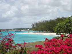
A tradition has recently developed for tourists in Oistins to join in with locals at the Friday night (and slightly quieter Saturday night) Fish Fry and "lime" (social gathering) which sees many stalls selling fried fish meals and local craft, all to the accompaniment of loud music, while older inhabitants practice more traditional 'old time' dancing. The area is fairly close to many of the south coast hotels in Barbados and has several very attractive beaches, for example Miami Beach
Miami Beach, Barbados
Miami Beach, Barbados, near the town of Oistins, is a popular sandy beach in Barbados. It is located on the south coast of the island, with usually calm waters and brilliant sunset views. On its north side is Enterprise Beach, a much more sheltered bay popular with families. Miami Beach is popular...
.
Many like the beaches in Oistins because they are on the flight path of many jets landing at the Grantley Adams International Airport
Grantley Adams International Airport
Grantley Adams International Airport , is found in Seawell, Christ Church on the island of Barbados. The former name of the airport was Seawell Airport before being dedicated in honour of the first Premier of Barbados, Sir Grantley Herbert Adams in 1976. The airport's timezone is GMT –4, and is...
. Sun bathers and those in the water can watch as every plane to Barbados swoops down from the sky on its final approach to a landing at the airport some 1-2 kilometres to the north and east. Some try to pass their time on the beach by guessing what will be the next airline approaching, before the plane's markings are visible once the aircraft passes directly overhead.
External links
- Oistins in line for facelift: March 7th, 2006 - Barbados Nation News