
Oio Region
Encyclopedia
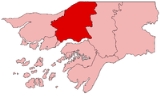
Oio is a region in Guinea-Bissau
. Its capital is Farim
. Other major cities and towns include Nhacra
, Mansoa
, Bissorã
and Cumeré
. The region borders Senegal
to the north, the Guinea-Bissau regions of Bafatá
, Bissau and Biombo
to the east, the Rio Geba/Guinea-Bissau region of Quinara
to the south and the Guinea-Bissau region of Cacheu
to the west.
The Rio de Canjambari
flows through the north of the region.
One of the highest place in Oio is Tambandinto with an elevation of 70 m.
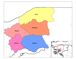 Oio is divided into five sectors:
Guinea-Bissau
The Republic of Guinea-Bissau is a country in West Africa. It is bordered by Senegal to the north, and Guinea to the south and east, with the Atlantic Ocean to its west....
. Its capital is Farim
Farim
Farim is a town of northern Guinea-Bissau. It sits on the north bank of the Farim/Cacheu River, about 135 miles up the river from Cacheu. Population 6,405 .-History:...
. Other major cities and towns include Nhacra
Nhacra
Nhacra is a town in the Oio Region of Guinea-Bissau....
, Mansoa
Mansôa
Mansôa is a town located in the Oio Region of Guinea-Bissau. Population 7,376 .-References:...
, Bissorã
Bissorã
Bissorã is a town located in the Oio Region of Guinea-Bissau.Population 11,964 .-History:After the abrupt independence from Portugal in 1974 due to the Lisbon's Carnation Revolution, many of the Guinean black soldiers that served in the Portuguese Army and who had fought against the independence...
and Cumeré
Cumeré
Cumeré is a town in the Oio Region of Guinea-Bissau....
. The region borders Senegal
Senegal
Senegal , officially the Republic of Senegal , is a country in western Africa. It owes its name to the Sénégal River that borders it to the east and north...
to the north, the Guinea-Bissau regions of Bafatá
Bafatá Region
Bafatá is a region in north-central Guinea-Bissau, with a population of 225.516 . Its capital is Bafatá.Bafatá is divided into 6 sectors:*Bafatá*Bambadinca*Contuboel*Galomaro*Gamamundo*XitoleSee also:*Regions of Guinea-Bissau...
, Bissau and Biombo
Biombo Region
Biombo is a region in western Guinea-Bissau, with an area of 840 km2. Its capital is Quinhámel. Its population in 2004 was 63,835, compared with 60,400 at the 1991 Census. The region is Governed by Mr...
to the east, the Rio Geba/Guinea-Bissau region of Quinara
Quinara Region
Quinara is a region in central Guinea-Bissau. Its capital is Buba.Quinara is divided into 4 sectors:*Buba*Empada*Fulacunda*TiteSee also:*Regions of Guinea-Bissau*Sectors of Guinea-Bissau...
to the south and the Guinea-Bissau region of Cacheu
Cacheu Region
Cacheu is a region in western Guinea-Bissau, on the border with Senegal. It has an area of 5,175 km2 and a population estimated in 2004 at 164,676. Its capital is Cacheu.Cacheu is divided into 6 administrative sectors:*Bigene*Bula*Cacheu*Caió...
to the west.
The Rio de Canjambari
Rio de Canjambari
The Rio de Canjambari is a river which flows through the Oio Region of Guinea-Bissau....
flows through the north of the region.
One of the highest place in Oio is Tambandinto with an elevation of 70 m.
- BissorãBissorãBissorã is a town located in the Oio Region of Guinea-Bissau.Population 11,964 .-History:After the abrupt independence from Portugal in 1974 due to the Lisbon's Carnation Revolution, many of the Guinean black soldiers that served in the Portuguese Army and who had fought against the independence...
- FarimFarimFarim is a town of northern Guinea-Bissau. It sits on the north bank of the Farim/Cacheu River, about 135 miles up the river from Cacheu. Population 6,405 .-History:...
- MansabaMansabaMansaba is a Sector in the Oio Region of Guinea-Bissau....
- MansoaMansôaMansôa is a town located in the Oio Region of Guinea-Bissau. Population 7,376 .-References:...
- NhacraNhacraNhacra is a town in the Oio Region of Guinea-Bissau....
A-B
| Elevation | Altitude |
|---|---|
| Alabato Alabato Alabato is a village in the Oio Region of northern Guinea-Bissau. It is located east of Cufeu.-External links:*... (12.4891667°N 15.3555556°W) |
18 m |
| Amina Dala | 40 m |
| Badancar Badancar Badancar is a village in the Oio Region of northern Guinea-Bissau. It is located to the south of Dungal, Guinea-Bissau.-External links:*... |
|
| Bafata | 45 m (150 ft) |
| Bafatandim (12.3811111°N 15.3488889°W | 1.8 m |
| Bagadage | 47 m |
| Baite | 31 m |
| Bambaia Bambaia, Oio Bambaia is a village in the Oio Region of northern Guinea-Bissau. It is located west of Casa Nova and northeast of Mansaba.-External links:*... |
13 m |
| Bananto | 47 m |
| Bancolene | 57 m |
| Bantasso | 34 m |
| Baradoulo | 1 m |
| Biambe | 50 m |
| Bija | 4 m |
| Bijine | 58 m |
| Binar | 48 m |
| Binar | 39 m |
| Binibaque (12.0511111°N 15.4013889°W) | 101 m |
| Binta (12.4202778°N 15.3180556°W) | 1 m |
| Bissorã | 7 m |
| Bissorã (12.2230556°N 15.4475°W) | 39 m |
| Bissum | 44 m |
| Blafechuro | 29 m |
| Blassar | 10 m |
| Bolumbati | 13 m |
| Braia | 8 m |
| Bricama | |
| Brufa | 11 m |
| Buara | 34 m |
| Buborim | 1 m |
| Bucancadi | 48 m |
| Budo | 9 m |
| Buduco | 24 m |
| Bupe | 49 m |
| Burume | 24 m |
C-D
| Elevation | Altitude |
|---|---|
| Ca Cumba | 44 m |
| Ca Mamadu (12.0513889°N 15.0741667°W | 1 m |
| Ca Quebo | 48 m |
| Ca Sanima | 41 m |
| Cai | 25 m |
| Cama | 45 m |
| Camalem | 14 m |
| Cambajo | 55 m |
| Cancunco | 38 m |
| Canfanda | 7 m |
| Canico | 19 m |
| Canico (12.4555556°N 15.2716667°W) | 33 m |
| Canico Tumana | 14 m |
| Canjaja Mandinga | 6 m |
| Canjambari | 15 m |
| Canjambari Morocunda (12.48555556°N 15.0108333°W) | 40 m |
| Canjambari Morocunda | 40 m |
| Canjanco (12.5086111°N 15.1633333°W) | 2 m |
| Cansambo | 11 |
| Cansenha | 10 m |
| Cansonoco Fula | 16 m |
| Cantaco (long: 12.3677778°N 15.3497222°W) | 5 m |
| Capol | 46 m |
| Casa Nova | |
| Cate | 29 m |
| Caurba (long: 12.4452778°N 15.3175°W), | 2 m |
| Caurdim | 1 m |
| Chale | 42 m |
| Changalana | 7 m |
| Changue | 34 m |
| Changue Bedeta | 7 m |
| Chile | 35 m |
| Chombe (long: 12.2038889°N 15.6736111°W) | 1 m |
| Chompundo (long: 12.2322222°N 15.6575°W) | 44 m |
| Chumbune | 56 m |
| Coduco | 20 m |
| Coli Sare | 53 m |
| Colimansacunda | 50 m |
| Concolim | 36 m |
| Confandinto | 36 m |
| Contuba | 41 m |
| Contubo | |
| Cossiba | 16 m |
| Cossicunto | 28 m |
| Crescimo | 31 m |
| Cubane | 53 m |
| Cuboi | 1 m |
| Cuboi (12.1516667°N 15.4433333°W) | 8 m |
| Cubonge | 38 m |
| Cucuto | 75 m |
| Cudana | 54 m |
| Cufar | 9 m |
| Cufeu Cufeu Cufeu is a village in the Oio Region of northern Guinea-Bissau. It is located west of Alabato.-External links:*... (12.4947222°N 15.3841667°W) |
51 m |
| Cumbija 12 m | |
| Cumbule | 27 m |
| Cumeré | |
| Dambera | 8 m |
| Dame | 47 m |
| Dana (12.0583333°N 15.3627778°W) | 8 m |
| Dando Dando Dando as a surname can refer to the following people:*Carolyn Dando, New Zealand actress and soprano*Evan Dando, American musician and member of the band The Lemonheads*Jill Dando, British television personality who was murdered in 1999... |
14 m |
| Dara | 52 m |
| Demba So | 51 m |
| Dinul | 48 m |
| Dungal Dungal -People:* Saint Dungal* Dungal of Bobbio* Indrechtach mac Dungalaig* Dúngal Eilni mac Scandail* Dúngal mac Amalgado* Dúngal mac Cellaig* Dúngal mac Selbaig or Dungal of Dalriada-Places:*Dungal, Guinea-Bissau, near Badancar... |
56 m |
| Dutato | 48 m |
| Dutato | 51 m |
E-F
| Elevation | Altitude |
|---|---|
| Embande | 49 m |
| Embunhe (12.1591667°N 15.4197222°W) | 42 m |
| Empanquinhame | 23 m |
| Fabur | 16 m |
| Faca FACA FACA may be:* Federal Advisory Committee Act, a United States statute* Federation of Anglican Churches in the Americas* Military of the Central African Republic, les Forces armées centrafricaines* Fiji Cycling Association... (12.4866667°N 15.4544444°W) |
10 m |
| Fagi | 50 m |
| Fajonquito | 52 m |
| Fajonquito (12.5383333°N 15.4°W) | 60 m |
| Fambanta | 58 m |
| Fanhe | 38 m |
| Farandito | 1 m |
| Farim | 2 m |
| Farinco Fula | 57 m |
| Farinco Mandinga (12.5922222°N 15.2125°W) | 22 m |
| Fatim | 48 m |
| Flanque Inture | 22 m |
| Foncho | 46 m |
| Forol (12.3761111°N 15.5091667°W) | 39 m |
G-H
| Elevation | Altitude |
|---|---|
| Ga Crico | 2 m |
| Ga Crico | 4 m |
| Ga Fara (12.1655556°N 15.2702778°W) | 10 m |
| Ga Ualia | 60 m |
| Galo Gega | 61 m |
| Gambia | 4 m |
| Ganjogude | 61 m |
| Gansambo | 11 m |
| Gebacunda | 33 m |
| Gendo (12.4030556°N 15.02°W) | 52 m |
| Genico | 6 m |
| Grancuta | 16 m |
| Guidaje | 55 m |
| Gulcunhe (12.2458333°N 15.4336111°W) | 54 m |
| Gussara | 22 |
I-J
| Elevation | Altitude |
|---|---|
| Iangana | 46 m |
| Iara 12.358°N 15.515°W | 5 m |
| Iarom | 59 m |
| Iarom | 9 m |
| Imboe | 36 m |
| Impasse (12.0591667°N 15.4961111°W) | 30 m |
| Ionfarim | 37 m |
| Iongoto (12.3072222°N 15.5019444°W) | 52 m |
| Irabato | 4 m |
| Iracunda | 22 m |
| Iusse | 54 m |
| Jabel Jabel Jabel is a municipality in the Mecklenburgische Seenplatte district, in Mecklenburg-Vorpommern, Germany.... |
51 m |
| Jabico (12.5794444°N 15.2708333°W) | 25 m |
| Jagali | 47 m |
| Jagali Balanta | 8 m |
| Jimba | 31 m |
| Jugudul | 31 m |
| Jugudul Com | 39 m (131 ft) |
| Jumbembem |
L-M
| Elevation | Altitude |
|---|---|
| Lamoi | 47 m |
| Late (12.0769444°N 15.4472222°W) | 34 m |
| Lendend | 21 m |
| Leto (12.3777778°N 15.3958333°W) | 2 m |
| Libari (12.2652778°N 15.5588889°W) | 40 m |
| Locher | 35 m |
| Lubacunda | 4 m |
| Madane | 15 m |
| Madina | 28 m |
| Madina (12.505°N 15.98°W) | 56 m |
| Madina Madinga | 50 m |
| Madina Mandinga | 37 m |
| Malafo | 22 m |
| Malafo (12.1744444°N 15.3813889°W) | 24 m |
| Malibolom | 39 m |
| Mambonco (12.2469444°N 15.2011111°W) | 54 m |
| Manaca Manaca Manaca is a rechargeable contactless smart card used in Nagoya, Japan and the surrounding area since February 11, 2011. It replaced the existing Tranpass magnetic fare card system, both in scope and function.-Introduction:... |
59 m |
| Mandingara (12.1708333°N 15.1936111°W) | 5 m |
| Manecunda | 1 m |
| Manga (12.0677778°N 15.5619444°W) | 35 m |
| Manhau | 55 m |
| Maninha (12.4475°N 15.0863889°W) | 48 m |
| Mansaba Mansaba Mansaba is a Sector in the Oio Region of Guinea-Bissau.... |
15 m |
| Mansabadim (12.2116667°N 15.3847222°W) | 53 m |
| Mansacunsa | 24 m |
| Mansalia (12.4569444°N 15.4297222°W) | 3 m |
| Mansasunto | 41 m |
| Mansoa Mansôa Mansôa is a town located in the Oio Region of Guinea-Bissau. Population 7,376 .-References:... |
3 m |
| Mansode | 28 m |
| Mansomine (12.3988889°N 15.1475°W) | 55 m |
| Mantefa | 47 m |
| Mantida (12.3033333°N 15.0677778°W) | 54 m |
| Maque | 46 m |
| Maquezinho (12.3086111°N 15.363889°W) | 19 m |
| Marecunda | 8 m |
| Matar Matar Matar may refer to:* Matar, another name for the star Eta Pegasi* USS Matar, Crater-class cargo ship commissioned by the U.S. Navy for service in World War II-People:* Agapius II Matar Patriarch of the Melkite Greek Catholic Church from 1796 to 1812... (12.3455556°N 15.5088889°W) |
42, |
| Mato Vaz | 17 m |
| Mindodo | 20 m |
| Missira | 9 m |
| Missira | 31 m |
| Mone Moné Ramona DeSouza, more popularly known as Moné, is an American music recording artist and songwriter. She scored three hits on the US Billboard Hot Dance Music/Club Play chart: "We Can Make It" , "Movin'" and "Partay Feeling"... |
29 m |
| Mores (12.2447222°N 15.2755556°W) | 55 m |
N-O
| Elevation | Coordinates | Altitude |
|---|---|---|
| Nafula | 58 m | |
| Naga de Baixo | (12.2341667°N 15.6994444°W) | |
| Nagate | 2 m | |
| Nhae | 43 m | |
| Nhae | 21 m | |
| Nhamate | 9 m | |
| Nhambura | 35 | |
| Nhane | 35 m | |
| Nhanfa | 53 | |
| Nhenque | 9 m | |
| Nhenque | 11 m | |
| Nhime | 15 m | |
| Nimane | 5 m | |
| Norobanta Fula | 6 m | |
| Norobanta Mandinga | 44 m | |
| Olom | 15 m | |
| Olossato | 12°19′11"N 15°19′43"W | 4 m |
P-Q
| Elevation | Coordinates | Altitude |
|---|---|---|
| Pache | 39 m | |
| Passe | 12.234444°N 15.5786111°W | 52 m |
| Passe | 45 m | |
| Ponta Sinoi | 31 m | |
| Quenhequenheto | 12°9′5"N 15°13′00"W | 4 m |
R-S
| Elevation | Coordinates | Altitude |
|---|---|---|
| Rossum Rossum -People:*Allen Rossum , an American football cornerback and return specialist*Emmy Rossum , an American actress and singer-songwriter*Kristin Rossum , murderer who poisoned her husband-Places:... |
20 m | |
| Saba | 53 m | |
| Sadejar de Binar | 12.135°N 15.6025°W | 29 m |
| Saliquinhe | 1 m | |
| Saliquinhedim | 12.4527778°N 15.22°W | 12 m |
| Sama | 12.64°N 15.1269444°W | 53 m |
| Samandim | 12 m | |
| Samandim | 12.64°N 15.1269444°W | 56 m |
| Samoje | 46 m | |
| Sancalanco | 12.5266667°N 15.1988889°W | 17 m |
| Sano | 45 m | |
| Sansabato | 12.265°N 15.3475°W | 58 m |
| Sansancutoto | 33 m | |
| Sansanto | 12.1144444°N 15.2827778°W | 22 m |
| Santambato | 12.2244444°N 15.2430556°W | 54 m |
| Santancoto | 12.4175°N 15.4177778°W | 33 m |
| Santanto | 12.3166667°N 15.2686111°W | 9 |
| Sara | 52 m | |
| Sare Bori | 24 m | |
| Sare Coli Cebo | 66 m | |
| Sare Demba | 23 m | |
| Sare Demba Embalo | 50 m | |
| Sare Demba Taquel | 12.6658333°N 15.0175°W | 48 m |
| Sare Ioba | 10 m | |
| Sare Jobo | 12.2861111°N 15.1591667°W | 21 M |
| Sare Lamine | 40 m | |
| Sare Leao | 12.6061111°N 15.0916667°W | 46 m |
| Sare Mancama | 32 m | |
| Sare Mancama | 12.6069444°N 15.1033333°W | 12 m |
| Sare Pate | 57 m | |
| Sare Quecuta | 12.6030556°N 15.0522222°W | 5 m |
| Sare Samba Fil | 12.6344444°N 15.0302778°W | 14 m |
| Sare Samba Iafa | 6 m | |
| Sare Samba Seidi | 16 m | |
| Sare Tenem | 17 m | |
| Sarube | 12.2833333°N 15.519444°W | 13 m |
| Selim | 34 m | |
| Simbor | 43 m | |
| Sincha Madina | 30 m | |
| Sincha Meta | 45 m | |
| Singa | 12.0938889°N 15.1955556°W | 36 m |
| Sinre | 24 m | |
| Sobea | 24 m | |
| Sogume | 12.0383333°N 15.3541667°W | 22 m |
| Solinto | 41 m | |
| Solinto Mandinga | 31 m | |
| Sorimone | 12.2408333°N 15.4897222°W | 36 m |
| Suarecunda | 38 m |
T-U
| Elevation | Coordinates | Altitude |
|---|---|---|
| Tabandinto | 36 m | |
| Talico | 12.4608333°N 15.4622222°W | 17 m |
| Tama | 17 m | |
| Tambandinto | 12.5108333°N 15.077778°W | 70 m |
| Tambato | 47 m | |
| Tambato | 12.4285°N 15.278333°W | 3 m |
| Tambato Mandinga | 29 m | |
| Tambico | 12.4363889°N 15.0522222°W | 22 M |
| Tancroal | 31 m | |
| Tebede | 12.2169444°N 15.6713889°W | 13 m |
| Tehe | 12.2211111°N 15.5025°W | 46 m |
| Temanto | 49 m | |
| Tento | 56 m | |
| Tungina | 1 m | |
| Ualia | 14 m | |
| Uanquelim | 12.1363889°N 15.4136111°W | 39 m |
| Uapete | 38 m | |
| Uaque | 11 m | |
| Uassando | 12.225°N 15.1277778°W | 43 m |
| Uassadu | 51 m | |
| Uatine | 12.2063889°N 15.4483333°W | 10 m |
| Udasse | 9 m | |
| Uenquem | 27 m | |
| Uensaco | 12.6316667°N 15.2788889°W | 27 m |
| Ufude | 43 m | |
| Ujeque | 18 m | |
| Ululo | 54 m | |
| Umpaba | 48 m | |
| Unche | 12.0241667°N 15.6239556°W | 40 m |
| Unfarim | 50 m | |
| Ungro | 12.0405556°N 15.4855556°W | 33 m |
External links
See also:- Regions of Guinea-BissauRegions of Guinea-Bissau||Guinea-Bissau is divided into 8 regions and 1 autonomous sector . The regions are listed below :*Bafatá Region *Biombo Region...
- Sectors of Guinea-BissauSectors of Guinea-Bissau||There are 37 sectors of Guinea-Bissau which subdivide the regions. The sectors are listed below, by region:-Bafata Region:*Bafata*Bambadinca*Contuboel*Galomaro*Gamamundo*Xitole-Biombo Region:*Prabis*Quinhamel*Safim...