

Oakland Hills, Oakland, California
Encyclopedia
Oakland, California
Oakland is a major West Coast port city on San Francisco Bay in the U.S. state of California. It is the eighth-largest city in the state with a 2010 population of 390,724...
, California
California
California is a state located on the West Coast of the United States. It is by far the most populous U.S. state, and the third-largest by land area...
.
The geologic feature
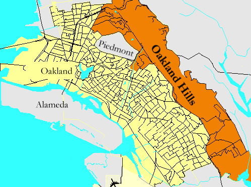
"Oakland Hills" is most commonly an informal name for that section of the Berkeley HillsBerkeley Hills
The Berkeley Hills are a range of the Pacific Coast Ranges that overlook the northeast side of the valley that surrounds San Francisco Bay. They were previously called the "Contra Costa Range/Hills" , but with the establishment of Berkeley and the University of California, the current usage was...
range which extends along the eastern side of Oakland, California
Oakland, California
Oakland is a major West Coast port city on San Francisco Bay in the U.S. state of California. It is the eighth-largest city in the state with a 2010 population of 390,724...
. In recent decades, it has become the more common popular term although it remains "officially" incorrect among geographers and gazetteers. Before the establishment of the University of California
University of California
The University of California is a public university system in the U.S. state of California. Under the California Master Plan for Higher Education, the University of California is a part of the state's three-tier public higher education system, which also includes the California State University...
in Berkeley, the range was called the Contra Costa Hills.
To add confusion, the common usage often also includes another officially unnamed ridge which runs in front (west) of the Berkeley/"Oakland" Hills, as well as the linear valley enclosed between the two ridges in the Montclair District
Montclair, Oakland, California
Montclair is a neighborhood of Oakland, California. Montclair is located in the hills east of Piedmont in a valley formed by the Hayward Fault...
along State Route 13. This other ridge, a shutter ridge
Shutter ridge
A shutter ridge is a ridge which has moved along a fault line, blocking or diverting drainage. Typically, a shutter ridge creates a valley corresponding to the alignment of the fault that produces it. Shutter ridges occur exclusively at strike-slip faults...
created by the Hayward Fault, lends its informal name, "Rockridge
Rockridge, Oakland, California
Rockridge is a residential neighborhood and commercial district in Oakland, California. Rockridge is generally defined as the area east of Telegraph Avenue, south of the Berkeley city limits, west of the Oakland hills and north of the intersection of Pleasant Valley Avenue/51st Street and...
", only to the district of Oakland at its northwest end, although it extends southeast to the junction of Highway 13 and I-580
Interstate 580 (California)
Interstate 580 is an 80-mile east–west Interstate Highway in Northern California. The heavily traveled spur route of Interstate 80 runs from San Rafael in the San Francisco Bay Area to Interstate 5 near Tracy in the Central Valley...
in East Oakland and includes most of the small residential community of Piedmont, California
Piedmont, California
Piedmont is a small, affluent city in Alameda County, California, United States. It is surrounded by the city of Oakland. The population was 10,667 at the 2010 census. Piedmont was incorporated in 1907 and was developed significantly in the 1920s and 1930s...
.
Oakland Hills Neighborhoods
The Oakland Hills neighborhoods comprise the highest elevations within the city's land area, following the alignment of the hills and the central section of the Hayward Fault ZoneHayward Fault Zone
The Hayward Fault Zone is a geologic fault zone capable of generating significantly destructive earthquakes. This strike-slip fault is about long, situated mainly along the western base of the hills on the east side of San Francisco Bay...
. The area includes all of Oakland lying east of State Route 13 and east of I-580
Interstate 580 (California)
Interstate 580 is an 80-mile east–west Interstate Highway in Northern California. The heavily traveled spur route of Interstate 80 runs from San Rafael in the San Francisco Bay Area to Interstate 5 near Tracy in the Central Valley...
south of its junction with Route 13. The area includes Upper Rockridge, Oakmore, Montclair and Mountain View Cemetery. The Oakland Hills area touches the eastern border of Piedmont, California
Piedmont, California
Piedmont is a small, affluent city in Alameda County, California, United States. It is surrounded by the city of Oakland. The population was 10,667 at the 2010 census. Piedmont was incorporated in 1907 and was developed significantly in the 1920s and 1930s...
and includes a section of Claremont
Claremont, Oakland/Berkeley, California
The Claremont district is a neighborhood straddling the city limits of Oakland and Berkeley in the East Bay section of the San Francisco Bay Area in California, United States. It lies at an elevation of 266 feet . The main thoroughfares are Claremont and Ashby Avenues.The name was given in the...
; the northern part of Claremont lies within the city of Berkeley
Berkeley, California
Berkeley is a city on the east shore of the San Francisco Bay in Northern California, United States. Its neighbors to the south are the cities of Oakland and Emeryville. To the north is the city of Albany and the unincorporated community of Kensington...
. The Oakland Hills neighborhood area includes the northern section of Lake Chabot Regional Park
Lake Chabot Regional Park
Lake Chabot Regional Park is a regional park located in Alameda County, CA that is part of the East Bay Regional Parks system. The northern part of the lake and park lie within the boundary of the city of Oakland, CA, while the southern part lies in an unicoproarted area of Alameda County adjacent...
and borders Robert Sibley Volcanic Regional Preserve
Robert Sibley Volcanic Regional Preserve
Robert Sibley Volcanic Regional Preserve is located in the Berkeley Hills just east of Oakland, California, USA. Though it can only be entered via Oakland, it actually lies almost entirely within Contra Costa County....
, Huckleberry Botanic Regional Preserve
Huckleberry Botanic Regional Preserve
Huckleberry Botanic Regional Preserve is a regional park and nature reserve in the eastern San Francisco Bay Area, in Alameda and Contra Costa Counties, Northern California. It is a park within the East Bay Regional Parks District system...
, Redwood Regional Park
Redwood Regional Park
Redwood Regional Park is a park of the East Bay Regional Parks District in the San Francisco Bay Area. It is located in the hills east of Oakland. The park contains the largest remaining natural stand of coast redwood found in the East Bay. Redwood forests are more commonly found closer to the...
and Anthony Chabot Regional Park
Anthony Chabot Regional Park
Anthony Chabot Regional Park is a regional park on in the San Leandro Hills adjacent to Oakland, San Leandro and Castro Valley.The park is adjacent to Lake Chabot Regional Park and also to EBMUD's Upper San Leandro Reservoir. It houses a golfing club and a marksmanship club...
; all part of the East Bay Regional Park District
East Bay Regional Park District
The East Bay Regional Park District is a special district operating in Alameda County and Contra Costa County, California, within the East Bay area of the San Francisco Bay Area...
.
Neighborhoods
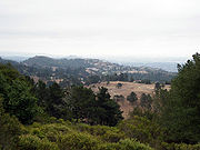
Northeast Hills
- ClaremontClaremont, Oakland/Berkeley, CaliforniaThe Claremont district is a neighborhood straddling the city limits of Oakland and Berkeley in the East Bay section of the San Francisco Bay Area in California, United States. It lies at an elevation of 266 feet . The main thoroughfares are Claremont and Ashby Avenues.The name was given in the...
(southern portion) - Forestland
- Glen Highlands
- Hiller Highlands
- Joaquin Miller ParkJoaquin Miller ParkJoaquin Miller Park is a large open space park in the Oakland Hills owned and operated by the city of Oakland, California. It was named after early California writer and poet Joaquin Miller, who lived here in his house "The Hights", now preserved as the Joaquin Miller House.-Park:The park's are...
- Lake TemescalLake TemescalLake Temescal is a small lake in the northeastern hills section of Oakland, California. It is the centerpiece of Temescal Regional Park...
- Merriwood
- MontclairMontclair, Oakland, CaliforniaMontclair is a neighborhood of Oakland, California. Montclair is located in the hills east of Piedmont in a valley formed by the Hayward Fault...
- Montclair Business District
- Mountain View Cemetery
- OakmoreOakmore, Oakland, CaliforniaOakmore is a neighborhood in Oakland, California that is off Leimert Street and above Dimond Park. This neighborhood was built in the 1920s and 1930s for people who worked in San Francisco and took the Key Route to work. The Key System was a primary user of the Leimert Bridge, which connects...
- Panoramic HillPanoramic Hill, Oakland/Berkeley, CaliforniaPanoramic Hill is a residential neighborhood of the cities of Berkeley and Oakland, California defined by the homes along and within the access corridor defined by Panoramic Way.-Geography:...
- Piedmont PinesPiedmont Pines, Oakland, CaliforniaPiedmont Pines is a residential district in Oakland, California. It is generally bounded by Highway 13 to the west, Shepherd Canyon Rd. to the north, Skyline Dr. to the east, and Joaquin Miller Park to the south. Two Oakland public schools are included in the area, Montera Middle School and...
- Shepherd Canyon
- Upper Rockridge
Southeast Hills
- Chabot ParkChabot ParkChabot Park is a middle-class, majority African-American neighborhood in Oakland, California located in the Southeastern section of the Oakland Hills. The neighborhood is adjacent to Knowland State Park and the Oakland Zoo....
- Crestmont
- Sequoyah HeightsSequoyah Heights, Oakland, CaliforniaSequoyah Heights is a smaller part of the Oak Knoll neighborhood that runs alongside the southeastern part of the Oakland hills. The neighborhood borders San Leandro....
- Sheffield
- Skyline-Hillcrest Estates
- Caballo Hills
- Leona Heights
- Chabot Park
- Woodminster
Sociological composition
The Oakland Hills have historically less violent crime, higher household incomes, lower unemployment rates, higher home values, older population and fewer Black and Hispanic residents than the flatlands of Oakland.Culture
- Chabot Space and Science CenterChabot Space and Science CenterChabot Space and Science Center, located in Oakland, California, is a hands-on center featuring interactive exhibits, a digital planetarium, a large screen theater, hands-on activities and three powerful telescopes....
- Woodminster Summer Musicals
- Montclair Jazz & Wine Festival
- Joseph Knowland State Arboretum and ParkJoseph Knowland State Arboretum and ParkJoseph Knowland State Arboretum and Park is a park located in the Grass Valley neighborhood of Oakland, California, formerly a state park, now property of the City of Oakland and the location of the Oakland Zoo.-Park creation:...
- Oakland ZooOakland ZooOakland Zoo, in the past known as the Knowland Zoo, is a zoo located in southeastern Oakland, California, United States. Oakland Zoo is relatively small for a city of its size, but it contains modern exhibits. Most of its animals are kept in relatively "natural" habitats, and expanded natural...