
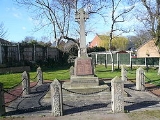
North Wingfield
Encyclopedia
North Wingfield is a large village in the English
county of Derbyshire
, located approximately 4½ miles south-east of Chesterfield
, and 1 mile north-east of Clay Cross
. It is in the North East Derbyshire
district. The A6175 road from the M1 motorway
to the A61 road
runs through the village.
The village contains the former hamlets of Hepthorne Lane, Hillyfields, Highfields and Church Hill. The Hepthorne Lane area is still called by its name by local residents, as, occasionally, is the Highfields area. The River Rother
flows through the village at the bottom of Hepthorne Lane, next to the Midland Main Line
.
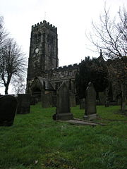 During the Domesday Book
survey in 1086, the manor of North Wingfield was known as Winnefelt. It was noted that there was a church and a priest. Parts of the current church, dedicated to St. Lawrence, date from the Norman era, with some features being Saxon
in origin.
The manor of North Wingfield during the Domesday surveys was in the possession of Walter De Ayncourt
. The name eventually became shortened to Deincourt, which is now used by the village's secondary school
, Deincourt Community School.
By the 1660s George Sitwell
built his own furnace at Foxbrooke near Renishaw
. However the novelty was the East Midlands' first rolling and slitting mill near Renishaw some years later.
, a junior school
and Deincourt Community School.
Located in the former coalfield
s, the village was served by several collieries for most of its recent history. Now, partly due to its location near to the M1 motorway
and its three schools, the village has experienced an influx of residents in recent years, with many housing developments having taken place.
placed Deincourt Community School under 'special measures', due to inspectors' concerns about falling standards at the school. In 2008 the school was earmarked for closure with the 473 students at the school possibly being transferred to the newly-built Tibshelf
Community School. Should these plans go ahead, the site could be partly used to construct a new £6.5m building for a new, combined primary school in the village.
Derbyshire County Council plans to close Deincourt Community School as part of its Building Schools for the Future
scheme; it is proposed that the catchment areas of Tupton Hall School
and Tibshelf Community School will be extended.
North Wingfield Primary School was founded in Victorian times; it was formerly an infant and junior school on a split site but is now a primary school with the headteacher Mrs. Christene Leeson.Ofsted
has now placed the school under 'special measures', due to inspectors' concerns about falling standards and teaching at the school.
, Grassmoor
, Holmewood
, Pilsley , Danesmoor and Clay Cross
. North Wingfield is quite a distance away from its counterpart South Wingfield
, which is around 11 miles southwards.
England
England is a country that is part of the United Kingdom. It shares land borders with Scotland to the north and Wales to the west; the Irish Sea is to the north west, the Celtic Sea to the south west, with the North Sea to the east and the English Channel to the south separating it from continental...
county of Derbyshire
Derbyshire
Derbyshire is a county in the East Midlands of England. A substantial portion of the Peak District National Park lies within Derbyshire. The northern part of Derbyshire overlaps with the Pennines, a famous chain of hills and mountains. The county contains within its boundary of approx...
, located approximately 4½ miles south-east of Chesterfield
Chesterfield
Chesterfield is a market town and a borough of Derbyshire, England. It lies north of Derby, on a confluence of the rivers Rother and Hipper. Its population is 70,260 , making it Derbyshire's largest town...
, and 1 mile north-east of Clay Cross
Clay Cross
Clay Cross is a former mining town and civil parish in the North East Derbyshire district of Derbyshire, England, about six miles south of Chesterfield. It is directly on the A61, the former Roman road Ryknield Street...
. It is in the North East Derbyshire
North East Derbyshire
North East Derbyshire is a local government district in Derbyshire, England. It borders the districts of Chesterfield, Bolsover, Amber Valley and Derbyshire Dales in Derbyshire, and Sheffield and Rotherham in South Yorkshire....
district. The A6175 road from the M1 motorway
M1 motorway
The M1 is a north–south motorway in England primarily connecting London to Leeds, where it joins the A1 near Aberford. While the M1 is considered to be the first inter-urban motorway to be completed in the United Kingdom, the first road to be built to motorway standard in the country was the...
to the A61 road
A61 road
The A61 is a major trunk road in England. It runs from Derby to Thirsk in North Yorkshire. From Derby, it heads north via Alfreton, Clay Cross, Chesterfield, Sheffield, Barnsley, Wakefield, Leeds, Harrogate and Ripon...
runs through the village.
The village contains the former hamlets of Hepthorne Lane, Hillyfields, Highfields and Church Hill. The Hepthorne Lane area is still called by its name by local residents, as, occasionally, is the Highfields area. The River Rother
River Rother, South Yorkshire
The River Rother is a river in the northern midlands of England, after which the town of Rotherham and the Rother Valley parliamentary constituency are named. It rises near Clay Cross in Derbyshire, and flows through the centre of Chesterfield, where it feeds the Chesterfield Canal...
flows through the village at the bottom of Hepthorne Lane, next to the Midland Main Line
Midland Main Line
The Midland Main Line is a major railway route in the United Kingdom, part of the British railway system.The present-day line links London St...
.
Brief history
Domesday Book
Domesday Book , now held at The National Archives, Kew, Richmond upon Thames in South West London, is the record of the great survey of much of England and parts of Wales completed in 1086...
survey in 1086, the manor of North Wingfield was known as Winnefelt. It was noted that there was a church and a priest. Parts of the current church, dedicated to St. Lawrence, date from the Norman era, with some features being Saxon
Anglo-Saxon architecture
Anglo-Saxon architecture was a period in the history of architecture in England, and parts of Wales, from the mid-5th century until the Norman Conquest of 1066. Anglo-Saxon secular buildings in Britain were generally simple, constructed mainly using timber with thatch for roofing...
in origin.
The manor of North Wingfield during the Domesday surveys was in the possession of Walter De Ayncourt
Walter D'Aincourt
Walter D'Aincourt accompanied William the Conqueror to England in 1066 and was rewarded with a large number of manors in a number of counties but particularly Nottinghamshire after the Norman conquest.-Biography:...
. The name eventually became shortened to Deincourt, which is now used by the village's secondary school
Secondary school
Secondary school is a term used to describe an educational institution where the final stage of schooling, known as secondary education and usually compulsory up to a specified age, takes place...
, Deincourt Community School.
By the 1660s George Sitwell
George Sitwell (Sheriff)
George Sitwell was the leading ironmaster in North Derbyshire and North Nottinghamshire in the seventeenth century.. He built Renishaw Hall in Derbyshire in 1626. He mined, forged, and rolled iron for use in Britain and overseas...
built his own furnace at Foxbrooke near Renishaw
Renishaw, Derbyshire
Renishaw is a village in the district of North East Derbyshire in England.Renishaw lies on the A6135 between the villages of Eckington and Barlborough. To the west of the village is a section of the Trans Pennine Trail long distance footpath which runs along a former railway line. Adjacent to this...
. However the novelty was the East Midlands' first rolling and slitting mill near Renishaw some years later.
The Village
The village has an infantInfant school
An Infant school is a term used primarily in the United Kingdom for school for children between the ages of four and seven years. It is usually a small school serving a particular locality....
, a junior school
Junior school
A junior school is a type of school which caters for children, often between the ages of 7 and 11.-Australia:In Australia, a junior school is usually a part of a private school that educates children between the ages of 5 and 12....
and Deincourt Community School.
Located in the former coalfield
Coalfield
A coalfield is an area of certain uniform characteristics where coal is mined. The criteria for determining the approximate boundary of a coalfield are geographical and cultural, in addition to geological...
s, the village was served by several collieries for most of its recent history. Now, partly due to its location near to the M1 motorway
M1 motorway
The M1 is a north–south motorway in England primarily connecting London to Leeds, where it joins the A1 near Aberford. While the M1 is considered to be the first inter-urban motorway to be completed in the United Kingdom, the first road to be built to motorway standard in the country was the...
and its three schools, the village has experienced an influx of residents in recent years, with many housing developments having taken place.
Tibshelf Community School
In November 2007, OfstedOfsted
The Office for Standards in Education, Children's Services and Skills is the non-ministerial government department of Her Majesty's Chief Inspector of Schools In England ....
placed Deincourt Community School under 'special measures', due to inspectors' concerns about falling standards at the school. In 2008 the school was earmarked for closure with the 473 students at the school possibly being transferred to the newly-built Tibshelf
Tibshelf
Tibshelf is a village and civil parish in Derbyshire, England. It is in the Bolsover district of the county. Its population at the 2001 UK census was 3,548....
Community School. Should these plans go ahead, the site could be partly used to construct a new £6.5m building for a new, combined primary school in the village.
Derbyshire County Council plans to close Deincourt Community School as part of its Building Schools for the Future
Building Schools for the Future
Building Schools for the Future is the name of the previous UK Government's investment programme in secondary school buildings in England. The program is very ambitious in its costs, timescales and objectives, with politicians from all English political parties supportive of the principle but...
scheme; it is proposed that the catchment areas of Tupton Hall School
Tupton Hall School
Tupton Hall School is one of the largest secondary schools in the North East Derbyshire district with a large body of students and one of the largest sixth forms in the county.-Grammar School:...
and Tibshelf Community School will be extended.
North Wingfield Primary School was founded in Victorian times; it was formerly an infant and junior school on a split site but is now a primary school with the headteacher Mrs. Christene Leeson.Ofsted
Ofsted
The Office for Standards in Education, Children's Services and Skills is the non-ministerial government department of Her Majesty's Chief Inspector of Schools In England ....
has now placed the school under 'special measures', due to inspectors' concerns about falling standards and teaching at the school.
Neighbouring settlements
Neighbouring settlements are TuptonTupton
Tupton is a village in North East Derbyshire, Derbyshire, England, south of Chesterfield. It lies just north of Clay Cross on the A61 which runs from Chesterfield to Alfreton. It comprises the areas of Old Tupton and New Tupton. However, it is generally referred to as Tupton...
, Grassmoor
Grassmoor
Grassmoor is a village in Derbyshire, England, approximately three miles to the south of Chesterfield. Its original name, according to 16th-century parish records, was Gresmore. Grassmoor formally housed many miners, however all of the local mines in the area have been closed since the...
, Holmewood
Holmewood
Holmewood is a village in the North East Derbyshire district of Derbyshire, being a former coal mining village with close links to the villages of Heath, North Wingfield and Temple Normanton....
, Pilsley , Danesmoor and Clay Cross
Clay Cross
Clay Cross is a former mining town and civil parish in the North East Derbyshire district of Derbyshire, England, about six miles south of Chesterfield. It is directly on the A61, the former Roman road Ryknield Street...
. North Wingfield is quite a distance away from its counterpart South Wingfield
South Wingfield
South Wingfield is a village in the Scarsdale Hundred of Derbyshire, England, and is now part of the district council area of Amber Valley.An ex-mining village, it has a mixed community. Its most famous landmark is Wingfield Manor, a ruined manor house built around 1450. It is situated about from...
, which is around 11 miles southwards.
Facilities
- PharmacyPharmacyPharmacy is the health profession that links the health sciences with the chemical sciences and it is charged with ensuring the safe and effective use of pharmaceutical drugs...
- Two GPGeneral practitionerA general practitioner is a medical practitioner who treats acute and chronic illnesses and provides preventive care and health education for all ages and both sexes. They have particular skills in treating people with multiple health issues and comorbidities...
surgeriesSurgerySurgery is an ancient medical specialty that uses operative manual and instrumental techniques on a patient to investigate and/or treat a pathological condition such as disease or injury, or to help improve bodily function or appearance.An act of performing surgery may be called a surgical... - Newsagents
- Post OfficePost officeA post office is a facility forming part of a postal system for the posting, receipt, sorting, handling, transmission or delivery of mail.Post offices offer mail-related services such as post office boxes, postage and packaging supplies...
- Co-Op UKCo-op UKThe United Kingdom is home to a widespread and diverse co-operative movement, with over 3 million individual members. Modern co-operation started with the Rochdale Pioneers' shop in the northern English town of Rochdale in 1844....
Superstore - Sure StartSure StartSure Start is a UK Government initiative applying in England, originating with HM Treasury, with the aim of "giving children the best possible start in life" through improvement of childcare, early education, health and family support, with an emphasis on outreach and community development...
centre (information) - Community Resource Centre (information)
- Various locally-run shops.
- Recycling facilities