
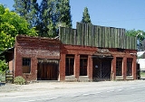
North San Juan, California
Encyclopedia
North San Juan is a census-designated place
in Nevada County
, California
, United States
, along State Route 49
on the San Juan Ridge
in Gold Country
. The zip code is 95960. The population was 269 at the 2010 census.
and it prospered during the era of hydraulic mining
at nearby Malakoff Diggins State Historic Park
from 1850-1884. Beginning in 1867, it was included on the route for the first long-distance telephone line
, a historical landmark, between French Corral and French Lake
.
In 1880, the population was 675.
The original name San Juan was bestowed by a veteran of the Mexican-American War who settled there in 1853 because he thought the site looked like San Juan de Ulúa
near Veracruz
. When the post office opened in 1857 "North" was added to distinguish it from San Juan in San Benito County
.
, the CDP covers an area of 2.4 square miles (6.3 km²), all of it land.
was 111.1 people per square mile (42.9/km²). The racial makeup of North San Juan was 224 (83.3%) White, 1 (0.4%) African American, 12 (4.5%) Native American, 11 (4.1%) Asian, 0 (0.0%) Pacific Islander, 0 (0.0%) from other races
, and 21 (7.8%) from two or more races. Hispanic or Latino of any race were 9 persons (3.3%).
The Census reported that 269 people (100% of the population) lived in households, 0 (0%) lived in non-institutionalized group quarters, and 0 (0%) were institutionalized.
There were 130 households, out of which 25 (19.2%) had children under the age of 18 living in them, 38 (29.2%) were opposite-sex married couples
living together, 17 (13.1%) had a female householder with no husband present, 7 (5.4%) had a male householder with no wife present. There were 13 (10.0%) unmarried opposite-sex partnerships
, and 0 (0%) same-sex married couples or partnerships. 51 households (39.2%) were made up of individuals and 13 (10.0%) had someone living alone who was 65 years of age or older. The average household size was 2.07. There were 62 families
(47.7% of all households); the average family size was 2.71.
The population was spread out with 43 people (16.0%) under the age of 18, 10 people (3.7%) aged 18 to 24, 67 people (24.9%) aged 25 to 44, 111 people (41.3%) aged 45 to 64, and 38 people (14.1%) who were 65 years of age or older. The median age was 49.8 years. For every 100 females there were 124.2 males. For every 100 females age 18 and over, there were 115.2 males.
There were 146 housing units at an average density of 60.3 per square mile (23.3/km²), of which 62 (47.7%) were owner-occupied, and 68 (52.3%) were occupied by renters. The homeowner vacancy rate was 1.6%; the rental vacancy rate was 0%. 137 people (50.9% of the population) lived in owner-occupied housing units and 132 people (49.1%) lived in rental housing units.
Census-designated place
A census-designated place is a concentration of population identified by the United States Census Bureau for statistical purposes. CDPs are delineated for each decennial census as the statistical counterparts of incorporated places such as cities, towns and villages...
in Nevada County
Nevada County, California
Nevada County is a county located in the Sierra Nevada of California, in the Mother Lode country. As of 2010 its population was 98,764. The county seat is Nevada City.-History:Nevada County was created in 1851 from parts of Yuba County....
, California
California
California is a state located on the West Coast of the United States. It is by far the most populous U.S. state, and the third-largest by land area...
, United States
United States
The United States of America is a federal constitutional republic comprising fifty states and a federal district...
, along State Route 49
California State Route 49
State Route 49 is a north–south state highway in the U.S. state of California that passes through many historic mining communities of the 1849 California gold rush. Highway 49 is numbered after the "49ers", the waves of immigrants who swept into the area looking for gold, and a portion of it...
on the San Juan Ridge
San Juan Ridge
The San Juan Ridge is a geographic featureextending approximately east-northeast between the South and Middle Yuba Rivers in the foothills of the northern Sierra Nevada Mountains...
in Gold Country
Gold Country
Gold Country is a region in the central and northeastern part of California, United States. It is famed for the mineral deposits and gold mines that attracted waves of immigrants, known as the 49ers, during the 1849 California Gold Rush.-Geography:State Route 49 was built through the Gold Country,...
. The zip code is 95960. The population was 269 at the 2010 census.
History
The community's beginnings date back to the California Gold RushCalifornia Gold Rush
The California Gold Rush began on January 24, 1848, when gold was found by James W. Marshall at Sutter's Mill in Coloma, California. The first to hear confirmed information of the gold rush were the people in Oregon, the Sandwich Islands , and Latin America, who were the first to start flocking to...
and it prospered during the era of hydraulic mining
Hydraulic mining
Hydraulic mining, or hydraulicking, is a form of mining that uses high-pressure jets of water to dislodge rock material or move sediment. In the placer mining of gold or tin, the resulting water-sediment slurry is directed through sluice boxes to remove the gold.-Precursor - ground...
at nearby Malakoff Diggins State Historic Park
Malakoff Diggins State Historic Park
Malakoff Diggins State Historic Park belongs to the California State Historic Park system, a part of the California Department of Parks and Recreation. Malakoff Diggins is the site of California's largest hydraulic mines...
from 1850-1884. Beginning in 1867, it was included on the route for the first long-distance telephone line
First long-distance telephone line
The world's first long-distance telephone line, established in 1877, connected French Corral with Bowman Lake at the headwaters of the Yuba River...
, a historical landmark, between French Corral and French Lake
French Lake, California
French Lake, California , located in Nevada County, was a California Gold Rush community, now uninhabited. It was located by a lake of the same name....
.
In 1880, the population was 675.
The original name San Juan was bestowed by a veteran of the Mexican-American War who settled there in 1853 because he thought the site looked like San Juan de Ulúa
San Juan de Ulúa
San Juan de Ulúa, also known as Castle of San Juan de Ulúa is a large complex of fortresses, prisons and one former palace on an island overlooking the seaport of Veracruz, Mexico.-History:...
near Veracruz
Veracruz
Veracruz, formally Veracruz de Ignacio de la Llave officially Estado Libre y Soberano de Veracruz de Ignacio de la Llave , is one of the 31 states that, along with the Federal District, comprise the 32 federative entities of Mexico. It is divided in 212 municipalities and its capital city is...
. When the post office opened in 1857 "North" was added to distinguish it from San Juan in San Benito County
San Benito County, California
San Benito County is a county located in the Coast Range Mountains of the U.S. state of California, south of San Jose. As of 2010 the population was 55,269. The county seat is Hollister, which includes nearly two-thirds of the county's population. El Camino Real passes through the county and...
.
Geography
According to the United States Census BureauUnited States Census Bureau
The United States Census Bureau is the government agency that is responsible for the United States Census. It also gathers other national demographic and economic data...
, the CDP covers an area of 2.4 square miles (6.3 km²), all of it land.
Demographics
The 2010 United States Census reported that North San Juan had a population of 269. The population densityPopulation density
Population density is a measurement of population per unit area or unit volume. It is frequently applied to living organisms, and particularly to humans...
was 111.1 people per square mile (42.9/km²). The racial makeup of North San Juan was 224 (83.3%) White, 1 (0.4%) African American, 12 (4.5%) Native American, 11 (4.1%) Asian, 0 (0.0%) Pacific Islander, 0 (0.0%) from other races
Race (United States Census)
Race and ethnicity in the United States Census, as defined by the Federal Office of Management and Budget and the United States Census Bureau, are self-identification data items in which residents choose the race or races with which they most closely identify, and indicate whether or not they are...
, and 21 (7.8%) from two or more races. Hispanic or Latino of any race were 9 persons (3.3%).
The Census reported that 269 people (100% of the population) lived in households, 0 (0%) lived in non-institutionalized group quarters, and 0 (0%) were institutionalized.
There were 130 households, out of which 25 (19.2%) had children under the age of 18 living in them, 38 (29.2%) were opposite-sex married couples
Marriage
Marriage is a social union or legal contract between people that creates kinship. It is an institution in which interpersonal relationships, usually intimate and sexual, are acknowledged in a variety of ways, depending on the culture or subculture in which it is found...
living together, 17 (13.1%) had a female householder with no husband present, 7 (5.4%) had a male householder with no wife present. There were 13 (10.0%) unmarried opposite-sex partnerships
POSSLQ
POSSLQ is an abbreviation for "Persons of Opposite Sex Sharing Living Quarters," a term coined in the late 1970s by the United States Census Bureau as part of an effort to more accurately gauge the prevalence of cohabitation in American households....
, and 0 (0%) same-sex married couples or partnerships. 51 households (39.2%) were made up of individuals and 13 (10.0%) had someone living alone who was 65 years of age or older. The average household size was 2.07. There were 62 families
Family (U.S. Census)
A family or family household is defined by the United States Census Bureau for statistical purposes as "a householder and one or more other people related to the householder by birth, marriage, or adoption. They do not include same-sex married couples even if the marriage was performed in a state...
(47.7% of all households); the average family size was 2.71.
The population was spread out with 43 people (16.0%) under the age of 18, 10 people (3.7%) aged 18 to 24, 67 people (24.9%) aged 25 to 44, 111 people (41.3%) aged 45 to 64, and 38 people (14.1%) who were 65 years of age or older. The median age was 49.8 years. For every 100 females there were 124.2 males. For every 100 females age 18 and over, there were 115.2 males.
There were 146 housing units at an average density of 60.3 per square mile (23.3/km²), of which 62 (47.7%) were owner-occupied, and 68 (52.3%) were occupied by renters. The homeowner vacancy rate was 1.6%; the rental vacancy rate was 0%. 137 people (50.9% of the population) lived in owner-occupied housing units and 132 people (49.1%) lived in rental housing units.