

North Qu'Appelle No. 187, Saskatchewan
Encyclopedia
Rural municipality
A rural municipality, often abbreviated RM, is a form of municipality in the Canadian provinces of Manitoba and Saskatchewan, perhaps best comparable to counties or townships in the western United States...
in south eastern Saskatchewan
Saskatchewan
Saskatchewan is a prairie province in Canada, which has an area of . Saskatchewan is bordered on the west by Alberta, on the north by the Northwest Territories, on the east by Manitoba, and on the south by the U.S. states of Montana and North Dakota....
. North Qu'Appelle No. 187 RM was formed December 12, 1910
Communities
The following communities are located in this municipality. The towns and villages are not technically considered to be part of the rural municipality, but the hamlets are. Also not considered to be part of the R.M. are several First NationsFirst Nations
First Nations is a term that collectively refers to various Aboriginal peoples in Canada who are neither Inuit nor Métis. There are currently over 630 recognised First Nations governments or bands spread across Canada, roughly half of which are in the provinces of Ontario and British Columbia. The...
Indian reserve
Indian reserve
In Canada, an Indian reserve is specified by the Indian Act as a "tract of land, the legal title to which is vested in Her Majesty, that has been set apart by Her Majesty for the use and benefit of a band." The Act also specifies that land reserved for the use and benefit of a band which is not...
s that lie within the territory of North Qu'Appelle No 187.
Towns
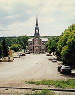
- Fort Qu'AppelleFort Qu'Appelle, SaskatchewanThese figures do not include the substantial population living along the shores of the Fishing Lakes.-Origins:The current site is the third Fort Qu'Appelle. The first was a North West Company trading post , also in the valley but near what is now the Saskatchewan-Manitoba border...
Villages
Resort Villages
- B-Say-Tah
- Fort SanFort San, SaskatchewanFort San is a former sanatorium, now a resort village, surrounded by the rural municipality of North Qu'Appelle No. 187, Saskatchewan, Canada. The village is located approximately 77 km northeast of Regina and 3 km west of Fort Qu'Appelle...
Organized Hamlets
- Pasqua LakePasqua Lake, SaskatchewanPasqua Lake is a hamlet in the Canadian province of Saskatchewan. Listed as a designated place by Statistics Canada, the hamlet had a population of 224 in the Canada 2006 Census....
- Taylor BeachTaylor Beach, SaskatchewanTaylor Beach is a hamlet in the Canadian province of Saskatchewan. Listed as a designated place by Statistics Canada, the hamlet had a population of 39 in the Canada 2006 Census....
Hamlets
- Katepwa South
- Lakeview Beach
Rm Profile
According to the Canada 2001 CensusCanada 2001 Census
The Canada 2001 Census was a detailed enumeration of the Canadian population. Census day was May 15, 2001. On that day, Statistics Canada attempted to count every person in Canada. The total population count of Canada was 30,007,094. This was a 4% increase over 1996 Census of 28,846,761. In...
:
- Population: 838
- % Change (1996–2001): 1.2
- Dwellings: 724
- Area (km²): 496.14
- Density (persons per km²): 1.7
Saskatchewan Railways and Railway Stations
(historic or current)- Swan River - Preeceville - Melville - Regina Branch C.N.RCanadian National RailwayThe Canadian National Railway Company is a Canadian Class I railway headquartered in Montreal, Quebec. CN's slogan is "North America's Railroad"....
-- serves Melville, Colmer, Duff, Finnie, Lorlie, Gillespie, Balcarres, Hugonard, Lebret, Fort Qu'Appelle, Muscow, Edgeley, Avonhurst, Edewold, Frankslake, Zehner, Victoria Plains, Regina.
Saskatchewan Highways and Roads
- For more information see also List of Saskatchewan provincial highways
- For more information see also List of Saskatchewan provincial roads
- Highway 56Saskatchewan Highway 56Highway 56 is a highway in the Canadian province of Saskatchewan. It runs from Highway 1 near Indian Head to Highway 210 within the Echo Valley Provincial Park. Highway 56 is about 57 km long....
-- serves Lebret - Highway 10Saskatchewan Highway 10Highway 10 is a provincial paved undivided highway in the Canadian province of Saskatchewan. It runs from Highway 1 near Balgonie until it transitions into PTH 5 at the Manitoba border. Highway 10 is about 228 km long....
-- serves Fort Qu'AppelleFort Qu'Appelle, SaskatchewanThese figures do not include the substantial population living along the shores of the Fishing Lakes.-Origins:The current site is the third Fort Qu'Appelle. The first was a North West Company trading post , also in the valley but near what is now the Saskatchewan-Manitoba border... - Highway 20Saskatchewan Highway 20Highway 20 is a major road intended for travel by the public between Highway 11 Lumsden to Highway 3 at Birch Hills. Saskatchewan's main roadways are located in the central/southern geographical land area of rolling prairie and grass land in a western Canadian prairie province. This highway is one...
- Highway 35Saskatchewan Highway 35Highway 35 is a paved undivided provincial highway in the Canadian province of Saskatchewan. It runs from the US Border near Port of Oungre to a dead end near the north shore of Tobin Lake. Saskatchewan Highway 35 SK Hwy 35) is about long. The CanAm Highway comprises Saskatchewan Highways 35,...
-- serves Fort Qu'AppelleFort Qu'Appelle, SaskatchewanThese figures do not include the substantial population living along the shores of the Fishing Lakes.-Origins:The current site is the third Fort Qu'Appelle. The first was a North West Company trading post , also in the valley but near what is now the Saskatchewan-Manitoba border... - Highway 22Saskatchewan Highway 22Highway 22 is a highway in the Canadian province of Saskatchewan connecting Highway 20 near Earl Grey to Provincial Road 478 Manitoba border near Esterhazy.-Communities along the route:*Bulyea*Earl Grey*Southey*Markinch*Cupar*Lipton*Fort San...
-- intersects with Saskatchewan Highway 35Saskatchewan Highway 35Highway 35 is a paved undivided provincial highway in the Canadian province of Saskatchewan. It runs from the US Border near Port of Oungre to a dead end near the north shore of Tobin Lake. Saskatchewan Highway 35 SK Hwy 35) is about long. The CanAm Highway comprises Saskatchewan Highways 35,...
External links
- 2001 Census - Statistics Canada's page on the 2001 Census.
- Map of North Qu'Appelle No. 187 at Statcan