

North Ko'olaupoko, Hawai'i
Encyclopedia
North Koolaupoko is a census-designated place
(CDP) in the City & County of Honolulu
, Hawaii
, United States
, on the island of Oahu
. The population was 726 at the 2000 census. In Hawaiian
, koolau poko means "short windward", referring to the fact that this is the shorter of the two windward districts on the island (Koolauloa or "long windward" is the other). Koolaupoko extends from Makapuu Point on the southeast to Kaōio Point on the north. Included within the district are the largest windward towns of Kāneohe, Kailua, and Waimānalo—places discussed in separate articles.
 North Koolaupoko lies mostly along the coastline of Kāneohe Bay and consists of several lush valleys that extend inland to the steep face of the Koolau pali (cliff). The first valley north of Kahaluu is Waiāhole. Next is Waikāne, then Hakipuu, and northernmost is Kualoa
. This area differs from the towns, valleys, and ahupuaa of the southern part of Koolaupoko in that it is mostly undeveloped, decidedly rural in character, with many small farms.
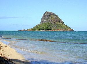
Despite the long shoreline, public access to Kāneohe Bay is somewhat limited by private holdings. A small community park at Waiāhole is being enlarged and improved (2003). A larger City & County park at Kualoa provides camping and picnic areas, a long narrow beach, and views of Mokolii Islet (Chinaman's hat). The south side of Kualoa Beach Park faces onto Kāneohe Bay and the east shore is a fringing reef off the Pacific Ocean coast of northeast Oahu.
The U.S. postal code
for all of North Koolaupoko is 96744 (the same as Kāneohe).
Although data are collected under the United States Census Bureau
tract called "Waikane", the tract encompasses much more than the place known as Waikāne, which is but one of several valleys comprising the north end of the Koolaupoko District. The census tract has a total area of 7.2 square miles (18.6 km²), of which, 6.8 square miles (17.7 km²) of it is land and 0.3 square miles (0.9 km²) of it is water. The total area is 4.88% water.
was 106.4 people per square mile (41.1/km²). There were 198 housing units at an average density of 29.0 per square mile (11.2/km²). The racial makeup of the tract was 16.94% White, 0.14% Black or African American, 0.28% Native American, 19.15% Asian, 22.45% Pacific Islander, 1.79% from other races, and 39.26% from two or more races. 5.10% of the population were Hispanic or Latino of any race.
There were 188 households out of which 32.4% had children under the age of 18 living with them, 59.0% were married couples
living together, 14.4% had a female householder with no husband present, and 16.5% were non-families. 11.2% of all households were made up of individuals and 4.3% had someone living alone who was 65 years of age or older. The average household size was 3.86 and the average family size was 4.09.
In the CDP the population was spread out with 28.1% under the age of 18, 8.1% from 18 to 24, 26.9% from 25 to 44, 27.4% from 45 to 64, and 9.5% who were 65 years of age or older. The median age was 34 years. For every 100 females there were 96.2 males. For every 100 females age 18 and over, there were 94.8 males.
The median income for a household in the CDP was $55,179, and the median income for a family was $53,625. Males had a median income of $31,786 versus $25,313 for females. The per capita income
for the tract was $15,592. 11.6% of the population and 4.3% of families were below the poverty line. Out of the total population, 16.1% of those under the age of 18 and 2.0% of those 65 and older were living below the poverty line.
Census-designated place
A census-designated place is a concentration of population identified by the United States Census Bureau for statistical purposes. CDPs are delineated for each decennial census as the statistical counterparts of incorporated places such as cities, towns and villages...
(CDP) in the City & County of Honolulu
Honolulu County, Hawaii
The City and County of Honolulu is a consolidated city–county located in the U.S. state of Hawaii. The municipality and county includes both the urban district of Honolulu and the rest of the island of Oahu, as well as several minor outlying islands, including all of the Northwestern Hawaiian...
, Hawaii
Hawaii
Hawaii is the newest of the 50 U.S. states , and is the only U.S. state made up entirely of islands. It is the northernmost island group in Polynesia, occupying most of an archipelago in the central Pacific Ocean, southwest of the continental United States, southeast of Japan, and northeast of...
, United States
United States
The United States of America is a federal constitutional republic comprising fifty states and a federal district...
, on the island of Oahu
Oahu
Oahu or Oahu , known as "The Gathering Place", is the third largest of the Hawaiian Islands and most populous of the islands in the U.S. state of Hawaii. The state capital Honolulu is located on the southeast coast...
. The population was 726 at the 2000 census. In Hawaiian
Hawaiian language
The Hawaiian language is a Polynesian language that takes its name from Hawaii, the largest island in the tropical North Pacific archipelago where it developed. Hawaiian, along with English, is an official language of the state of Hawaii...
, koolau poko means "short windward", referring to the fact that this is the shorter of the two windward districts on the island (Koolauloa or "long windward" is the other). Koolaupoko extends from Makapuu Point on the southeast to Kaōio Point on the north. Included within the district are the largest windward towns of Kāneohe, Kailua, and Waimānalo—places discussed in separate articles.
Kualoa Ranch
Kualoa Ranch is the landowner of Kaaawa Valley, also commonly known as Kualoa Valley, on the windward coast of the island of Oahu in Hawaii. This place was sacred to ancient Oahuans from the 13th to the 18th century, as it was where Laa-mai-kahiki settled after visiting Kauai and before returning...
. This area differs from the towns, valleys, and ahupuaa of the southern part of Koolaupoko in that it is mostly undeveloped, decidedly rural in character, with many small farms.
Despite the long shoreline, public access to Kāneohe Bay is somewhat limited by private holdings. A small community park at Waiāhole is being enlarged and improved (2003). A larger City & County park at Kualoa provides camping and picnic areas, a long narrow beach, and views of Mokolii Islet (Chinaman's hat). The south side of Kualoa Beach Park faces onto Kāneohe Bay and the east shore is a fringing reef off the Pacific Ocean coast of northeast Oahu.
The U.S. postal code
Postal code
A postal code is a series of letters and/or digits appended to a postal address for the purpose of sorting mail. Once postal codes were introduced, other applications became possible.In February 2005, 117 of the 190 member countries of the Universal Postal Union had postal code systems...
for all of North Koolaupoko is 96744 (the same as Kāneohe).
Geography
Waikāne is located at 21°29'47" North, 157°51'34" West (21.496355, -157.859321). Southward along the shore of Kāneohe Bay via Kamehameha Highway (State Rte. 83) are (from Waikāne): Waiāhole and Kahaluu. Northwest up the coast beyond Kualoa and Kaōio Point is the town of Kaaawa.Although data are collected under the United States Census Bureau
United States Census Bureau
The United States Census Bureau is the government agency that is responsible for the United States Census. It also gathers other national demographic and economic data...
tract called "Waikane", the tract encompasses much more than the place known as Waikāne, which is but one of several valleys comprising the north end of the Koolaupoko District. The census tract has a total area of 7.2 square miles (18.6 km²), of which, 6.8 square miles (17.7 km²) of it is land and 0.3 square miles (0.9 km²) of it is water. The total area is 4.88% water.
Demographics
As of the 2000 census, there were 726 people in the northern part of the Koolaupoko District, with 188 households and 156 families residing in the census tract. The population densityPopulation density
Population density is a measurement of population per unit area or unit volume. It is frequently applied to living organisms, and particularly to humans...
was 106.4 people per square mile (41.1/km²). There were 198 housing units at an average density of 29.0 per square mile (11.2/km²). The racial makeup of the tract was 16.94% White, 0.14% Black or African American, 0.28% Native American, 19.15% Asian, 22.45% Pacific Islander, 1.79% from other races, and 39.26% from two or more races. 5.10% of the population were Hispanic or Latino of any race.
There were 188 households out of which 32.4% had children under the age of 18 living with them, 59.0% were married couples
Marriage
Marriage is a social union or legal contract between people that creates kinship. It is an institution in which interpersonal relationships, usually intimate and sexual, are acknowledged in a variety of ways, depending on the culture or subculture in which it is found...
living together, 14.4% had a female householder with no husband present, and 16.5% were non-families. 11.2% of all households were made up of individuals and 4.3% had someone living alone who was 65 years of age or older. The average household size was 3.86 and the average family size was 4.09.
In the CDP the population was spread out with 28.1% under the age of 18, 8.1% from 18 to 24, 26.9% from 25 to 44, 27.4% from 45 to 64, and 9.5% who were 65 years of age or older. The median age was 34 years. For every 100 females there were 96.2 males. For every 100 females age 18 and over, there were 94.8 males.
The median income for a household in the CDP was $55,179, and the median income for a family was $53,625. Males had a median income of $31,786 versus $25,313 for females. The per capita income
Per capita income
Per capita income or income per person is a measure of mean income within an economic aggregate, such as a country or city. It is calculated by taking a measure of all sources of income in the aggregate and dividing it by the total population...
for the tract was $15,592. 11.6% of the population and 4.3% of families were below the poverty line. Out of the total population, 16.1% of those under the age of 18 and 2.0% of those 65 and older were living below the poverty line.